It would be impossible to understand the United States without knowing a bit about the differences between northeastern states like Massachusetts and southeastern states like Mississippi. To an even greater extent, a similar thing can be said of China. There are many things that make northeastern and southeastern China very different from one another. Now that China has become the second largest economy in the world, it is probably important that we learn some basic facts about these differences.
Let’s start with the geographic differences first, before moving on to economics and politics:
Topography
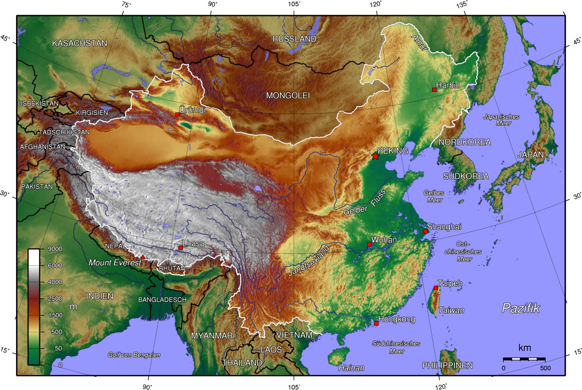
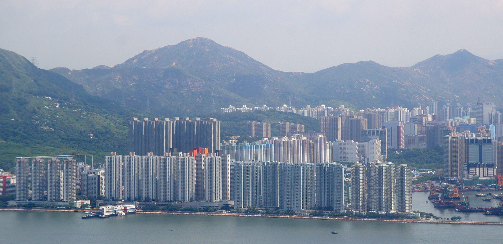
As you can see from the map above, northeastern China contains two large plains, one located immediately to the west of the Pacific Ocean and one immediately north of the Pacific Ocean. In contrast, southern China is comprised almost entirely of hills and mountains, which in most places extend as close as 1-50 km to the Pacific. This picture below of the southeastern city of Hong Kong, for instance, shows that much of its population lives in high-rise apartments that are sandwiched between mountains and the sea.
Rainfall

Southeastern China receives roughly three times as much rainfall as the coastal areas of northeastern China, and between three and twenty times as much rainfall as areas within a few hundred km inland of the coast of northeastern China.
Forests

Southeastern China is covered in many places by forests, whereas northeastern China, with the exception of the areas near the border with North Korea and Russia (which are home to only around 15 million people), is not.
Agriculture

In spite of China’s rapid industrialization, the country still relies on agriculture for around 10% of its economic output and 37% of its employment. As you can see from the map above, southeastern China primarily produces rice and tea, while northeastern China produces wheat, corn, millet, sorghum, cotton, and soybeans.
Pollution


Northeastern China, in part because it is where most of the country’s coal is produced, is generally much more polluted than southeastern China.
Language
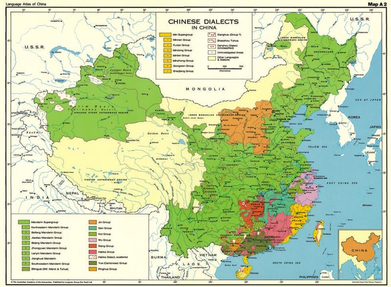
Languages and dialects are always complicated to pin down, making graphs that depict them over-simplistic in most cases. That being said, it is probably not a stretch to say that China’s regional linguistic divisions are in many cases quite substantial. Speakers of a southern Chinese dialect would not necessarily be able to converse with speakers of a northern one, for example. The map above shows that southeastern China has much more linguistic diversity than northeastern China, and less of a linguistic connection with China as a whole. The map also shows that the southeastern province of Fujian shares a linguistic connection with neighbouring Taiwan.
Ethnic Minorities

(Note: just because a place is coloured in on this map, does not mean that it is majority non-Chinese, but only that it is home to a relatively large concentration of non-Chinese. In fact, as of 2000, only the far western provinces of Xinjiang and Tibet were thought to be majority non-Chinese).
The map above does not show this, but the ethnic minorities in southeastern China have a combined population that is approximately four times larger than those of northeastern China. There is also much more ethnic diversity in southeastern China, as the map does show.
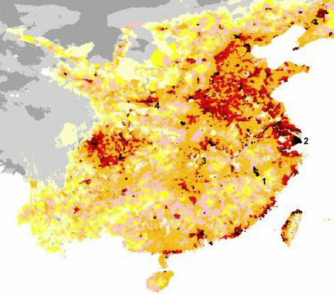
Population Density
(Keep in mind that this is China: even the orange areas of this map have population densities greater than that of the United States).
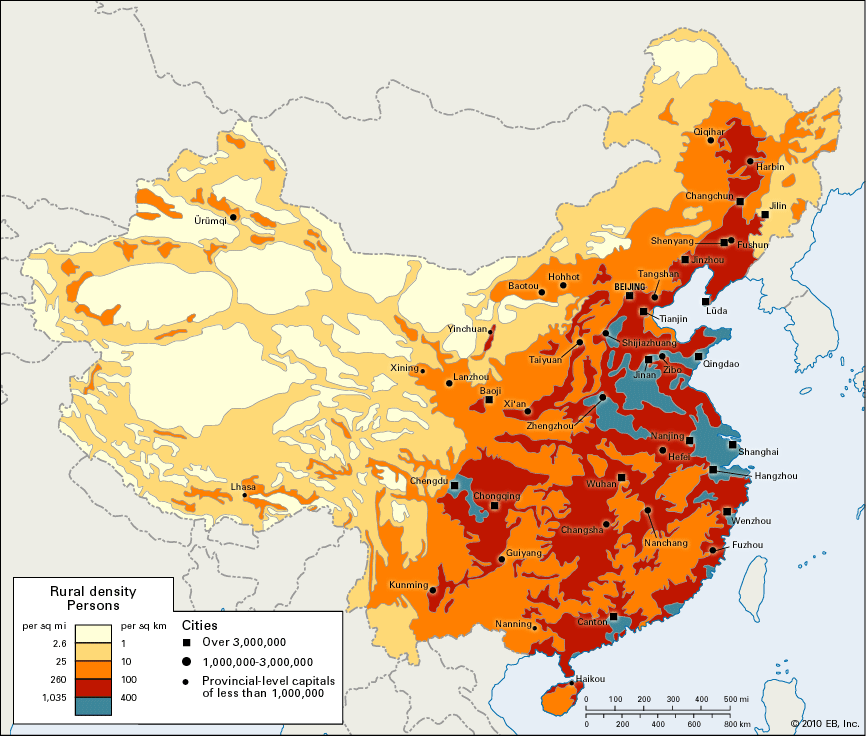
This map reveals several differences between northeastern and southeastern China. First, it shows that northeastern China’s population density is generally much higher than southeastern China’s. Second, it shows that northeastern China’s population is clustered together, whereas southeastern China’s is spread out relatively thinly in enclaves along its Pacific coast. Third, it shows that northeastern China’s highest density areas are located a few hundred km inland, while southeastern China’s high density areas are beside the sea.
Here’s a slightly more detailed map of China’s population density, which really shows this northeast-southeast difference:
Politics
Hong Kong, one of the largest cities in southern China and one of China’s two major financial centres, was a British territory until the late 1990’s. Taiwan, an island 180 km off the coast of southeastern China, has effectively been independent since the mid-twentieth century.
Today, of the 43 members of the three leading political offices in China (the Politburo of the Communist Party of China, the Secretariat of the Communist Party, and the Central Military Commission), only two were born in southern China. Of the Politburo Standing Committee (the seven-man group which is generally considered to be the top leadership of China), only one person – who is the lowest-ranked of the seven – was born in southern China. And not one person in any of those groups was born in the southern province of Guangdong, which neighbours Hong Kong and is China’s largest province both by population size and economic output. Finally, nobody born in Southeastern China or Southwestern China has ever become the ruling General Secretary of the Communist Party of China or the Premier of the People’s Republic of China.
History
This interactive map of Chinese history – http://www.timemaps.com/history/china-1500bc – describes some of the historical fault lines between northern and southern China; for example, during the 6th and 13th centuries AD and prior to the 3rd century BC.
Also not shown in this map are the different experiences northern and southern China went through when confronted with foreign powers in the 19th century. To give a simplified summary of what happened during that era, parts of southern and central China were roughly divided into Japanese, British, and French spheres of influence (with Germany, the US, and other European states also influential in certain areas), whereas northern China was by comparison left as a relatively independent state.
During the Xinhai Revolution which overthrew the last emperor of China just prior to WW1, meanwhile, it was the southern provinces where most of the earliest and most influential rebellions took place. In fact, the critical diplomatic moment of that revolution was at an international conference called the North-South Conference. Later, the Northern Expedition from 1926 – 1928 was one of the largest military campaigns in China in the first half of the twentieth century, and it reflected north-south divisions within China as well.
In the decades after that, a number of southern Chinese provinces would also play arguably the most important role in the original rising of the Communists in China against the ruling Nationalists, during the Chinese Civil War from 1927 – 1950. Finally, when the tables turned against the Nationalists in the civil war, they fled to the southeastern Chinese island of Taiwan, where they continue to govern today. Taiwan has become one of the 25 largest economies in the world, and it has particularly close commercial and social ties to mainland China’s southeastern provinces.
Economics
If you visit this interactive webpage that the Economist magazine has made – http://www.economist.com/content/chinese_equivalents – you can see a number of interesting things. First, that Hong Kong, in southeastern China, has a per capita gdp that is far higher than that of any other significant Chinese city; more than double those of Beijing or Shanghai, six times the national average, and more than 11 times that of China’s poorest province. Second, that apart from coastal areas like Guangdong, Fujian, and the city of Hong Kong, southeastern China is actually the poorest area in China, home to four of the five poorest provinces. And yet, the coastal provinces of southeastern China are for the most part just as rich as the coastal provinces of northeastern China. In fact, Taiwan, which lies off the coast of southeastern China and speaks a southeastern Chinese dialect, has a per capita income that is between 3 – 10 times greater than those of China’s provinces.
Finally, you can see that the coastal areas of southeastern and central-eastern China are much, much more dependent upon exports than other parts of China are.
Religion
Parts of Southeastern China in recent years seem to have joined Hong Kong in becoming one of the main centres of China’s potentially enormous transition toward Christianity. Today, according to the Economist, arguably more than 100 million people in China are Christian, up from perhaps as few as 15 million as recently as the 1990’s. If these numbers are accurate, then the growth of Christianity within China during the past two decades represents one of the largest religious adoptions in all of human history. Hong Kong has long had a significant Christian population, meanwhile, and remains around 10-15 percent Christian today. A number of the Hong Kong protest organizers were practicing Christians, in fact. And, notably, the Chinese government may have begun to crack down on parts of this growing Christian religion within China during the past year or so.
Energy
The vast majority of Chinese energy production is located in the north, in provinces like Shanxi and Inner Mongolia, which produce nearly all of China’s coal (and coal accounts for about 70% of Chinese energy use), and in provinces like Xinjiang and Heilongjiang, and Liaoning, which produce nearly all of China’s oil (and China is the world’s 5th largest oil producer).
Northern China also accounts for most of China’s natural gas production (7th largest in the world), natural gas imports (which come overland from Central Asia; China is the world’s 10th largest gas importer), and recoverable shale gas reserves (thought to be the world’s largest). Northern China also directly borders and has a relatively close relationship with North Korea, which has the world’s 17th highest production of coal and 2nd highest production of anthracite coal (which is the most desirable type of coal, though it only accounts for an estimated 1 percent of global coal reserves).
Southeastern and central-eastern China, in contrast, accounts for most of China’s oil imports from other countries (and China is the world’s 2nd largest oil importer), most of China’s liquified natural gas imports (5th largest in the world), most of China’s nuclear power production (5th largest in the world), most of China’s hydroelectric power (by far the largest in the world), and, in the southwestern province of Tibet, the most potential hydroelectric power in the world.
Military

According to the map above, which was made by the US Department of Defense, of the 19 major ground force units of China’s People’s Liberation Army, 6 of the 9 not to have primary missions that are defensive are the 6 that are located the furthest in southeast. 5 of the 6 that have amphibious primary missions are located in the southeast. 4 of the 5 to have mobile units are located in northern China. A 2012 Pentagon report also claims that “consistent with a near-term focus on Taiwan Strait contingencies, China bases many of its most advanced systems in the military regions opposite Taiwan”, in southeastern China.

I am going to have to look at your blog a lot more closely. I always feel that most western stuff I have read about China, its culture and its economy, does not match my experiences living there, talking to people, listening to their concerns and ideas. I have been a granny at the bottom of the tower block, along with all the other grandparents, as well as a student of the language, and a host to chinese academics visiting my home in Edinburgh, Scotland. Interested always – be back soon.