
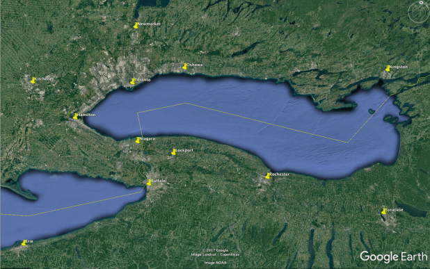
The horseshoe-shaped region that includes Toronto and Buffalo is one of North America’s most populous, with more than 10 million inhabitants.The Horseshoe’s northern half extends roughly 100 km from Oshawa in the east to Burlington in the west, and 50 km from downtown Toronto north to Newmarket. The Horseshoe’s southern half is also close to 100 km in length, from Hamilton in the west to Lockport in the east. It is 50 km from the St Catharines-Niagara area south to Buffalo.

In order for us to analyze real estate in this region, we first need to discuss three basic differences between the Horsehoe’s northern and southern halves: political, geographical, and historical differences.
Political
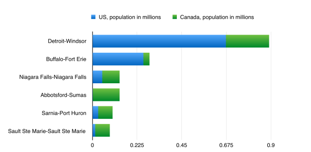
The political distinction is the most obvious of these. Whereas the northern half is entirely within Canada, the southern half is split between a Canadian side and an American side. The Canadian side of the southern half is home to roughly 1 million people, of whom 550,000 live in Hamilton. The American side is home to 1.2 million people, most of whom live in the suburbs of Buffalo. The international border runs directly through the Niagara-Buffalo urban area, making it by far the most populous urban area shared by the two countries with the exception of Detroit-Windsor:
Geographical
There is also a geographic difference between the Horseshoe’s northern and southern halves. Namely, it is that the Horseshoe’s southern cities are characterized by their relationship to water and to wind:
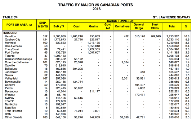
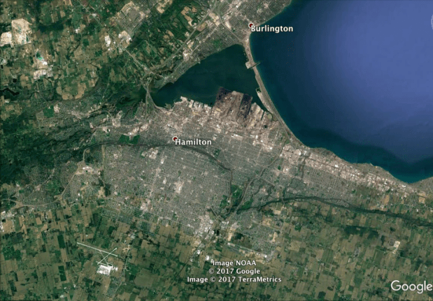
- Hamilton’s significance comes historically from the city’s harbour, which is by far the largest in the western half of Lake Ontario. The harbour facilitated shipments of bulk goods, helping Hamilton to become Canada’s Steeltown. It continues to host Canada’s largest Great Lakes port.
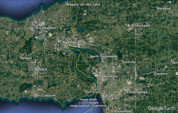
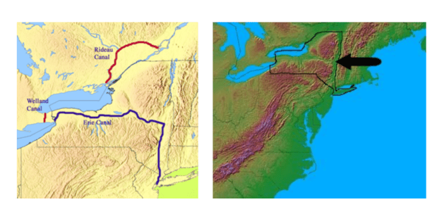
- The St Catharines-Niagara urban region, which is the 12th most populous in Canada, derives its significance from two water features. One is Niagara Falls, which draws both tourists and hydropower. The other is the Welland Canal, which connects Lake Ontario to the other Great Lakes via a series of locks, bypassing the Falls. Niagara Falls was the site of the world’s first major hydroelectric station, built in 1895. It continues to generate more power than any single dam in the United States. The Welland Canal was first built in the 1820’s, and is a key link in the St Lawrence Seaway shipping route that was opened in the mid-twentieth century.
- Upstate New York was shaped by a canal too: the Erie Canal. The canal is the main reason why Buffalo, Rochester, and Syracuse were able to grow as cities despite the heavy snowfall they receive (they are, by some estimates, the three snowiest major cities in the world, outside of cities in Quebec, Newfoundland, or Japan). In the present day the canal is used primarily (but not entirely) by pleasure-craft. However during its heydey in the nineteenth century it was one of the most economically significant waterways in North America.
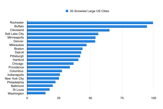
Snow in upstate New York comes mainly from winter winds blowing atop the relatively warm water of the Great Lakes. Because of these wind patterns, Buffalo actually receives twice as much snow per year on average than does Toronto. Indeed Buffalo gets more snow than any of Canada’s 18 most populous cities (a lot more snow, in most cases), with the exception of Quebec City.
Buffalo and Rochester are located in the middle of a “snowbelt”, which extends from Cleveland’s eastern suburbs all the way to the Adirondack Mountains east of Lake Ontario. The only other snowbelt cities with more than 100,000 inhabitants are Sudbury, Barrie, Syracuse, and Grand Rapids.

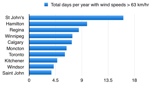
While Hamilton lies outside of any snowbelts (it gets the same amount of snow as Toronto, on average), it too is impacted by wind, being hit by among the most windstorms of any Canadian city:
Historical
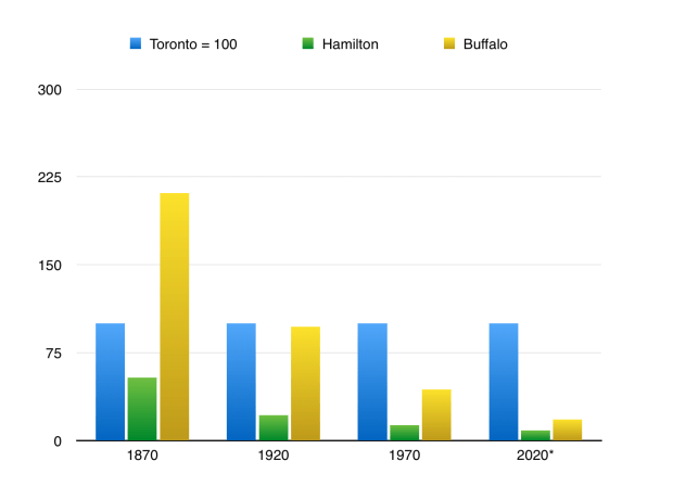
Today, the Greater Toronto Area has an estimated 6.4 million inhabitants. The southern side of the Horseshoe (Hamilton + the Niagara Region + the Greater Buffalo Area) has just half that, 3.2 million.
A little over a century ago these positions were reversed. Back in the late nineteenth century Buffalo’s population was more than twice as large as Toronto’s. In 1900 Buffalo was the eighth largest city in the US, and the fourth largest without an ocean port. Even Hamilton was not much smaller than Toronto in those days:
There are a number of reasons for this historic reversal, but they all have to do with the price of energy:
- Oil
- Automobiles
- Air Conditioning
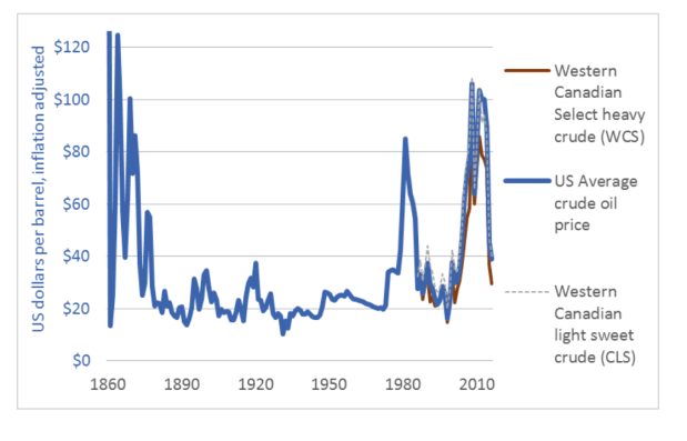
Cheap oil in the twentieth and late nineteenth centuries, and the technological advances of automobiles and air conditioning that cheap energy helped to make feasible, resulted in the decline of Buffalo and Hamilton relative to Toronto.
-Home air conditioning began to become widespread in the middle of the twentieth century. Not surprisingly, it led many Americans to move from cities like Buffalo to the Sunbelt. An estimated 28 percent of Americans lived in the Sunbelt in 1950; 40 percent did in 2000.
-For Sunbelt cities in the arid American Southwest, cheap energy was also necessary to ensure freshwater supplies, given the energy-water nexus. And for cities in the western half of the United States in general, cheap energy was needed to facilitate long-distance intercity transportation.
-Cheap oil also allowed land transportation — trains and automobiles — to supplant water transportation. Water transportation is far more energy-efficient than any other type of transportation, but it is also slow and inconvenient. With land transportation becoming dominant during the twentieth century, the importance of cities which were based around water transportation declined. Buffalo and Hamilton were two such cities.
-Buffalo and Hamilton were also not ideally suited to land transportation. For the Niagara peninsula, Lake Ontario and Lake Erie serve as transportation barriers for cars, trucks, and trains; so too does the Niagara Escarpment, which divides the peninsula (and Hamilton) into upper and lower segments. For Buffalo, lake-effect snow also frequently serves as a severe transportation barrier.
Toronto, in contrast, has been able to use automobiles and low energy prices to expand approximately 50 km deep into its GTA suburbs to the east, west, and north. Because it is a Canadian city, Toronto has also not had to worry as much about people moving south to the Sunbelt, as Buffalo has.
Speculating About The Future
Since we do not know what future energy prices will be, prudence suggests that we should prepare for the worst: high prices. Indeed, it seems far from implausible that high prices will become a reality, whether because of carbon pricing or because of a diminishing supply of “conventional” oil. Even in spite of the current shale oil boom in the US, few people have predicted a repeat of the low prices of the 1990s or the 1880-1970 era.
If energy prices do become high, the Golden Horseshoe may look more like it did in the late nineteenth century. Just like how cheap energy allowed the Greater Toronto Area to grow relative to Buffalo and Hamilton, so might expensive energy allow Buffalo and Hamilton to grow relative to the GTA. Similarly, what growth the GTA does experience in an energy-expensive world would be likelier to occur mainly within the City of Toronto, rather than in the GTA’s sprawling suburbs as has occured in recent decades.
At the same time, we can also expect technology to have an effect on the region. In the last century new technologies like automobiles and air conditioners had the largest impact. But how will today’s new technologies – digital technologies – impact the Golden Horseshoe?
One impact of digital technology is likely to be that computers and machines will allow more work to be outsourced or automated. As such, people’s leisure time will increase faster than will their disposable income. From a transportation perspective, this will probably benefit water transportation, which is the cheapest but also the slowest form of transportation. Only someone with a limited budget and a lot of free time would find travelling by water useful; especially if they are trying to avoid carbon emissions.
In particular, water-based shortcuts could become popular. It is just 47 km from St Catharines to downtown Toronto by water, but 113 km by road. Given that ferries are already more energy-efficient than automobiles or even trains on a km-by-km basis, having such a significant shortcut could be highly useful. Buffalo is in a somewhat similar position: it is 93 km from Buffalo to downtown Toronto as the crow flies, but 161 km by road.
Technology could also make intermodal transportation more convenient. For example, one lesson of the failed Toronto-Rochester ferry was the importance of the “first-mile/last-mile” challenge. Because downtown Rochester is over a dozen kilometres inland from its ferry port, and because downtown Toronto did not have good transit ties to its own ferry port in the Portlands, the ferry was not very useful. The ferry had to reserve most of its space for cars rather than for passengers, so that passengers could drive to and from its ports. The cars also accounted for most of the weight on the ferry, reducing the ferry’s energy efficiency.
With new technologies, however, such as car-sharing services or even self-driving cars, the challenge of getting to and from the ferry port could be eliminated. The ferry would no longer need to be a car-ferry.
More leisure time could also help cities like St Catharines, Welland, Niagara Falls, and Buffalo. It is difficult for cars to cross the Welland Canal because, given the large ships that use the canal on a frequent basis, the only bridges allowed over the canal are lift-bridges. Traffic backups frequently ensue when the lift-bridges are raised. This is why urban development in St Catharines, Welland, and Port Colborne has been mostly limited to only the western side of the canal.
If people have more free time, however, they may not mind waiting as long — particularly if their car is driving autonomously while they are waiting. A similar thing is true for waiting in a long line of vehicles to cross the US-Canada border.
Autonomous vehicles could be useful in other ways as well. In areas where human drivers face difficulty or delay, such robots could be highly useful. For example in upstate New York’s snowbelt, cars and trucks with high-tech safety features could be a game-changer for transportation during the winter.
So too could autonomous snowplows. Snowplow drivers are expensive to employ, given that it takes a long time to plow snow and given that they are often hired to work in the wee hours of the night. Autonomous snow cleaners could also help a lot in hard-to-reach places where snow can be very damaging: on rooftops.
Autonomous trucks could also help Buffalo and the Niagara Region by making it cheaper to cross the US-Canada border, where currently it is often expensive to pay truck drivers to wait in long, slow border lines.
Autonomous cargo ships could benefit this region too. They could allow for smaller vessels to be used on the Great Lakes at times when they would otherwise not be employed, such as at night during the winter. They could help save on labour costs for ships traversing the Welland Canal, which because of its locks takes around 10 hours to cross despite being just 43 km in length. They could also save on labour costs on the Erie Canal, which takes over a week from Buffalo to New York City and cannot be used by very large ships.
Finally, cargo shipping on the Great Lakes and their canal systems could be used more because of autonomous machines loading and unloading containers, thereby saving on labour costs and so perhaps allowing intermodal transportation to become competitive even for relatively short-distance water shipping.

Conclusion
If a world of high energy prices and even higher technology does come into being, it might have three major effects on the Golden Horseshoe. First, it would be likely to cause the Horseshoe’s southern half to grow more quickly than its northern half. Second, it would be likely to cause the City of Toronto to grow more quickly than its surrounding suburbs. And third, it would be likely to cause Toronto to become more connected to the Niagara-Buffalo region, via Lake Ontario’s shortcuts.
