
Imagine a map of the world in which land and sea are both drawn in the same colour, so as to be indistinguishable from one another. Imagine also that on this map areas that are inhabited by humans are drawn in a different colour than areas that are relatively uninhabited by humans. Finally, imagine that all of the oceans on this map are greatly shrunk in size, in order to account for the ease of transporting goods by sea, whereas all of the mountainous areas and hilly rainforests on the map are greatly increased in size, in order to account for the difficulty of transportation in such areas.
Such a map might reveal a great desert in the Northern Hemisphere, encompassing most of Asia, the Pacific Ocean, and the western half of North America. Within this great desert there would be a great oasis: Northeast Asia. There would also be many lesser oases, notably California. The Indian Subcontinent would also appear to be a great oasis, between the large deserts of Central Asia and the Indian Ocean, and the smaller deserts in and around Iran and Burma. Still, India would not be as remote an oasis as Northeast Asia.
This map would also reveal the key position of the habited parts of Europe and the Middle East, which would be seen as being extremely close to most of the inhabited parts of the Americas and Africa, as well as to much of the inhabited parts of Asia.
It would not now be surprising to learn that the watershed of the narrow Atlantic and Mediterranean seas is where an estimated two-thirds of global economic activity occurs. Nor would the fact that the Mediterranean economies have mostly struggled to keep up with those of the North Atlantic be surprising, given the mountains or deserts which surround the Mediterranean on all sides.
China, in contrast, would still seem to be in an isolated position. The mountains or hilly rainforests that make up much of the terrain of Southeast Asia and the east coast of India, plus the Tibetan plateau and Himalayas, would now appear to further isolate China from India. China would now also appear to be more internally divided. China’s non-natively-Mandarin-speaking areas along its southeast coast would now seem to be further from the Mandarin areas of the north (since mountainous lands lie between the two).
At the same time, China’s coastal areas would appear to be located closer to the rest of the world (including to the world’s Chinese diaspora, which disproportionately comes from southeast China), since the world’s seas would now appear to be much smaller than before. Japan, in contrast, would appear more internally unified when looked at using this map, as all of its lands border the sea and so would now seem to be closer to one another.
Going forward
Of course, this is a very, very rough imagining of the practical realities faced by human economics, based on a number of assumptions that may be wrong, including most importantly on the idea that navigability and habitability are among the most decisive economic and historical factors. Arguably, it helps to explain some key questions – why Europe and Middle Eastern religions spread so widely, why Atlantic and Mediterranean are economies are so large, why China has often struggled with internal regionalism, etc.. Even, however, if we do accept it as a decent model of the world today, it does not tell us how the world might soon change.
If modern technology tweaks the realities of this world-map we have tried to imagine — if, for instance, autonomous vehicles make it far easier to transport bulk cargo in mountainous areas, or in hilly rainforests — that could alter what we might expect the world economy, political or financial, to look like.
- “Chindia” (and Chargentina)The term Chindia became somewhat popular during the BRIC boom a decade ago. It was used to refer to the idea that East Asia and South Asia would become economically much larger and somewhat better integrated with one another, together forming an Indo-Pacific economy that would rival (even if only a friendly rivalry) that of the Atlantic world, while also allowing China and India to dilute the global power of the US.
This scenario would also put Southeast Asia, Southwest China, and Northeast India in a key position in the world, controlling the trade routes (and much of the freshwater) of East and South Asia. Overland trade between China, Southeast Asia, and India might also threaten somewhat the position enjoyed by Singapore, Malaysia, and to a lesser extent Indonesia, all three of which benefit from ships sailing a long detour through the Straits of Malacca to get from the Pacific to the Indian Ocean. But, will any of this actually happen? It has not happened yet: trade between China and India remains quite low, given their sizes.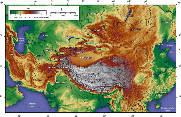 We should also not overlook the possibility of a similar economic integration between two large countries that are separated by the world’s other great mountain range, the Andes, namely Chile and Argentina. Unlike China and India, these two nations speak the same language. Their population centres, though separated by high mountains, are located quite close to one another. Chile’s largest city, Santiago, and Argentina’s fourth largest city, Mendoza, are only 175 km apart, as the crow flies. But they are separated from one another by mountains reaching over 5 km high.Greater integration between Argentina and Chile could help both to balance against their much larger, Portuguese-speaking neighbour Brazil. It could perhaps then allow (Ch)Argentina and Brazil work together towards a greater level of South American or Latin American economic or political integration. This could turn out to be as important as anything that might happen between East Asia and South Asia.
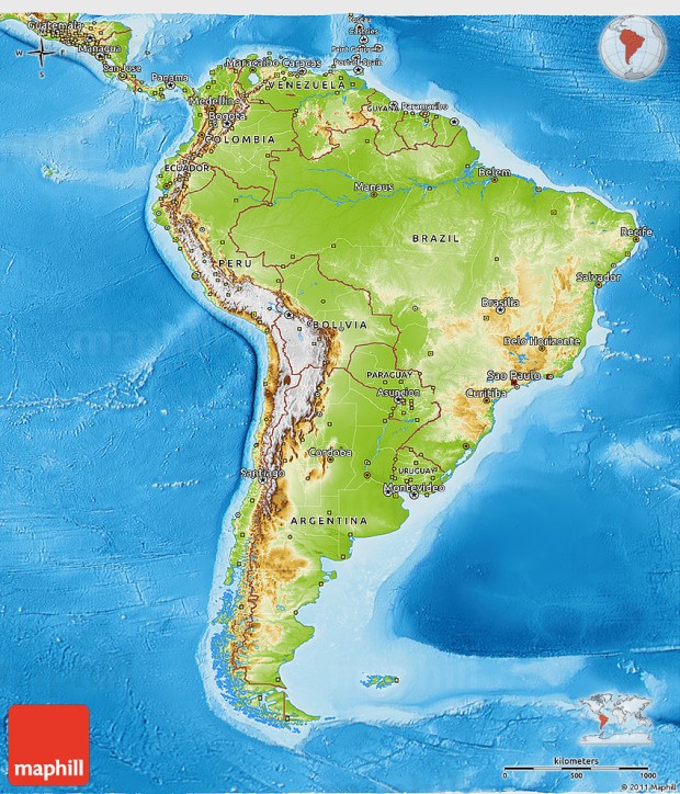 2. Return of the Mediterranean(s)
In our map of the world we saw the key position held by the Mediterranean, but also that the mountains of Mediterranean countries have limited their development as compared to the flatter lands like northern Europe and the eastern half of the United States. If, however, technology allows for economical transport in mountain areas, then the Mediterranean region might regain some of the influence it enjoyed historically.
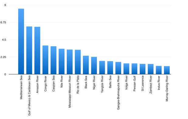
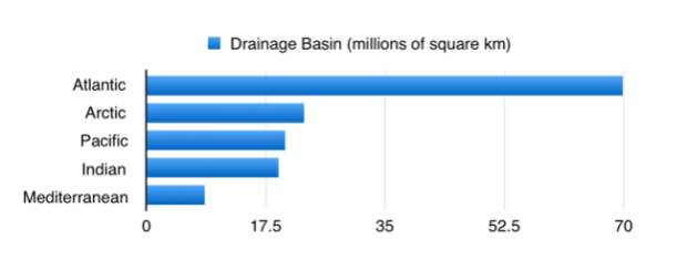
Drainage Basin (millions of square km) So too might other “mediterranean” seas that are surrounded in large part by rugged or rainforest lands. Most notable of these, perhaps, is the American mediterranean, the Gulf of Mexico & Caribbean, which, like the real Mediterranean, is centrally located (next to the narrow Atlantic, and between continents) but has much of its nearby population living in mountainous areas, in Mexico and Central America. The Caribbean, in turn, is near another “mediterranean” basin, the Amazon River and its many navigable tributaries.

3. The HeartlandWorks of “Classic Geopolitics”, notably Halford Mackinder’s book Democratic Ideals and Reality (which I recommend reading), written a century ago at the end of WW1, lays out a vision of the world that is somewhat similar to the one I have tried to describe here. It identifies Europe and the Middle East as the economically-geographically central spot in the world, and argues that, given the Middle East’s relatively arid climate (the Middle East and North Africa had a far smaller population relative to Europe in 1919 than it does today), and given the spread of railways into landlocked areas, it would be the vast flat lands of Eastern Europe that might give rise to a political entity potentially capable of dominating Europe, the Middle East, and by extension the “World-Island” (meaning the Asia-Africa-Europe supercontinent), and by extension the world as a whole.
In this view, the devastating German-Russian wars of 1914-1917 and 1941-1945 were about who would control East Europe; the Cold War, the 1917-1918 part of WW1 (when Russia left the war and the US entered it), the 1939-1941 part of WW2 (before the Hitler-Stalin pact was broken), the Russo-Japanese war of 1904-1905, or various conflicts during the 19th century, such as the Crimean War or the Anglo-Russian “Great Game” in Central Asia and the Middle East, were about peripheral powers (Britain, France, Japan, the US, etc.) preventing an East European power like Russia and/or Prussia from expanding its influence.
Regardless of whether or not this Mackinderian perspective is an adequate one, it does seem that the central position of Europe, Eurasia and the Middle East arguably really does exist, and may persist. Eastern Europe continues to house by far the largest state and population in this area (Russia), and the Germans still by far the largest economy. But the more mountainous states and populations in Iran, Turkey, Ethiopia, and much of the Mediterranean and/or Arab worlds are also large, oil-rich, and centrally located. How this story will unfold going forward is anyone’s guess.

