Iraqi Geopolitics

Iraq’s population is thought to be just under 35 million, roughly the same as that of Canada and greater than any other Arab country apart from Egypt, Algeria, and possibly Sudan.

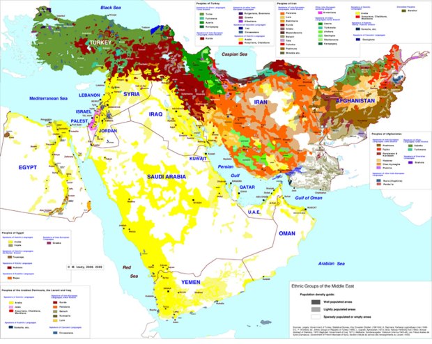
Most Iraqis, and almost all Iraqis who identify as Shiite Muslims, live in the low-elevation Mesopotamian plain, the part of the map below that is coloured in the darkest shade of green.

middle-east-topo-map-864

The only significant city to have a considerable Shiite population outside of this area is, perhaps, the city of Samarra, which is holy to Shiite Muslims. Yet Samara lies just barely beyond this Iraqi Shiite heartland, and is relatively small. It had 350,000 or so inhabitants prior to the US invasion of the country in 2003. In 2006 and then again in 2007 the Al-Askari Shrine, a mosque that was built in Samarra in 944 AD,  was bombed, leading Shiite groups in Iraq to retaliate by forcing many Sunnis to leave their homes in Baghdad.

Iraq-with-Ur-site-and-cities-OL

The largest cities in Iraq’s Shiite region are not located in the region’s centre, but rather around its outer edges. The largest by far is Baghdad, located in the north of the Shiite core region. Baghdad is perhaps 3-5 times more populous than any other city in Iraq; it may be home to nearly one in four Iraqis. It is maybe the most populous city in the entire Arab world, outside of Cairo. Historically it was the capital of an enormous caliphate, stretching from Central Asia nearly to the Atlantic Ocean, during most of the years between 762 AD and 1258 AD. Even as recently as the 1970s, before Iraq fought three major wars between 1980 and the present day, Baghdad was one of the leading cultural and commercial cities in the Arab world. 

4444256984_63246f5106_b

Baghdad has historically been the place where Iraq’s Shiite and Sunni areas meet, and where minority populations like Kurds, Christians, Jews, and Turkic peoples have all lived in significant numbers as well. Though the conflicts in Iraq during recent years and decades has changed this to a great extent, with many minorities leaving (the Jewish population, for example, has dropped from around 50,000 in 1900, which was perhaps a quarter of the city’s total population at the time, to nearly zero today) Baghdad remains the heart of the country.

baghdad

Baghdad’s existence has probably been one of the main impediments to, and arguments against, splitting the country into three separate states as many have recently been advocating for. However because of its diversity and centrality, it was also the site of many of the violent deaths during the (in some ways ongoing) civil war. Since 2003 the city’s neighbourhoods have become more divided by sect, while the share of its population that identifies as Sunni has shrunk in size due to the fleeing of Sunnis and the inward migration of Shiites from southern Iraq.

         Baghdad in 2003                    Baghdad in 2007

Baghdad_Ethnic_2003_sm   Baghdad_Ethnic_2007_late_sm

Baghdad’s geographic significance comes from being located in the only spot, apart from the swampy southern coastlands of Iraq, where the Tigris and Euphrates rivers come close to meeting one another. Around Baghdad the Tigris and Euphrates are just 30-40 km or so apart from one another, compared to about 150-200 km apart in most of southern Iraq, 120 km or so apart in the area to Baghdad’s immediate north, and 220-300 km apart in the northern Iraq-Syria region.

iraq 1.png

Baghdad is located 530 km from Iraq’s only coast (on the Persian Gulf), 450 km from Iraq’s border with Turkey, and 475 km from its western, desert border with Jordan. It is about 700 km from Tehran, 740 km from Aleppo and Damascus, 95o km from Riyadh, and 1300-1450 km from Mecca, Dubai, Cairo, Ankara, and Crimea.

iraq 2.png

Apart from Baghdad, the biggest Shiite city in Iraq, maybe even twice as populous as any other, is Basra. Basra is located in the only other place where the Tigris and Euphrates meet, just 95 km or so north of the coast of the Persian Gulf, and just around 20 km from the Iranian border and 40 km  from the Kuwaiti border. Because it is located just 4 metres above sea level (compared to 35 metres for Baghdad), Basra’s climate is an extremely hot one, with temperatures hitting average daily highs of around 40 degrees celsius (105-ish fahrenheit) for almost five months a year.

Could Basra soon have the world’s tallest building? 

818

The fact that this southernmost area of Iraq around Basra has the country’s only direct access to the sea, and that this access is funnelled narrowly and vulnerably through a strip of land that is only about 15 km wide, sandwiched between the oil-rich Arab monarchy of Kuwait and the oil-rich Arab-inhabited Khuzestan province of southwestern Iran, was probably one of the reasons why Iraq went to war against Iran throughout the 1980s and then attempted to annex Kuwait in 1990.

Grabbing Kuwait and Khuzestan would give Iraq unfettered access to the Persian Gulf, greatly increased oil resources, and a mountainous rather than wide open border with southern Iran. Kuwait alone, in spite of having a population of just 3.4 million, produces so much oil that its GDP is thought to be roughly 75% percent as large as that of Iraq itself, and 40% percent as large as Iran’s.

Iran_topo_en

nigelmaund102010A

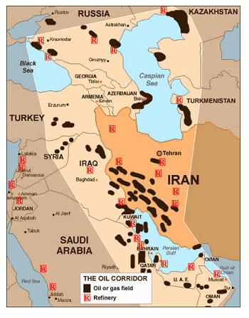
Today, however, it is not clear whether Kuwait and Khuzestan have majority-Arab populations as they likely did in the past. Two-thirds of Kuwait’s population is now thought by some to be foreign workers who have come to the country mainly from South Asia. Some have estimated that 30-40% of Kuwait’s Muslim population is Shiite, though it is difficult to be certain. Khuzestan’s population of 4-5 million, meanwhile, has perhaps become majority Persian; statistics cannot really be trusted in this area, given that they can be politicized.

The other largest cities of the Shiite region of Iraq also lie along the region’s edges rather than in its centre; they are located either along the Tigris River, as for example the cities of Amarah and Samarra are, or along the Euphrates River, as the world’s two holiest Shiite cities of Najaf and Karbala are.

karbala.png

The Shiite region of Iraq is divided, in a certain geographical sense, along both north-south and east-west lines. The north-south divide is between landlocked Baghdad and coastal Basra, the region’s two major cities, with Baghdad located close to its northern extreme and Basra close to its southern one.

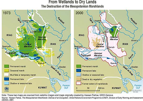
The east-west divide is between the Tigris and the Euphrates; the two rivers were historically separated from one another by marshlands in some places, which according to Wikipedia “used to be the largest wetland ecosystem of Western Eurasia” before being drained during the second half of the 20th century — mainly by the government of Saddam Hussein, for political reasons. “After the fall of Hussein’s regime in 2003, the marshes have partially recovered but drought along with upstream dam construction and operation in Turkey, Syria, and Iran have hindered the process”. The “Marsh Arabs“, formerly half a million strong, are themselves considered to be a unique Iraqi ethnic group.

marsh-map-hassan-partow-grid-geneva

The Euphrates directly borders the Arabian Desert (Basra, Najaf, Karbala, and Ramadi are each located on the Arabian side of the river), whereas the Tigris runs closely parallel with Iran’s Zagros Mountains, which rise to heights as great as in the Colorado Rockies or Swiss Alps. Given its topography, Iraq has rarely been able to project force into the Zagros (though Saddam Hussein tried to do so during the deadly Iran-Iraq war in the 1980s); the Iranians, on the other hand, have often been able to influence politics within Iraq and occasionally even invade Iraq directly.

Oshtoran_kuhj
The Zagros, in Iran’s Lorestan province near the Iraqi border

The division between Basra and Baghdad (such that it is) was seen to a certain extent in 2008, just prior to the US military withdrawal from the country, when the Shiite-dominated Iraqi government of Prime Minister Nouri al-Maliki approved a significant offensive mission by the Iraqi Army aimed at  pushing what was arguably the country’s main Shiite militia, the Mahdi Army, out of Basra.

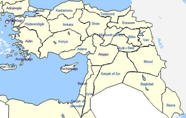
The Basra-Bagdhad divide goes back much further in history, however. Even when Iraq was ruled by the Ottoman Empire prior to the First World War, the country was divided into three administrative “vilayets”: Basra in the south, Baghdad in the centre, and Mosul in the north. The Ottoman era often saw the Europeans intrude into or make alliances with Basra, notably the Portuguese in the 17th century, and later the British. The British would return during the recent war: they were tasked with managing Basra while the Americans focused on other areas of the country.

OttomanVilayets-1900
Ottoman vilayets circa 1900

Iraq’s Sunni Arab region also contains both north-south and east-west divisions. It’s two largest cities by far are Baghdad, which is located at the southern tip of the Sunni areas, and Mosul, which is located just 100 km from Iraq’s northern Turkish border and is currently held by ISIS fighters. This is the basis of its north-south division; its east-west division comes from the Tigris and Euphrates being located much further apart from one another north of Baghdad than in the south (where, around Shiite Arab cities like Basra, Karbala, and Kut, the waterways almost or completely converge), with desert lying in between them.

According to Wikipedia, “The Arabic of Mosul is considered to be much softer in its pronunciation than that of Baghdad Arabic, bearing considerable resemblance to Levantine dialects, particularly Aleppan Arabic. …Mosul Arabic is heavily influenced by the languages of the many ethnic minority groups which co-exist in the city: Kurmanji Kurdish, the Shengali (Ezdiki) of Yazidis, Turkmen, Armenian, and Neo-Aramaic. Each minority language is spoken alongside North Mesopotamian Arabic.”

Arabic-Dialects-Map
You might want to take this map with a grain of salt

“…Before 2014 takeover by ISIS, Mosul population comprised roughly of 60% Sunni Arabs; 25% Kurds, 10% Turkmens and 5% Assyrian. Following the takeover by ISIS, nearly all the population who were not Sunni Arabs (coreligionists of ISIS), fled or forced out, that is, 35% of the residents or just over half a million people.”

Mosul, although not at a particularly high elevation, still receives much more rain than most of Iraq. Rainfall is close to three times that of Baghdad and over twice that of Basra”. Indeed, unlike the arid cities along the Euphrates, Mosul has a relatively  populous hinterland, as it is located next to the foothills of mountains both to its east and to its north. Mosul is just 75 km from Erbil, the comparatively successful capital city of Iraq’s Kurdish autonomous region. “After the 1991 uprisings by the Kurds Mosul did not fall within the Kurdish-ruled area, but it was included in the northern no-fly zone imposed and patrolled by the United States and Britain between 1991 and 2003″.

Hawler_Castle
The Erbil Citadel

Mosul is one of the two most important cities which lie on the border between Iraq’s Sunni Arab and Sunni Kurdish areas. The other is Kirkuk, which is less populous than Mosul but is where much of Iraq’s oil is produced. The oil in this Arab-Kurdish borderland has led to conflict during the past decade; and of course ISIS and the Iraqi Kurds continue to do battle today. According to the map below, both Mosul and Kirkuk (spelled Karkuk) are surrounded on three sides by the  Kurdish-inhabited territories, near to the mountainous Kurdish border regions of Turkey, Iran, and Syria.

 kurdish_lands_1992

Three months ago, the Turkish military entered northern Iraq and has closely approached Mosul . A month before that, according to Dexter Filkins of the New Yorker, “Kurdish forces, backed by American airstrikes, cut the highway that connected Mosul to the ISIS base in Syria. There are still a few roads leading into Mosul that ISIS can use to resupply its fighters, but the Kurds are moving to cut them, too. Very soon, the ISIS fighters inside Mosul will be isolated.” The Kurdish position has been complicated, however, by Kurdish-Turkish relations, which have partially deteriorated of late as a result of Turkish politics and the Syrian civil war’s effect on the Syrian Kurdish group the YPG/PYD.

Mosul is located along the Tigris River, north of the place where, in Syria, the Euphrates makes a sudden sharp turn westward towards Aleppo and the Mediterranean Sea. As such, unlike in most other cities in Iraq, Mosul sits at a spot where the Tigris and Euphrates are relatively far from one another (though still only 430 km apart). This has allowed Mosul to serve historically as a sort of oasis in the desert for east-west trade travelling between northern Iran (and Asia) and the Mediterranean (and Europe). Mosul sits almost exactly between Tehran and the Mediterranean, in fact. It is also located halfway between Basra and Russia’s southern border; in other words, between the Persian Gulf and the Black and Caspian seas.

pop dens

In late 2004 the US attack on Mosul was concurrent with the one on Fallujah, the latter battle arguably being the deadliest in the entire US-Iraq War. In 2014, six month prior to the ISIS seizure of Mosul (and Kurdish seizure of Kirkuk), ISIS “retook” Fallujah, which is just 40 km from Baghdad. ISIS also took control of the large dam upriver of Mosul, which according to Wikipedia has the fourth largest reserve capacity of any hydroelectric facility in the Middle East. Kurdish forces, with help from the US and Iraqi militaries, have since captured the dam.

Iraq’s Sunni Arab region, in spite of being relatively small in population because it is located in the desert, and also landlocked, has some advantages that Shiite Iraq does not. It has proximity to the Mediterranean, as well as access to the Mediterranean via the Euphrates which in Syria reaches as close to 200 km from it. The entire distance from the Persian Gulf  to any part of the Eastern Mediterranean coast, in fact, is only about 1300 km.
This Mediterranean access, however, is partly why the Shiite Iraqis and Iranians would prefer to keep Syria’s non-Sunni Assad government and Lebanon’s Shiite group Hezbollah in place, so as to block Iraq’s Sunni Arab minority and Syria’s Sunni Arab majority from working together to export Iraqi oil to the West via the Mediterranean and hence become powerful.

The Sunni Arab region’s upriver location, moreover, provides a potential advantage within Iraq as, especially towards the south, the country is often lacking in rainfall and dependent upon agriculture that can be devastatingly flooded by the actions of northern dams. In addition, because the Euphrates winds about a lot within the Sunni region (see map below), its cities can often be surrounded on three sides by the river and on the fourth by both the desert and the incline of the walls of the Euphrates Valley,  giving them a defensible position. A series of three lakes, finally, running 200 km from north to south, helps to divide Baghdad and southern Iraq from the Euphrates’ Sunni-inhabited northwest.

iraq_usmc-book_topo-map

It has become very popular to point out that Iraq’s borders, and particularly the Iraqi-Syrian border, are “artificial”, imposed on the region by the British and French in the aftermath of the First World War. This statement is not untrue, but nor is it necessarily as straightforward as many have come to believe.

Those saying that Iraq’s borders are artificial often ignore a number of facts. First is that, unless Syria, Iraq, Kuwait, and perhaps Lebanon are merged into a single state (a state which, given its position linking two oceans and containing the most oil anywhere outside of Saudi Arabia, could perhaps become the top power in the Middle East), or unless a united Kurdistan declares its independence in territories that are today part of Iraq, Syria, Turkey, and Iran (a declaration that could, and to an extent already has, led to war by those countries against Kurdish forces), then “artificial” borders must be drawn somewhere through the region.

Second, they ignore the fact that Iraq’s borders are actually not as random, geographically, as they are given credit for, as we discuss further below. Third, they ignore the fact that it is not only the West  that has been responsible for messing with the “natural” borders of Arab lands. Iran and Turkey, for instance, both refused to give up Arab-inhabited regions of the Fertile Crescent they possess; a more consistent geographic or cultural rendering of Middle Eastern borders should perhaps have included Turkey handing over its province of Hatay to Syria (as Syria still officially claims it should) and Iran handing over its province of Khuzestan to Iraq.

hataymap

And fourth, they often ignore the fact that the most “artificial” aspect of Iraq’s borders is not the fact that the borders themselves are drawn improperly, but rather is that Kuwait has been allowed to exist independently of Iraq at all. Why Kuwait, with its $53,000 per capita income, its nearly-autocratic monarchy, and its position that in effect walls-in Iraq’s only direct outlet to the ocean, should be allowed to maintain its political independence from Iraq remains a question, arguably, for those claiming that the real crux of Iraq’s problem is the “artificial” international borders between Iraq and Syria, or the lack of international borders between Sunni Arab Iraq, Shiite Arab Iraq, and Sunni Kurdish Iraq.

I am not saying that Kuwait should definitely be refolded into Iraq like Hong Kong and Macau were into mainland China or like Gibraltar may be into Spain. I am saying, though, that things may be a lot more complicated where borders are concerned than they are often acknowledged to be.

Iraq-Syria: The valley of the Euphrates is generally much wider on the Syrian side of the border than  on the Iraqi side of the border. Until the river gets close to Ramadi (the capital of Anbar province, by far Iraq’s largest by territory size) and Baghdad, where the river valley widens out again, the valley generally extends less than 100 meters out from either side of the banks of the river in Iraq, whereas on the Syrian side of the border it extends around 5000 meters out on average:

iraq-syria 1 .png

Zooming in on the border:

iraq-syria 2 .png

It is on the Syrian side of the border that the river cities of Raqqa, the “capital city” of ISIS, and Deir al-Zour, a Syrian provincial capital that has been fought over intensely by ISIS and Syrian military forces, are located. Notably, however, the entire Euphrates valley between Baghdad and Aleppo is actually barely larger in size than Rhode Island. The maps one sometimes sees in the media of “ISIS-controlled territory” are, for this reason, somewhat misleading, as in many cases they do not differentiate between desert and non-desert areas.

e47c7ca8a912570d969497513866377f_83032883_iraq_syria_control_ramadi_624


basra_3

The Iraqi-Syrian border was drawn in such a way as to give Syria all of the significant tributary of the Euphrates that meets up with the Euphrates just south of Deir al-Zour (see  map below), and to give Iraq all of the large, “lonely”mountain of Sinjar (lonely in that it does not link up with any other mountain ranges), which got attention earlier in 2015 as a result of a humanitarian crisis occurring there. You can see the mountain in the image below, west of Mosul and next to Syria’s border to the mountain’s west and north. Sinjar City, in the shadow of the mountain, had a population estimated at 90,000, mainly of the Yazidi religious and ethnic minority that groups like ISIS have deemed heretical or “devil worshippers”.

iraq-syria 1 .png

wEvacuation_graphicC

In Syria’s northeast the border with Iraq juts out eastward in order to allow the Tigris to very briefly serve as the border between the two countries. On the adjacent Turkish-Iraq border, however, the border swings back and forth from one side of the river to the other; it is a more “artificial” border, perhaps. The Iraqi-Jordanian desert corridor, meanwhile, is extremely artificial, yet it serves the useful purpose (in theory, at least) of giving Iraq a link to Jordan’s Red Sea coast or, via Israel, to the Mediterranean. Though it is across the desert, in which ISIS now has influence, Baghdad is just 785 km from Amman and 860 km from Jerusalem.

Finally, there is the Kurdish border. Though this border artificially divides Kurdish peoples from one another, with most Kurds living in Turkey (even though, from an ethnolinguistic perspective, Kurds are more similar to Iranians than to Turks or Arabs), the Kurdish borders between Iraq and Turkey and Iraq and Iran both adhere for the most part to the geographic barrier of the Zagros Mountains, as can be seen in the map below.

This does not mean that the Kurds do not “deserve a state of their own”, of course, but, given the height of these mountains, it does mean that border is hardly arbitrary. The Kurds have, in fact, many internal linguistic and political divisions themselves, reflecting the ruggedness of their mountain landscape; these internal divisions are not usually mentioned in the media outside of the Middle East, which has become generally pro-Kurdish.

Iraq_Topography.png


Kurdish
You might want to take this map with a grain of salt too

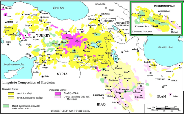
Still, Kurdish groups have, at least for the time being, been able to overcome their internal differences within the borders of Iraq. According to Martin Lewis of Stanford, “In constructing their own unrecognized state, the people of Iraqi Kurdistan have had to overcome deep divisions within their own society. In the mid-1990s, the region’s two main political groups, the Kurdistan Democratic Party (KDP), mostly representing the Kurmanji-speaking north, and the Patriotic Union of Kurdistan (PUK), mostly representing the Sorani-speaking south, fought a brief war. But although regional tensions in Iraqi Kurdistan persist, civil strife is no longer a threat. On both sides of the linguistic/political divide, most people have concluded that Kurdish identity and secular governance trump more parochial considerations. In the intervening years, the Kurdish Regional Government has managed to construct a reasonably united, secure, and democratic order”. 

2000px-Iraq_kurdish_areas_2003_vector

 Finally, here’s one last map for the road. It shows, again, just how complicated this region can be:

mapMEethnic.jpg


The Eternal Question


…Should I buy a treadmill?

According to Statista, wholesale consumer treadmill sales in the United States have fluctuated around one billion dollars per year since 2007; they dropped to 800 million dollars in 2009 after the recession and have gradually risen back up since. There are some reasons, though, why treadmills — or, perhaps, stationary bikes, ellipticals, rowing machines?, etcetera — could still be the “next big thing”:

home_category_treadmills
1. Headphones 

Treadmills, I don’t need to tell you, are loud. As you use them, people living in the same home or apartment as you are often annoyed by both their noise and their vibrations. If you use them while watching television, you will probably have to turn the volume on the tv way up, which will bother people around you even more. You may even be bothered by the loud noise yourself; indeed if you make a habit of going on the treadmill with the tv blaring at full volume, you may damage your ears in the long run.

Wireless headphones, then, could make treadmills much more appealing. And high-quality wireless headphones are for the first time going to be widely owned within the next few years — or months.

2. Netflix 

Sorry Wolf Blitzer, I don’t want to see your face ever again. From now when I am on the treadmill I am going to watch Netflix or last night’s Raptors or Warriors game (nobody tell me who won!). Hey, that actually makes exercising sound pretty good: it’s a great excuse for me to binge on tv.

3. Televisions

The year is 1995 and I am building an exercise room in my house. I decide to put a big tv in front of the treadmill, so I spend hundreds of dollars on a large television with a big behind, then a few hundred dollars more on a cabinet set to hold this voluptuous television. Wow, this is so expensive, and takes up too much space in this room! Maybe I should just wait until 2015, when I can get a 32 inch flatscreen LCD tv for less than $300 (down from $1600 in 2005) and mount it directly on the wall.

In fact, tv’s have now become so skinny that they can be attached directly to the exercise equipment. This could potentially allow people to move their exercise equipment outdoors in some cases, taking advantage of the space and fresh air in their backyards. Combined with wearing wireless headphones so as to not annoy one’s neighbours, this could make purchasing exercise equipment more reasonable.

4. Occulus!

Is virtual reality coming at last? Recently people have begun to believe that it is. If it does become advanced and widespread, then it may require a means to simulate movement in order to create a more dynamic virtual experience. Treadmills are an obvious candidate for such a simulation. Virtual reality may benefit from treadmills, therefore, and treadmills may benefit from virtual reality. Of course this might not actually end up happening, but it is worth speculating on nonetheless.

5. Fitbit 

Fitbit, the Apple Watch, Stepcounter apps, etcetera. Devices that let you know, in real time, what a lazy bum you really are could change the exercise industry in a big way. I know that I spend too much time sitting in front of a computer or television, and have been thinking about downloading a new app that has your phone alert you whenever you have been sitting down for more than an hour at a time. (I probably won’t download it, but I have been thinking about it!).

Many people have certainly been begining to use apps that show them how many “steps” they have taken every day, and in the spirit of self-competitive self-improvement have started to walk more in order to up their scores. This could, perhaps, lead to an increase in people purchasing treadmills.

 6. Millenials 

A large share of young people continue to live at home with their parents, or else on their own in small apartments or homes (often partially supported by their parents) where they do not have much space. As the large millenial population continues to age, however, they will depart from the nest, leaving behind bedrooms that can house exercise equipment. Some millennials will also be beginning to move into larger homes, where they may begin to buy equipment too. Or maybe not.

7. Real Estate

If you live in a 750 square ft. apartment space, then a typical high-quality treadmill will take up about 5 percent of your floor space. That’s no good; you will need more space in your home before thinking seriously about spending the $3000 or more that high-quality treadmills often cost. So, will indoor space in North America become cheaper?

It might, thanks to evolutions in transport (cheaper gasoline, hi-tech cars, Uber-style carpooling, driverless trucks, e-commerce with home delivery, etc.), communications (the modern Internet), and home construction (robots helping to build homes — it’s a scary thought, but get ready for it), which could make it easier for humans to spread out across cities, across suburbs, and across the countryside than ever before. E-commerce and e-commuting may also help bring home prices down by allowing some commercial real estate to be converted into residential.

8. Delivery

Good-quality exercise equipment tend to be among the more difficult-to-transport types of consumer goods. In most cases they are heavy, bulky, awkwardly shaped (and unable to fold up) and delicate. Getting them up a flight of stairs into a spare bedroom, or up many flights of stairs into an apartment building, can be a very difficult experience — and a costly one if you are employing delivery-men. If shipping and delivery-men become cheaper, then, it could be a boon to the industry, therefore.

Both, perhaps, can be expected. Delivery-men costs may fall as a result of the price of labour in general being squeezed by the double-whammy that is automation and outsourcing. Shipping costs, meanwhile, may fall because of cheap oil (if prices do not rise back up), falling labour prices leading to falling truck driver prices, innovations in trucking (smarter trucks, self-driving trucks, etc.), and the rise of the e-commerce and home-delivery industry (led, currently, by companies like Amazon).

If, moreover, self-driving trucks really do become commonplace, it could lead to much cheaper home delivery by allowing goods to be dropped off at local storage sites near the homes overnight while there is no road traffic, and then brought to the buyer’s home during the day.

9. Home Offices

Because of the Internet, in the years ahead many more people are likely to work from home, or from offices or coworking spaces close to home. This may free up time for people to go to the gym more often, lessening their need for things like treadmills. On the other hand, it may make people more likely to exercise at home, increasing their need for things like treadmills. Will it make people more likely to buy treadmills, on balance? I am not sure, but it is a possibility worth considering.

In addition, as home office spaces continue to shrink in size as a result of getting rid of fat desktop computers, printers, scanners, computer desks with pullout keyboards, and filing cabinets, and replacing them with more versatile laptops, tablets, and flatscreen desktops, there may be more space available in the home for treadmills.

10. Seasons 

In theory, treadmills should be seasonal goods: if you live in a place like Canada then you don’t really need one during the summer when you will probably prefer to exercise outdoors instead, and if you live in a place like southern California then you may only really need one during the summer when it is boiling outside. In practice, however, the high cost of shipping and delivering treadmills has prevented seasonal home rentals of treadmills, as has the fact that many people living in hot climates still do not have air conditioning and so do not want to work out indoors in the summer. 

The continued spread of air conditioning and the ability to more cheaply deliver treadmills, therefore, could perhaps lead to a situation where more people seasonally rent treadmills. In theory, at least, this could save people money as well as space in their homes. In fact, it may just be possible that long-distance shipping will eventually become cheap enough for a treadmill to become like the opposite of migratory bird, being used in a cold climate during the winter and then being shipped south to a hot climate for the summer.

——

On the other hand, there are reasons why such a treadmill “revolution” may not come to pass. But I am too lazy to discuss them right now; I think I will go for a long walk in front of Netflix instead.

The Not-So-Tiny Baltics — Image of the Day

When, in the media, the three Baltic states of Lithuania, Latvia, and Estonia are mentioned, usually in a sentence like “Russia may again threaten the tiny Baltic states, which unlike Ukraine are members of NATO and the EU”, they are frequently referred to as  being “tiny”.

This is certainly true of their populations: only 3 million people live in Lithuania, 2 million live in Latvia, and 1.3 million in Estonia. (If, however, you include the Russian Baltic enclave of Kaliningrad, which is located between Lithuania and Poland, or the Russian Baltic city of St Petersburg, which is between Estonia and Finland, there are an additional 5.5 million people). It is not nearly as true of the Baltics’ territory sizes, however: they are actually not so tiny, but only appear so because they are located next to much larger countries, most notably Russia.

Baltic_Sea_map

All three Baltic states have larger territories, for example, than the Netherlands, Denmark, Belgium, and Switzerland, countries which most people probably assume are bigger than they are. In per capita terms, moreover, the Baltics have quite a bit more land than other European states outside of neighbouring Scandinavia or the former Soviet Union. (The Baltics’ population densities are about the same as the United States’). And in terms of per capita arable land and per capita forested land, their lead over other European countries is even greater.

20150201063416

population density


Image of the Day – Germany at a Crossroads

Deutschland_topo

Germany, which accounts for an estimated 21% of the European Union’s GDP and has an unemployment rate that is less than half as high as the EU average, is now facing five big economic challenges:

1. Germany has one of the oldest populations in the world: it’s old age dependency ratio is as high as Greece’s and higher than any other country apart from Italy and Japan; the share of its population aged 80 or older is higher than in any European country apart from France or the “PIGS” (Portugal, Italy, Greece, and Spain). The largest portion of Germany’s population is between 45-60 years old. Old age is beckoning.

2. Whereas Britain, France, Italy, Russia, India, China, and Turkey depend on exports of goods and services to account for an estimated 20-30 percent of their GDPs, and the United States, Japan, and Brazil for just 10-20 percent, Germany gets approximately 46 percent of its GDP from exports. As economies throughout Europe and the developing world are simultaneously growing slowly right now, such a dependence on exports may not be a good thing to have.

3. Low energy prices are not likely to benefit Germany as much as many think, nor will they benefit Germany’s neighbours in northern Europe, central Europe, or especially the former Soviet Union too much (see links for more: herehere, or here). According to the Wall Street Journal, oil imports account for just an estimated 2.4% percent of Germany’s GDP, compared to 3-6% in Spain, Greece, Turkey, Poland, Japan, South Korea, Taiwan, and India, while, according to the World Bank, imports of energy in general account for approximately 62% percent of Germany’s overall energy use, compared to 70-95% in Spain, Portugal, Italy, Turkey, South Korea, and Japan.

4. Germany is facing economic and political diminishing returns in its eastward economic integration. In the past generation it has looked to East Germany and Eastern Europe, but Eastern European countries are no longer so cheap. Czech Republic and Slovakia now have nominal per capita GDP’s of around $19,000, for instance, up from just $5700 in the year 2000; Russia has reached $14,000, up from $1800 in 2000. Increasingly there are also political limitations of various sorts to German involvement to its east. Many Eastern European countries, for example, would rather not see the Germans and Russians become too close with one another economically, and also do not want to become German economic satellites themselves. Things may be becoming more politically fraught than they were a decade or two ago.

5. A similar dynamic is true of Germany’s domestic politics. In the 1990s Germans could unite over the goal of German reunification, while in the 2000s they could unite over European expansion into Eastern Europe, a region located for the most part directly on the borders of Germany or German-speaking Austria. Now, though, with both those goals having been realized to a large extent, there could be room for inter-German regionalism to become more prominent.

It has still been just 145 years since German unification, and 25 since reunification; the three-way divide between eastern Germany, western Germany, and southern Germany, aka Bavaria, may still be somewhat in play. This was seen recently, when Merkel’s longstanding political coalition finally came under pressure as a result of internal opposition from Bavaria over the refugee issue. Germany is under no threat of dissolution, obviously, but regionalism could nevertheless threaten the ability of its central government to continue forming majorities, and it could threaten the ability of any majority governments it does form to take decisive political action.

Germany’s parliament is already regionally split to a slight degree: the Christian Social Union in Bavaria, the regional sister-party of Angela Merkel’s national Christian Democratic Union, holds 7 percent of the seats in Germany’s parliament. Southern German states, moreover, in particular Bavaria but also neighbouring Baden-Wurttemberg, tend to be more right-wing in their voting patterns, whereas eastern German ones tend to be the most left-wing. (Here’s an article describing some of the geographical patterns in Germany’s 2013 election). Bavaria and Baden-Wurttemberg are the second and third most populous of Germany’s 16 states, and have the closest ties to Austria.

There may be other triggers as well for  regionalist challenges within Germany. If, for example, Europe’s banking and political system, which is currently under pressure from struggling economies like Italy, Greece, and France, ends up being badly damaged, it may hurt western or southern Germany more than eastern Germany. This is because Frankfurt (in central-western Germany) is Europe’s banking and transportation hub, and because southern Germany has relatively close connections with nearby northern Italy while western Germany is relatively close with France,  Belgium, and the Netherlands (the latter two being Europe’s political and shipping hubs). Of course, this is all extremely speculative; I am not actually saying that  political regionalism will reemerge within Germany, only that it cannot be ruled out.

The Crossroads

There are, perhaps, two basic roads Germany can now go down. One is to become a more nationalist, more insular country. German nationalism could be used as a tool to attempt to bring about cooperation in parliament. Germany could restrict immigration flows as most other countries (and Bavaria) have wanted to do. Germany could try to use technology rather than immigration to solve its looming old-age crisis. And Germany could attempt to overcome its dependence on exports by reorienting its economy: either by having the government buy up the surplus goods that Germany now exports to other countries, or else by producing fewer goods and attempting the difficult task of making money in other ways instead.

On the other extreme, Germany could become even less nationalist and even less insular than it is now — and it is already quite a bit less nationalist or insular than most other countries, as a result of its 20th century history and export-intensive economy. It could continue to welcome immigrants from places like Africa, Arabia, and Asia, which could help it to address its old-age problem and, along with the population of Turks and many other groups already living in Germany, would make Germany a globally diverse country, somewhat like Canada, Britain, and the United States are. Germany could continue to happily use the English language without being worried that this will threaten the German language, rather than move towards a linguistic protectionist model as countries like France often have. And Germany could continue to integrate economically with Eastern Europe, Russia, and Turkey, but become so non-nationalist in its identity that this expansion will not be as likely to create a political backlash.

Which direction will Germany choose? I suspect, regretfully, that it will be the former. Nationalism may simply be too difficult for a nation to overcome.


For more, read Germany’s Trade Empire


Image of the Day — Unique New York

Michael_R_BloombergMTE4MDAzNDEwMDU4NTc3NDIy

Last a month a report in the New York Times suggested that Michael Bloomberg, the mayor of New York City from 2002 until 2014, has been thinking about running for President of the United States as a third-party candidate, and may be willing to spend as much as a billion dollars of his own money to do so. Today, on the sole day between the end of football season and the start of ex-Iowa primary season, Bloomberg himself confirmed that report.

According to MarketWatch, this is “the first time Bloomberg himself has said he might run, though his surrogates have told other outlets the former New York City mayor and founder of Bloomberg LP was considering such a move. ‘I find the level of political discourse and discussion distressingly banal and an outrage and an insult to the voters,’ said Bloomberg”.

The Bloomberg strategy is a fairly simple one: first you take Manhattan, then you take D.C. The idea would be for him to secure huge amounts of donor money and media support available in New York City, as well as the 5.4% of America’s electoral college points that you get by winning New York state in the general election, and then use those assets in order to lure people outside of New York to vote Bloomberg on election day too, hoping that enough Americans will not want to vote for a non-centrist candidate like Donald Trump, Ted Cruz, or Bernie Sanders.

While it still seems quite unlikely that Bloomberg would attempt to pull this off, it cannot be ruled out entirely, in particular because of the following constitutional catch: if none of the candidates in the general election wins more than 50% of the electoral college votes, then the president of the United States is chosen instead by a state-majority vote in the House of Representatives, wherein the congressmen and congresswomen representing each state vote amongst themselves to determine which presidential candidate their state desires. The candidate which has the backing of a majority of states then becomes president, while the vice-president is chosen by the Senate.

In such a vote, Alaska’s one congressman would have as much power as all of California’s dozens of congressmen put together. This vote would probably favour right-wing establishment candidates, since most states and congressional districts in the country tend to be relatively right-wing, Congress is currently controlled by a Republican majority, and congressmen tend to be establishmentarians. If it ever came to this, then, a candidate like Bloomberg might have something of an advantage over one like Cruz, Trump, Sanders, or, perhaps, Clinton.

Could it ever come to this? Well, it did in 1824, when “four candidates ran for president… Andrew Jackson got the most votes from Americans and the most votes in the Electoral College, but not a majority, so the race was turned over to the House of Representatives voting as states who picked John Quincy Adams instead.” Crucially, if Bloomberg could secure a victory in New York state in the general election, that alone might make it relatively difficult for one of the other two candidates to win an electoral college majority.

If, for example, Jimmy Carter had lost New York in 1976 to a third-party candidate, Carter still would have gotten more votes than his Republican opponent Gerald Ford, yet would have fallen short of the electoral college majority needed to avoid turning the vote over to Congress. Had a third-party candidate won New York, Pennsylvania, and Iowa instead of Obama in 2012, Obama would not have won a majority in the electoral college, which would have meant that the Congress would have been able to vote to select the president of the country instead.

What Bloomberg’s public presidential mulling-over really indicates, then, is the enduring power of both the state and city of New York. This is actually not just a Bloombergnagian phenomenon: Hilary Clinton served as one New York state’s two senators from 2001 to 2009, Bernie Sanders was born and raised in Brooklyn, and Trump in Queens. (Even Chris Christie has influence over bridges that reach New York). For a while there was also some presidential buzz about New York’s current governor Andrew Cuomo, who’s father Mario was also a longtime governor of New York and came relatively close to becoming president in 1988 and 1992.

At this point, in fact, the only leading candidates who do not have ties to New York are those who have ties to Florida: Rubio is a Florida senator and son of Cuban immigrants, Jeb Bush used to be a Florida governor and is near-fluent in Spanish, Cruz’s father is from Cuba (though Cruz is himself a senator representing Texas), and Trump has usually lived in Florida when not living in Manhattan.

New York is also a somewhat peculiar state, politically. Though on the one hand it is the heartland of liberal America (along with California, of course), on the other hand it has politics that are in some ways quite Republican-esque. It has, for instance, groups that are strongly pro-finance (because a lot of its money and jobs come directly or indirectly from Wall Street), pro-Israel (because it is home to an estimated 26% of America’s approximately 6.8 million Jews …some of whom would also be happy to see Bloomberg or Sanders become the first Jewish president rather than see Hilary become the second Clinton president), and pro-security (because it has been the main terrorist target in America, not only on 9-11 but in many other cases as well).

New York also has a sizeable right-leaning “upstate” region, in which potentially significant shale energy reserves are located. Unlike in nearby states, such as newly gas-rich Pennsylvania, New York has not yet been allowed to develop these resources. Some upstate New Yorkers may therefore be hoping for a president who will support the removal of the fracking moratorium in the state, so that they too can participate in the regional shale bonanza.

1988_large

The last time New York voted for a non-Democratic candidate was in 1984 when, along with most of the other states in the country, it approved of a second term for Ronald Reagan. In the following election of 1988, however, New York was one of just 10 states, and the only populous state, to vote against George H. W. Bush, who had been Reagan’s vice president. Will New York vote against a candidate from the Democratic Party again in 2016? Probably not, but of course we will soon find out.


Image of the Day – Islands of the Atlantic

As a follow up to the post about Pacific islands from last month, I decided to make another chart showing islands in the Atlantic. This chart is not as extensive as the previous one, though; it only shows islands that have populations between 100,000 and 1 million. Also, it may be missing a couple of islands, or have population statistics that are already a bit outdated, so if you spot a missing island or a population mistake please post a comment about it below. And if you have a favourite Atlantic island, I would like to hear about that as well!

atlantic islands

Image of the Day – US States

pop dens

The graph above shows the population densities of the 19 states in America that have at least 6 million people living in them. (Of the other 31 American states, 20 have fewer than 3 million inhabitants, 14 have fewer than 2 million inhabitants, and 6 have fewer than 1 million inhabitants). The graph below also shows the populations of these states. As you can see, New Jersey stands out for its high population density and high population size, while Texas and Arizona stand out for their low population densities and high population sizes.

pop dens 2

On the other extreme, Alaska and Wyoming stand out for their low population densities and low population sizes, while Rhode Island stands out for its high population density and low population size. Even Rhode Island, however, which is the most densely populated state in the country apart from New Jersey (not counting Puerto Rico or Washington D.C.), is about 17 percent less densely populated than is New Jersey. Massachusetts is the third most densely populated, followed by Connecticut (not shown above) and Maryland.


Exceptional New Jersey…now that’s something you don’t hear every day.

Image of the Day – Now that’s a basin!

black-sea-map

Assuming this map is accurate, the areas it highlights are those in which rivers flow into the Black Sea. A number of things about this may perhaps be geopolitically noteworthy:

– some countries, most notably Ukraine, lie almost completely within the Black Sea basin, whereas others, most notably Poland, lie just beyond the borders of the basin. Others still, like Bulgaria, are neatly bisected by it.

– a number of important cities, such as Istanbul, Lviv (the largest city in western Ukraine,  with the exception of Odessa), and the capital cities of Bulgaria (Sofia), Belarus (Minsk), and Bosnia-Herzegovina (Sarajevo), are situated precisely at the outer edge of the basin. Ankara, the capital of Turkey, is almost at the outer edge of the basin, meanwhile.

– the easternmost areas of Ukraine have rivers that flow into Russia’s Don River, and a coastline located along the Russian-controlled Sea of Azov rather than along the open Black Sea. Given that eastern Ukraine is relatively hilly (which this map does not show well) and is a leading producer of bulk goods like coal which are expensive to transport via truck, this Russian-oriented riverine and maritime access of eastern Ukraine is especially notable.

– The two most important rivers within this basin, namely the Danube and the Dnieper, empty into the Black Sea only about 200 km apart from one another, as a result of the fact that the Danube turns sharply north just before it reaches the sea, while the Dnieper turns southwest.


Image of the Day — Changing Electoral Demographics

From America’s Internal Environmental Geopolitics:

As you can see from the graph below, the US immigration boom has increased steadily in recent decades, and took off in a big way around 1990. So, immigration to the US is to a certain degree actually a fairly recent phenomenon (ignoring the pre-WW1 immigration boom, which is practically ancient history at this point). In fact, most second-generation immigrants from the heart of the most recent boom are still just turning 18 around now. And even among those who have already turned 18, voting participation tends to rise with age.

USA-Immigration-Annual1

We already discussed the flipping of California from swing state to Democrat state, which was, at least in part, the result of inward internal migration from other parts of the US as well as external immigration to the state from Asia and of course from Latin America. More recently, immigration from Mexico has flipped the state of New Mexico, which voted for the Republicans in every presidential election from 1968 until 1992, but has now voted Democrat in every presidential election since (with the exception of 2004, when it voted for a second Bush term). In the 2000 election, in fact, New Mexico was surrounded by a virtual sea of red states (see map below), but still voted for the Democrats; it was the counterimage of New Hampshire in that election, which voted Republican but was utterly surrounded by blue states.

2000 US election map

Immigration from Latin America (plus internal migration of young liberals to the city of Denver) may also have led Colorado – the population of which is now 20-25 percent Hispanic – to go from voting for the Republicans in every presidential election but one from 1968 until 2008, to voting for Obama in both of his elections. A similar thing is probably true of Nevada (now 25-30 percent Hispanic, and with a huge amount of internal US migration to Nevada’s Las Vegas metropolitan area in the past decade), which has actually voted for the winning US president in every single election since after 1976 (most of which have been Republicans), and could be about to vote Democrat for the third election in a row in 2016.

Many Democrats also think it may just be on the verge of happening in Arizona as well (now 30-35 percent Hispanic, and with lots of people from across the US moving to Phoenix), which voted Republican in every single presidential election but one since 1948. In 1964, in fact, Arizona was the only Republican-voting state in the country outside of the “South” – see map below. While Arizona did not vote for Obama in either of his elections, it may be that it would have voted for Obama in 2008 had his opponent not been Arizona’s own John McCain. Arizona and Nevada both produce almost no fossil fuels.

1964_Electoral_Map

Immigration may also help the Democrats win the eastern states of North Carolina and Virginia, the 9th and 12th most populous US states, respectively, neither of which produce much fossil fuels. The populations of North Carolina and Virginia are both now around 10 percent Hispanic (in other words, far less than some states, but far more than many other states). The population of Raleigh, North Carolina has also been swelled by a very large amount of internal migration from across the country during the last decade, as has the population of the metropolitan area of the city of Washington. D.C., which extends into Virginia. In fact, the cities of Charlotte, North Carolina and Raleigh, North Carolina have had the US’s two fastest-growing Hispanic populations since 2000, and Washington D.C. was not far behind them. North Carolina had not voted Democrat since 1976 and Virginia not since 1964, but both voted for Obama in 2008 and Virginia voted for Obama in 2012 as well.

Even more importantly, many Democrats think these same trends are now working to help them secure some of the country’s largest states, most notably Florida. Florida has historically tended to vote for the Republicans more often than the Democrats, but voted for Obama twice (and may technically have voted for Gore over Bush in the contested 2000 election which saw a Florida recount, even when the governor of Florida at the time was Bush’s own brother Jeb). Florida’s population is now around 25 percent Hispanic, and in particular has seen a large amount of growth in its non-Cuban Latin American population and among younger Cuban generations. This demographic shift is probably significant, given that the original Cuban generation that has been prominent in Florida’s politics in recent decades tended to be relatively conservative politically, reflecting the fact that in many cases it was made up of middle-class and upper-class Cubans who had to leave Cuba following the Communist Castro takeover there. Florida too produces very little fossil fuels.

Illinois, which in recent decades has been a swing state that has tended to vote for the Democrats, has perhaps seen its Democratic base strengthen as well because of demographic changes. It is now more than 15 percent Hispanic. New Jersey, the 11th most populous US state, is a Democrat state that used to vote often Republican prior to Bill Clinton (and which the Republicans probably hope to retake, which may be a part of the reason why they have been considering choosing the current Republican New Jersey governor Chris Christie as their candidate in 2016), and it now has a population that is approximately 19 percent Hispanic.

Ohio, Pennsylvania, and Michigan, the three largest conventional swing states in the US apart from Florida, have also had fast-growing Hispanic populations in the past decade or so, though their overall Hispanic populations remain only about 3.5 – 7.5 percent of their total populations. (Michigan also had fast-growing immigration from Iraq during the past decade). On the other hand, these states have also seen some outward internal US migration of young voters to other states.

Finally, even Georgia, a firmly Republican state which is the 8th most populous state in the country, could perhaps soon flip to the Democrats, the result of having a fast growing Hispanic population (the 10th fastest-growing of any state since 2000, which now accounts for more than 10 percent of the state’s total population), a large, long-established African-American population (roughly 20 percent of the state’s total population), and some young, potentially liberal families moving to Atlanta (which was one of the US’s fastest-growing metropolitan regions during the 2000s). Georgia also produces very little fossil fuels.

The Geopolitics of Cheap Energy

Oil prices have fallen again: they are now at $29 a barrel for West Texas Intermediate crude and a similar price for Brent, their lowest since 2003. Natural gas, coal, and other commodity prices have also been dropping of late, in most cases. So: what will be the geopolitical consequences of cheap energy in general and of cheap oil in particular, all other things being theoretically held equal?

One consequence of cheap energy is the weakening, possibly, of four potential great powers: Russia, Brazil, China, and Mexico. While the media has understood the Russian and Brazilian half of this list – their economies are both estimated to have shrunk by 1-3 percent druring 2015, after all, which is difficult to miss – it has largely failed to register the Chinese and Mexican half. This is because it views China as being a leading oil, energy, and natural resource importer rather than as a resource exporter like Russia or Brazil, and because it views Mexico as merely a source of drugs, migrants, resorts, and cheap goods rather than as a potential great power.

China

China may be the world’s largest energy importer, but it is has also become its second largest energy producer, and as such only relies on energy imports for an estimated 15% of its total energy consumption, in contrast to 94% in Japan, 83% in South Korea, 33% in India, 40% in Thailand, and 43% in the Philippines. In 2014 imports of oil were equal in value to just around 2.4 % of China’s GDP, according to the Wall Street Journal, compared to 3.6% in Japan, 6.9% in Korea, 5.3% in India, 5.4% in Thailand, 4% in the Philippines, and 3.3% in Indonesia.

South Korea and Japan also imported more than two and four times more liquified natural gas, respectively – the prices of which tend to track oil prices more closely than conventional natural gas prices do – than China did. China’s LNG imports barely even surpassed India’s or Taiwan’s. China’s imports of natural gas in general, meanwhile, were less than half as large as Japan’s and only around 20% percent greater than South Korea’s.

China, furthermore, tends to import energy from the most commercially uncompetitive, politically fragile, or American-hated oil-exporting states, such as Venezuela, Iran, Russia, Iraq, Angola, and other African states like Congo and South Sudan. In contrast, Japan and South Korea get their crude from places that will, perhaps, be better at weathering today’s low prices, namely from Kuwait, Qatar, the UAE, and Saudi Arabia. Similarly, China gets much of its natural gas from Turkmenistan, Uzbekistan, and Myanmar, whereas Japan imports gas from Australia and Qatar and South Korea imports gas from Qatar and Indonesia.

China’s top source for imports of high-grade anthracite coal, and its third largest source for imports of coal in general, is North Korea. China has, in addition, invested capital all over the world in areas hurt by falling energy and other commodity prices, including in South America, Africa, Central Asia, Canada, and the South Pacific.

Another mistake the media makes is looking at China as if it were a country, rather than what it really is: both a country and a continent. Continents have internal, deeply-rooted regional divisions, and China is no exception. Its main divide is between areas south of the Yangtze River, which tend to be mountainous, sub-tropical, and dependent upon importing fossil fuels, and areas north of the Yangtze, which tend to be flat, more temperate, and rich in fossil fuels.

Northern China, stretching over 1000 km from Beijing southward to Shanghai on the Yangtze, is the country’s political heartland. It is densely populated and home to most of China’s natively Mandarin-speaking, ethnically-Han citizens. When compared to southern China, the north has historically been somewhat insulated from foreigners like the Europeans, Americans, and even Japanese. Beijing’s nearest port is roughly 5000 km away from Singapore and the Strait of Malacca; Hong Kong, in contrast, is only around 2500 km from Singapore and Malacca. Beijing is rougly 2600 km from Tokyo by ship, whereas Shanghai is just 1900 km from Tokyo and Taipei is just 2100 km from Tokyo.

Japan’s Ryukyu island chain and the Kuroshio ocean currents historically allowed for easy transport from Japan to Taiwan and the rest of China’s southeastern coast; the Japanese controlled Taiwan for more than three and a half decades before they first ventured into other areas of China in a serious way during the 1930s. Even today, Japan accounts for a larger share of Taiwan’s imports of goods than do either China or the United States.

Southern China has often depended on foreign trade, since much of its population lives in areas that are sandwiched narrowly between Pacific harbours on one side and coastal subtropical mountain ranges on the other. In northern and central China, in contrast, most people live in interior areas rather than directly the along the Pacific coast. These people in the interior generally did not engage in as much foreign trade, as in the past moving goods between the interior and coast was often limited by the fact that northern China’s chief river, the Huang-he, was generally unnavigable and prone to flooding northern China’s flat river plains, destroying or damaging roads and bridges in the process.

In southern and central China, by comparison, even people living far inland could engage with the coast by way of the commercially navigable Yangtze and Pearl Rivers, which meet the Pacific at the points where Shanghai and Hong Kong are located.

Northern China, however, was most directly exposed to the land-based Mongol and Manchu invaders who ruled over the Chinese for most of the past half-millenium or so prior to the overthrow of the Manchu Qing Emperor in 1912. Today the north continues to retain the political capital, Beijing, and a disproportionally large majority of Chinese leaders were born in north China — including Beijing-born Xi Jinping and Shandong-born Wang Qishan (a former mayor of Beijing) — in spite of the fact that most Chinese political revolutionaries, including Mao Zedong, Deng Xiaoping, Chang Kai-Shek, Sun Yat Sen, Zhu De, Ye Jianying, Hong Xiuquan, and famed writer Lu Xun, hailed from southern or south-central China.

Today, out of China’s seven Standing Comittee top leaders, only seventh-ranked Zhang Gaoli was born in southern China, whereas five of the seven were born in northern China and one, Premier Li Keqiang, was born in central China. Zhang Gaoli may in fact be the first person born outside of northern or central China in thirty years to have made it to the Standing Committee. He is also the only person currently in the 25-member Politburo born outside of northern or central China. Among the 11-man Central Military Commission, meanwhile, seven were born in northern China, while two were born in north-central China and two in south-central China. Out of the 205 active members of the Party Central Committee, fewer than 15 were born south of central China.

Indeed, the southern half of China, stetching from islands in Taiwan, Hainan, Hong Kong,  Xiamen, and Macau in the east to the plateaus of Yunnan, Sichuan, and Tibet in the west, is politically peripheral. It is home to a majority of China’s 120 million or so non-Han citizens (most of whom are not Tibetan or Uyghur, though those two groups recieve almost all of the West’s attention), China’s 200-400 million speakers of languages other than Mandarin, China’s tens of millions of speakers of dialects of Mandarin that are relatively dissimilar to the Beijing-based standardized version of Mandarin, most of China’s 50-100 million recent adopters of Christianity, and most of China’s millions of family members of the enormous worldwide Chinese diaspora.

Southern China is physically closer to Southeast Asia (a region with a huge Chinese minority population) and most of the populous areas of Japan, and further away from sparsely populated Mongolia or Siberia, than northern China is. The south’s Fujian province, in particular, is linguistically and economically close to Taiwan, while the south’s Guangdong province is close to Hong Kong. A large share of China’s GDP comes from the coastal areas of China from around Shanghai south to Guangdong, particularly if you include Taiwan as part of the country. Guangdong alone accounts for an estimated 10% of mainland China’s GDP and over 25% of its exports. This creates a somewhat unbalanced dynamic: China’s political periphery is also its economic centre.

As it happens, northern China produces almost all of China’s fossil fuels (particulary in and around Shanxi province, 300 km or so inland from Beijing, where a large share of China’s coal is mined and which has seen the biggest political shakeup of any province from Xi Jinping’s anti-corruption campaign thus far), whereas southern and central China, especially if you include the neighbouring economy of Taiwan as being part of China, account for most of China’s imports of energy. Taiwan, in fact, may be more dependent on oil imports than any other significant economy in the world. Falling energy prices may weaken the Chinese political heartland relative to its periphery, in that case. Whether or not this will generate any political instability going forward remains to be seen.

If (a big if) energy prices remain low for a sustained period, then the question of China’s future dependence on imported energy also becomes relevant, as does the question of the future dependence on imported energy of China’s most important neighbours. In that case, how dependent on energy imports will countries like China, Japan, and India be in a decade or two from now?

While it is impossible to know what the future will be like, it is not difficult to imagine that China will remain less dependent on energy imports than India and/or Japan during the years or decades ahead, as a result of India’s still-emerging economy and Japan’s still-roboticizing economy.

China is not likely to be a major adopter of energy-intensive robots, in per capita terms, because China has a far larger cheap labour force than any country in the world apart from India. Japan, in contrast, will likely help lead the robot revolution, as its labour force is expensive and aging rapidly. This could make Japan even more dependent on importing energy, as machines that are both highly mobile and capable of sophisticated computation require an enormous amount of energy to run — and indeed, one of their main advantages over human labour is that they can and frequently will be tasked to run 24-7,  without even taking any time off for holidays or sick days.

China is not certain to increase its energy imports nearly as much as less-developed economies like India, meanwhile, as the Chinese inudstrial sector is facing challenges as a result of its past generation of energy-intensive growth. China faces rising labour costs in its cities, a pollution problem, crowded transportation infrastructure, a US that is concerned with Chinese industrial power, and countries throughout the world afraid of China’s world-leading carbon emissions. In addition, China is located much further away from the Persian Gulf and Caspian Sea oil and gas fields than the Indians and other South Asians are, and so might have difficulty accessing them in a pinch.

China may also have to face industrial competition from resource-rich or capital-rich economies such as Australia, Norway, Canada, Qatar, Texas, and maybe even Hong Kong, which will perhaps be able to use energy-intensive robots of various kinds to build up their manufacturing sectors in spite of their small labour forces. This could make China’s industrial growth rate slip, which in turn might reduce China’s resource imports and thus prevent China from becoming the leading beneficiary of low energy and commodity prices.

Such a shift will be especially likely if the United States or European economies decide to enact tariffs on goods coming from places that generate power by using coal in inefficient ways, a prospect that has become increasingly likely as a result of America’s triple-alliance between environmentalists opposed to coal consumption, shale gas producers competing with coal, and energy companies trying to pioneer more expensive but cleaner ways of consuming coal. China may then have to focus on growing its service sectors instead of its energy-intensive industrial sectors.

Japan, lastly, might benefit from Russia’s energy-related woes more than China will. This is not only because the Chinese have to a certain extent often looked to Russia as an ally against the West, but also because the areas of Russia that China is close to are mostly irrelevant to China: they are landlocked, Siberian, and for the most part located far from China’s population centres. Pacific Russia, in contrast, located next to the Sea of Japan on the East Asian side of Russia’s Pacific mountain ranges, has a far more liveable climate than the continental Siberian interior, is home to a number of useful medium-sized port cities, and accounts for much of the oil and nearly all of the Russian natural gas exports to Asia — led by energy-rich Sakhalin Island, which is just 40 km away from Japan and was partly owned and inhabited by the Japanese prior to the Second World War.

Russia may, in fact, be somewhat better prepared to fight another border war with China like it did in 1969, which might not be too different than the many other wars Russia has fought around its own borders both prior to and since then, than it would be to face off against Japan again within its far-eastern, mountainous, archipelagic and peninsular Pacific region, as it did in 1905 and then during World War Two. Of course this does not mean Japan will attack Russia — though it has certainly toyed with the idea of making more forceful moves in the Southern Kuril Islands, which both countries claim as their own. Even the unspoken possibility of conflict, however, may help grant the Japanese leverage over Russia in negotiations relating to commercial or political issues.

Mexico 

Mexico is much more than just America’s messy basement. It has the world’s 11th largest population,14th largest GDP, and, because it is in the New World, its population is in many ways much more internally unified than those of most other large countries are. It also has important ties to the rest of the Spanish-speaking world, to the Latin-based world in general, and to the 35 million or so Mexicans in the United States in particular, most of whom live in states adjacent to the Mexican border. Mexico is the clear potential leader in the Spanish-speaking world: its population is bigger than those of Colombia, Argentina, and Venezuela combined, and its economy is about to surpass Spain’s. If you include illegal transactions, Mexico already has the largest economy in the Spanish world by far. Along with (or perhaps instead of) Portuguese-speaking Brazil, Mexico could potentially help Latin America to become one of the most prominent regions in the world during the decades ahead.

Mexico may not be a major beneficiary of low energy prices, for three general reasons. First, it is a net oil-exporting economy: oil exports accounted for an estimated 2.7% of Mexico’s GDP in 2014, and Mexico had been hoping to increase its oil and gas production since its president enacted widely-touted reforms in the country’s energy sector that year. Mexico is also often a relatively high-cost oil producer, and so may be forced to cede market share to more price-competitive producers in other countries.

Second, Mexico has ties – both existing ties and potential future ties – to other countries in Latin America, a region that is highly economically dependent on exports of energy and other natural resources. Most of the South American economy is already in or flirting closely with recession as a result of the commodity crash, which on the whole is probably not a good thing for Mexico.

Third, Mexico has ties to the southwestern United States, in the areas of America that were part of Mexico prior to the 1830s-1850s, most notably California and Texas where around 25 million Hispanic-Americans live today. Like Mexico itself, this part of the US is dependent on energy exports, led by Texas (a major producer of oil, gas, coal, wind power, solar power, and refined petroleum products: Texas produces approximately one-fifth of US energy and one-third of US crude oil) but also including the surrounding energy-producing states of Oklahoma, Colorado, New Mexico, Utah, Louisiana, Arkansas and the federally-administered oil-and-gas producing waters in the Gulf of Mexico.

Nearly all of the states with a high share of Mexican-Americans are either energy-exporting states or else, in the case of California, New York, Florida, and Arizona, have the lowest per capita energy consumption of any states apart from tiny  Rhode Island, Hawaii, and Connecticut.

Even California’s energy imports do not balance out Texas’s energy exports, because California is itself the US’s third largest oil-producing state, tenth largest energy-producing state, and has the fourth lowest per capita energy consumption; its energy imports are not as large as one might expect given the enormous size of the Californian economy. They might even shrink in the future, if the Monterrey basin shale resources are developed. California is also the largest agricultural producer in the United States (Texas is fourth), a big sector that can be hit by falling commodity prices as well.

Mexico has admittedly been benefiting from cheap gas prices brought on by Texas’s shale boom.  Mexican imports of US gas have nearly tripled since 2009, which has benefited the industrial sector in northern and north-central Mexico. This gas import growth might slow going forward, however, as America’s LNG export facilities may soon be coming online, LNG import facilities in both Europe and China are expected to be opened soon, and the Panama Canal expansion which will be finised this year may allow LNG ships to traverse the canal from Texas to Asia for the first time. As LNG allows US gas to be sold worldwide, Mexico’s import growth of US gas might slow down. In any event, Mexico is the 19th largest natural gas producer in the world, so even with increasing imports from the US it will not soon become a significant net importer of natural gas.

In the future, meanwhile, somewhat similar to China, Mexico’s industrial growth may not be as strong as most people expect, which could cause it to become less dependent on energy and other commodity imports relative to other countries. Mexico is currently a major industrial economy, the result of its large and cheap labour force and proximity to US consumers. As labour and other prices in northern and to a lesser extent central Mexico are becoming more expensive due to economic growth in these areas, however, Mexico’s industrial growth rate may slow. This is because central and especially southern Mexico are separated from the US by vast areas of mountainous deserts or jungles, making the north-south roads and pipelines through Mexico expensive to build, use, and maintain, as well as potentially vulnerable to groups like the drug cartels, indigenous peoples, or local governments. Southern Mexico resembles Central America more than it resembles northern Mexico.

Mexico may increasingly also have to face industrial competition from Cuba, which is the only other sizeable Hispanic country close to the United States; from Venezuela, if it too can finally mend fences with America and leverage its energy resources to industrialize; or from Canada and the US, if they try to use robots and other technologies to re-industrialize. If, finally, domestic politics lead the US to try to make the Mexican border more of a barrier, Mexico might have to industrialize less and stick more to the many other sectors of the diverse Mexican economy, which are less resource-intensive.

Europe 

There is a fourfold division in Europe, where energy and commodity imports are concerned. First is between mainland Europe, which is a major importer of energy and oil, and the regions surrounding mainland Europe (namely Scandinavia, the North Sea, the former Soviet Union, the Middle East, North Africa, western Africa, and the Americas), which are energy and commodity producers. Even the United States has now become such a big energy producer that its energy imports account for only around 15% of its overall energy consumption, a very low share in comparison to an estimated 62% in Germany, 71% in Spain, 77% in Italy, 46% in France, and 43% in Britain.

Second is between countries which use the Euro as their currency – Germany, Spain, France, Italy, Greece, Slovakia, etc. – which tend to be significant importers of oil or other commodites, and countries that do not use the Euro – Norway, Sweden, Switzerland, Britain, Denmark, Poland, Romania, Czech Republic, Ukraine, Belarus, Russia, etc. – which tend to produce a decent amount of oil, energy, or other commodities — or else, like Switzerland, have economies that are not energy-intensive and so may not benefit as much from cheap energy. (Switzerland, the 20th largest economy in the world, also relies on imports for just 52% of its energy, according to the World Bank, which is a lower share than in all but four of the 19 countries within the Eurozone). Admitedly there are a few exceptions to this rule: most notably Turkey, which imports a lot of energy but does not use the Euro, and Estonia and to a lesser extent the Netherlands, which produce a decent amount of energy domestically yet do use the Euro. Still, even the Netherlands is a major net importer of crude oil.

The third division is between countries that are in the European Union and European countries that are not in the European Union. This division is similar to the Eurozone one, except that states like Britain, Denmark, Poland, Romania, and Sweden — all of which are mid-sized energy or commodity producers – are in the European Union but do not use the Euro, which leave the continent’s major commodity and enegy producers of Norway, Russia, and Ukraine as more prominent outsiders. Turkey, meanwhile, is, unlike Russia, Switzerland, Norway, or Ukraine, a member of the quite important European Customs Union, though like them it is not part of the EU.

Finally, and in some ways most pertinently, there is a division between northern Europe and southern Europe. The further north you go, the less dependent the Europeans are on energy imports. Scandinavia and Russia are the furthest north: they are major energy and commodity producers. (Even the three Baltic states, which are generally assumed to be among the smaller countries in Europe, actually own far more land per capita – and especially forested land, which is crucial for feeding Europe’s sizeable wood-fuel industry – than any European countries to the south of them do).

These are followed by countries like Britain, the Netherlands, Romania, Ireland, the German economies, Poland, the Czech Republic, Slovakia, Hungary, Belgium, and northern France, which have economies that are also not too dependent on energy imports. (Like Switzerland, both Ireland and northern France have economies that are not at all energy-intensive, when compared to others).

In southern Europe, finally, there are the economies of Spain, Portugal, Greece, Italy, France-sans-Paris, Turkey, Cyprus, and Malta, which are highly dependent on imports of oil, natural gas, and energy in general. (While nearby Algeria remains a large energy-exporting state and Libya has energy-export potential, Morocco, Israel, Lebanon, and Jordan are highly dependent on energy imports and Egypt and Tunisia are both more or less energy neutral). Perhaps not incidentally, most of southern Europe has experienced an economic depression during the past eight years.

The biggest exception within southern Europe, meanwhile, is Italy, which produces more oil than France, Greece, Turkey, and Spain combined, slightly more oil than even Germany produces. This may in fact partly help to explain why Italy has been suffering a great deal of late, whereas the Spanish, Portuguese, and possibly even Greek economies might finally be on the mend. Even Italy is the world’s third largest gas importer, however, so as with Spain, Portugal, Turkey, and Greece, the Italians depend on imports from abroad to supply more than 70% of the energy they consume.

Turkey

Turkey is in the most interesting position of all when it comes to energy and geopolitics. It, along with its nearest European neighbour Greece, is a significant net energy importer; Turkey has a relatively energy-intensive economy and energy imports account for three-quarters of its energy consumption, while in Greece energy imports account for 60% of energy consumption. Oil imports in Turkey and Greece were estimated to be equal in value to 3.2% and 4.5% percent of GDP in 2014, respectively, both figures quite a bit higher than in most other countries within Europe.

Surrounding Turkey and Greece, however, is a ring of leading energy-producing regions: the Middle East, Russia, Ukraine, the Caspian Sea-Central Asia region, and North Africa. Even Turkey’s closest Western neighbours of note, namely Italy, Romania, and Austria, are not necessarily going to benefit much from cheap oil or cheap energy. Italy produces nearly three times as much oil as Turkey does, Romania produces nearly twice as much oil as Turkey and depends on energy imports for just 22% of its energy consumption, and Austria has the lowest oil-imports-as-a-percent-of-GDP of any country in the Eurozone. Even Israel, Cyprus, and Egypt have made major new energy discoveries of late, of natural gas within the Eastern Mediterranean.

In past years, Turkey has already seen many of its neighbours fall to shambles to one extent or another — first the Soviet Union, Yugoslavia, Lebanon, Algeria, and the Caucuses in the 1990s, now Iraq, Syria, Ukraine, Greece, Georgia, and Libya, among others. Further troubles in the regions surrounding Turkey, then, perhaps brought on by the falling price of energy, could create a serious power vaccum for the Turks to consider filling.

Turkey’s close-to-home rivals the Kurds, meanwhile, are also potential losers in a cheap energy environment. They produce a lot of oil in Iraqi Kurdistan, abut a number of hydropower facilities located within Turkey’s mountainous Kurdish regions where the headwaters of the Tigris and Euphrates rivers form, and possess ties in some cases to energy-rich Iran (as a result of the Kurdish population in Iran as well as the fact that Persians tend to be ethno-linguistically closer to most Kurdish groups than most Kurds are to either Turks or Arabs) or to energy-rich Iraq (as a result of the sizeable Kurdish population that lives in Iraq).

India 

India, like China, is both a major energy producer, the seventh largest in the world, and a major energy consumer, the third largest in the world. In India, however, oil imports were equal to 5.3% of GDP in 2014, compared to just 2.4% in China, while energy imports accounted for 33% of Indian energy consumption, compared to just 15% for China. And whereas in China the areas that benefit the most from cheap energy are located outside of the Chinese political heartland, in India the country’s political core territories — which are centred around India’s largest state by far, namely Uttar Pradesh (population 200 million), as well as parts of its neighbouring states like Bihar (India’s third largest state), Madhya Pradesh (5th largest), Rajasthan (7th largest), and Delhi (India’s capital city, population 17 million) — may benefit among the most in India from falling oil and energy prices.

Some of the other areas within India, on the other hand, such as parts of both Western India (which produces 75% of the oil from onshore fields in India, and which has close economic ties to the nearby energy-rich Persian Gulf) and Eastern India (which is where most of India’s coal and other commodities are produced or exported), might not benefit in the same way*.

[*when I say “benefit”, I mean it in the geopolitical sense of the term, not in the ethical sense. From an ethical point view, for example, the fall in energy and commodity prices is arguably great news for many of the people in Eastern India who were being exploited because of their coal and mineral wealth. Obviously, things like this are usually far more complicated in reality than can be captured in any single essay].

India’s geopolitical dream is of a prosperous, peaceful Indian Ocean basin in which it, by virtue of its size, diversity, and central location, would be far and away the most prominent and powerful country. In order to accomplish this India must have better relations with Pakistan, a country that has been backed by the United States as well as by fellow Muslim states like Saudi Arabia. With the Saudis and other Sunni Muslim countries hurt by cheap oil and energy prices, and with India’s traditional allies against Pakistan, namely the Russians and Iranians, hurt by cheap energy too, both India and Pakistan might perhaps be forced to rely more heavily on the Americans. If, then, the Americans decide to prioritize India-Pakistan peace-making as a way to maintain stability in South Asia and help to contain forces like China, Russia, and pan-Islamism, there may be some cause to be hopeful. Don’t be too sure though: there are plenty of reasons why India, Pakistan, and the United States might each find it difficult to pursue Indian-Pakistani or Hindu-Muslim reconciliation.

Within the wider Indian Ocean region, stretching 6000 km from Madagascar to Indonesia and 6000 km from Sri Lanka to Kerguelen, there is also some scope for careful optimism. In East Africa, from around Ethiopia south through the Great Lakes, most economies are not dependent on energy exports in the way that western African countries like Angola, Nigeria, Algeria, Congo, Gabon, and Equatorial Guinea are. Even South Africa, the world’s sixth largest coal exporter, is not nearly as dependent on energy exports as Nigeria, Angola, or Algeria are, and is a net importer of crude oil. Oman and Yemen, similarly, the two Arab countries with coastlines directly along the Indian Ocean, are not nearly as dependent on energy exports as other Arab countries like Saudi Arabia, the UAE, Qatar, and Kuwait are. They, especially Yemen, may also be leading importers of food.

In the eastern Indian Ocean, the Indonesian islands of Sumatra and especially Java (combined population: 195 million) tend to be energy-importing areas, in contrast to Indonesia’s Pacific islands like Kalimantan and, 3500 km to the east of the Indian Ocean, West Papua, which account for most of Indonesia’s energy production as Sumatra’s aging oil fields are declining. In Indonesia’s neighbour Malaysia, similarly, most oil production comes from around the Pacific island of Borneo, an island Malaysia shares with Indonesia and Brunei, rather than from the Malay Peninsula on the edge of the Indian Ocean where most of Malaysia’s population lives. Singapore, moreover, which is located roughly in between western Malaysia and western Indonesia, is the world’s 13th or 14th largest oil importer (it is roughly tied with Thailand, which is also located along the outer edge of the Indian Ocean); in spite of its small size Singapore now imports nearly twice as much crude oil as Indonesia and Malaysia combined export to the world.