Political Dynasties and their Discontents

G9510.20.indd

Political dynasties have always been a big part of human civilization, and today is no exception.

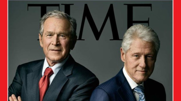
In the United States, the rise of Donald Trump was at least partially a reaction to the dynastic, Clinton-vs-Bush election that only last year most Americans were expecting to get.

It was, after all, Jeb Bush’s candidacy that split the Republican establishment in two, preventing it from coalescing around a politician like Marco Rubio early on and thus leaving an opening for Trump to force his way into. Hillary Clinton’s high disapproval rating, similarly, could even leave the door open for Trump to become president, however unlikely and unappealing that may be.

Canada

Jean-Chrétien-Justin-Trudeau-600x400
Former Canadian prime minister Jean Chrétien and Liberal Party leader Justin Trudeau wave at supporters at the University of Toronto, February 15, 2015 (William Pitcher)

North of the border, Canada has just elected Justin Trudeau as its Prime Minister, the son of Pierre Trudeau who was prime minister for fifteen years during the late 1960s, 1970s, and first half of the 1980s. One of Trudeau’s two opponents in the election had been NDP leader Thomas Mulcair, whose ancestors include the first and ninth Premiers of the province of Quebec.

Mexico

Enrique-Pena-Nieto-600x400.jpg
Enrique Peña Nieto, presidential candidate for Mexico’s Institutional Revolutionary Party, waves to supporters in the city of Torreón, June 18, 2012 (Flickr)

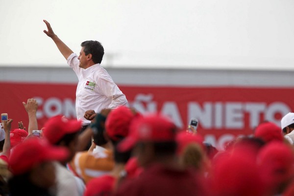
South of the border, Mexican President Enrique Pena Nieto,who came to power in 2013, “is the nephew of two former governors of the State of México (the state in which Mexico City is located): on his mother’s side, Arturo Montiel, on his father’s, Alfredo del Mazo González“, according to Wikipedia.

East Asia

168559_0.jpg
Japanese Prime Minister Shinzo Abe (left) and General Secretary of the Communist Party of China Xi Jinping (right)

In China, the current General Secretary Xi Jinping, who is now thought to have amassed more personal power than any Chinese leader since Deng Xiaoping, is the first to come from the “princeling” class. He is the son of a prominent political figure, Xi Zhongxun, from the first generation of the Communist Party leadership. This distinguishes him from the other General Secretaries in the Communist era, including Mao Tse-Tung, whose parents were not prominent politicians and in some cases were actually quite poor.

Other top members of the current Chinese leadership are also “princelings”, most notably Yu Zhengsheng, who is the fourth-ranked politician on the 7-man Politburo Standing Committee (which is generally considered to be China’s top political body), and Wang Qishan, who is ranked sixth on the Politburo Standing Committee and may be one of the most powerful figures in China at the moment as he has been leading Xi Jinping’s anti-corruption campaign . Wang is a princeling by marriage only: his wife is the daughter of Yao Yilin, who was a former Politburo Standing Committee member in the Communist Party.

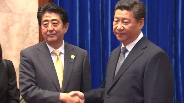
In Japan, Prime Minister Shinzo Abe is arguably the most powerful politician the country has seen in at least a generation as well. He too comes from a political dynasty. According to Wikipedia, “his grandfather, Kan Abe, and father, Shintaro Abe, were both politicians… Abe’s mother, Yoko Kishi,[3] is the daughter of Nobusuke Kishi, prime minister of Japan from 1957 to 1960. Kishi had been a member of the Tōjō Cabinet during the Second World War”.

Meanwhile the President of South Korea, Park Geun-hye, is the daughter of South Korea’s third president, Park Chung-hee. (Update: Park has since been impeached). (And in North Korea, of course, the Kim family’s rule is now into its third generation). In Singapore, the prime minister since 2004 has been Lee Hsien Loong, the son of Singapore’s modern founding father Lee Kuan Yew who served from 1959 all the way to 1990.

India

Hillary-Clinton-Sonia-Rahul-Gandhi-600x400.jpg
Hillary Clinton, then America’s secretary of state, poses for a picture with Indian Congress Party leaders Sonia and Rahul Gandhi in New Delhi, July 19, 2009 (State Department)

In India, Prime Minister Narendra Modi and his often fanatically right-wing Hindu nationalist BJP party became in 2014 the first party in over three decades to win a majority government in a national election. Modi is not from a political dynasty himself, rather he is the reaction to the modern world’s most prominent political family of all: the Nehru-Gandhi dynasty.

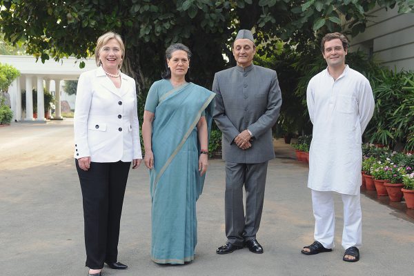
The Guardian wrote in 2007 that “the Nehru-Gandhi brand has no peer in the world — a member of the family has been in charge of India for 40 of the 60 years since independence.” The dynasty (which by the way is not related to the Gandhi) began with Jawaharlal Nehru, India’s first post-British prime minister from 1947-1964. Nehru was himself the son and nephew of significant political figures in pre-independence India. Nehru’s dynasty then continued with his only daughter Indira Gandhi (née Nehru), who was India’s prime minister from 1966-1977 and from 1980-1984, but was assassinated in 1984 by two of her own Sikh bodyguards in the wake of Operation Blue Star.

The dynasty was then followed by Indira’s sons Rajiv Gandhi, who was prime minister from 1984-1989 before being assassinated by the Tamil Tigers in 1991, and Sanjay Gandhi, who was expected to become prime minister but was instead killed in a plane crash. Rajiv’s wife Sonia Gandhi, meanwhile, is the leader of India’s powerful Congress Party and the mother of Rahul Gandhi, who lost to Modi’s BJP in 2014 but still finished with more parliamentary seats and far more votes than any other candidate in the election. Sonia likely would have run for prime minister herself, but cannot because she was born in Italy.

(Sanjay’s wife Maneka Gandhi, on the other hand, has jumped ship from the historically Gandhi-dominated Congress Party and joined the BJP instead; she is currently a cabinet minister in the BJP-led government. Maneka’s son Varun has also gone over to the BJP, serving as the youngest National Secretary in the history of the party and a member of the country’s parliament. However, Maneka and Varun both remain less prominent than the Congress side of the family, which is led by Maneka’s sister-in-law Sonia and Varun’s first cousin Rahul).

Arguably, frustration with the Gandhis directly paved the way for Modi, a man who was not even allowed to enter the United States prior to becoming president because he was allegedly involved in “severe violations of religious freedom” while serving as governor of the important Indian state of Gujarat.

Philippines

Rodrigo-Duterte-Benigno-Aquino-600x400.jpg
President-elect Rodrigo Duterte of the Philippines speaks with his predecessor, Benigno Aquino III, in Davao City, March 6, 2013 (Malacañang Photo Bureau/Ryan Lim)

You may have also heard about the election of the Philippines ridiculous new president Rodrigo Duterte last week. Rodrigo’s father Vicente was a provincial governor of Davao province and a mayor of Cebu, one of the largest cities in the country. Rodrigo’s cousin was also a mayor of Cebu, in the 1980s.

The Duterte’s are hardly alone in their political dynasticism: according to Public Radio International, “in the Philippines, elections in 2016 will be dominated by dynasties. About two-thirds of the outgoing Congress are heirs of political families. The outgoing president is the son of Corazon Aquino, who led the uprising against the dictator Ferdinand Marcos after Marcos had her husband whacked for being a prominent political opponent. But the Marcos clan is back in the picture, with Ferdinand’s wife, son, daughter and nephew all running for different offices. Also running is the grandson of another president.”

Thailand

Yingluck-Shinawatra1-600x400
Thai prime minister Yingluck Shinawatra addresses the United Nations Human Rights Council in Geneva, Switzerland, September 9, 2013 (UN/Jean-Marc Ferré)

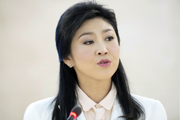
In Thailand too there has been a political reaction against a political family, that of Thaksin Shinawatra (who was prime minister from 2001 to 2006 before being exiled by a military coup) and his younger sister Yingluck Shinawatra (who was prime minister from 2011 to 2014 before being removed by decree of the Constitutional Court during the Thai political crisis in 2013-2014). According to Wikipedia, the father of Thaksin and Yingluck “was a member of parliament for Chiang Mai. [The Shinawatras are] a descendant of a former monarch of Chiang Mai through her grandmother, Princess Chanthip na Chiangmai (Great-great-granddaughter of King Thammalangka of Chiang Mai).”

Europe

Matteo-Renzi-Mariano-Rajoy-600x400.jpg
Prime Ministers Matteo Renzi of Italy and Mariano Rajoy of Spain speak during a European Council meeting in Brussels, June 25, 2015 (La Moncloa)

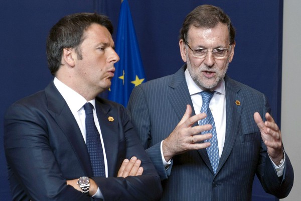
Europe, at least in contrast to Asia, does not have many political dynasties at the moment. This is, perhaps, in part because European political history was reset to a certain degree following the fall of the Soviet Union. Europe’s leading politicians, including Merkel, Putin, and Erdogan, do not come from political dynasties. Neither does Britain’s Prime Minister David Cameron (though his ancestors were extremely wealthy) or France’s President Francois Hollande. Italian Prime Minister Mattio Renzi’s was a municipal councillor, admittedly, but that does not really count. (Angela Merkel’s grandfather was, similarly, a local politician in Danzig). Spanish PM Mariano Rajoy’s family was fairly prominent, on the other hand.

That said, Europe is far from dynasty-free. According to the Economist, “in Europe family power is one reason why politics seems like a closed shop. Fifty-seven of the 650 members of the recently dissolved British Parliament are related to current or former MPs. François Hollande, France’s president, has four children with Ségolène Royal, who ran for the presidency in 2007. Three generations of Le Pens are squabbling over their insurgent party, the Front National (see article). Belgium’s prime minister is the son of a former foreign minister and European commissioner. The names Papandreou and Karamanlis still count for something in Greece.”

Syria and Egypt 

Assad-family-600x400.jpg
Syrian dictator Hafez al-Assad and his family in the 1990s (Wikimedia Commons)

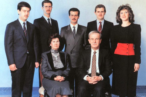
The Arab world remains full of political dynasties and reactions against dynasties, in contrast. In Syria both of these factors can be seen at the same time, as the civil war threatens to unseat Bashar al Assad, son of thirty-year ruler Hafez al Assad. (Bashar’s brother Bassel was initially supposed to take over from his father, but died in a car accident in 1994). In Egypt, meanwhile,the military government of Abdel Fattah el-Sisi is in some ways a response to the presumed attempt by an elderly Hosni Mubarak (diagnosed with stomach cancer in the same year he was deposed) to pass on power to his son Gamal, who had not served in the Egyptian military as Hosni Mubarak and previous rulers Anwar Sadat and Gamal Abdul Nasser had done.

Saudi Arabia 

Salman-bin-Abdulaziz-Al-Saud-600x400
Prince Muhammad bin Nayef speaks with King Salman bin Abdulaziz Al Saud of Saudi Arabia in Riyadh while Ambassador Adel al-Jubeir looks on, January 27, 2015 (White House/Pete Souza)

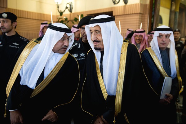
In Saudi Arabia, which is by far the largest Arab economy, a half-shift from one Saudi political dynasty to another may just be getting under way. Thus far in the history of the modern Saudi state (beginning around 1930), the country has been ruled either by founder Abdulaziz ibn Saud or else by one of his 45 or so sons, six of whom have become king, most recently King Salman who took the throne in January of 2015.

Last year, however, Salman removed his half-brother Muqrin (another son of Abdulaziz) from the office of Crown Prince, replacing Muqrin with their nephew Mohammad bin Nayef,  who would become the first king in the next generation of Saudi royals if ever takes over. He might never take over, though: many people now believe that is Salman’s own son Mohammad bin Salman, who is the Deputy Crown Prince and Defence Minister, who is the likeliest to become the next king when Salman (who is 80 years old) steps down or passes away, even though Deputy Crown Prince is formally a lower-ranking position than Crown Prince – and even though Mohammad bin Salman is only 30 years old, which would be an extremely young age for a modern Saudi king.

If Mohammad bin Salman does become king over another prince like Mohammad bin Nayef, Saudi Arabia could in effect be moving from a dynasty of Abdulaziz to a dynasty of Salman. There are now fears that the political situation in the country could become quite messy if the other branches of the huge Saudi royal family try to avoid becoming sidelined from power as a result.

Iran

Ali-Larijani-Hassan-Rouhani-Sadeq-Larijani-Mohammad-Golpayegani-600x400
Iranian president Hassan Rouhani speaks as parliament speaker Ali Larijani, Chief Justice Sadeq Larijani and the chief of the supreme leader’s office, Mohammad Golpayegani, attend a ceremony in Tehran, October 3, 2015 (Reuters)

Across the Gulf, in Iran, dynasties are not too big a factor within the current religious government. Recently the grandson of Ayatollah Khomeini even was blocked from participating in elections. One big exception to this, however, is the powerful Larijani family, made up of five brothers in key positions in the government. It includes Ali Larijani, who is the Speaker of the parliament and a former member of Iran’s Revolutionary Guards, and Sadeq Larijania, Iran’s Chief Justice.

Israel

3316639131
Labor party leader Isaac Herzog (left) and Yesh Atid party leader Yair Lapid (right)

A number of leaders in Israel hail from political families as well. Benjamin “Bibi” Netanyahu, who has now spent more time as prime minister (from 1996-1999 and now again since 2009) than any politician in Israel’s history apart from Israel’s founding  prime minister David Ben Gurion (who Netanyahu will soon overtake), is the son of Benzion Netanyahu. Benzion was a professor of history at Cornell University, an influential Zionist activist and magazine editor, and personal secretary to one of Israel’s most prominent founding fathers, Ze’ev Jabotinsky.

Bibi is also the younger brother of Yonatan Netanyahu, who was the unit commander of and only person to be killed during the famous Operation Entebbe raid in 1976, when 100 or so Israeli commandos rescued 102 hostages of a Palestinian airplane hijacking (compared to 3 hostages killed) from where they were being held in Idi Amin-era Uganda more than 3000 km south of Israel, and returned them safely to their homes in Israel and France.

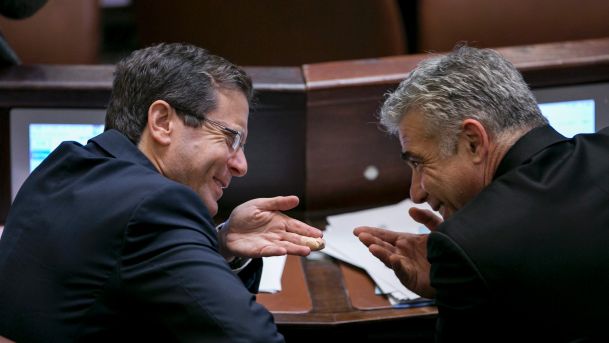
Israel’s Labour Party leader Isaac “Bougie” Herzog, meanwhile, who won more than twice as many votes as any other Jewish party apart from Netanyahu’s Likud Party in the most recent elections of 2015, is, according to Wikipedia, “the son of General Chaim Herzog, who was the Sixth President of Israel from 1983 to 1993, and the grandson of Rabbi Yitzhak HaLevi Herzog, was the first Chief Rabbi of Ireland from 1922 to 1935 and Ashkenazi Chief Rabbi of Israel from 1936 to 1959″.

The next largest Jewish political party after Labour and Likud is the Yesh Atid Party, led by Yair Lapid. Lapid is a former news anchor who is the son of Yosef “Tommy” Lapid, a former government minister, parliamentary leader of the opposition as recently as 2005, and radio and television personality.

Brazil 

Aécio-Neves-600x400
Brazilian Social Democracy Party leader Aécio Neves answers questions from reporters, May 28, 2015 (Agência Senado/Pedro França)

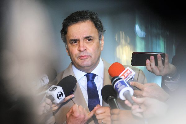
Leaving the Middle East, Brazils’ Aecio Neves, who in late 2014 very narrowly lost a presidential election to Dilma Rousseff (who may now be on the verge of being impeached herself), is the grandson of Tancredo Neves, who would have been President of Brazil in 1985 if he had not passed away before taking office. Roussef and her influential predecessor Lula da Silva are not from prominent political families, however.

Peru

Keiko-Fujimori-600x400.jpg
Peruvian presidential candidate Keiko Fujimori campaigns for the 2011 election, December 7, 2010 (Flickr/Keiko Fujimori)

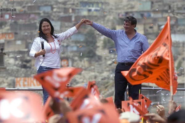
In Peru, the country is in the midst of a presidential election, which is a two-round system that began in April and will end on June 5.  Its leading candidate is former First Lady Keiko Fujimori, a daughter of former Peruvian President Alberto Fujimori. Alberto exiled himself to Japan following corruption and human rights violation scandals at the end of his ten yeas in power in 2000, but was later arrested in Chile in 2005 and is now serving a prison sentence back in Peru.

Argentina

Cristina-Fernández-de-Kirchner-600x400
President Cristina Fernández de Kirchner of Argentina speaks in José Amalfitani Stadium, Buenos Aires, April 27, 2012 (Presidency of Argentina)

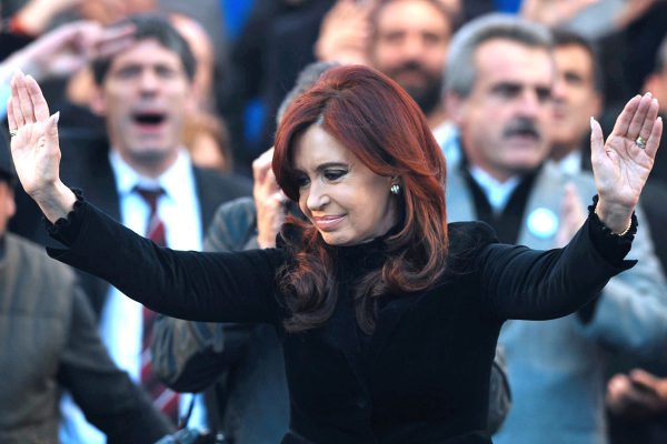
Argentina, finally, has just recently ended sixteen consecutive years of being presided over by a Kirchner, first by Nestor Kirchner from 2003 to 2007 and then by Cristina Fernandez de Kirchner from 2007 until the end of 2015. The Kirchners were Peronists, a political movement of sorts that has dominated modern Argentine politics, which is named for another power couple, Juan Peron (president from 1946 – 1955) and his second wife Eva Peron, who was a significant political figure in her own right and nearly became Vice President. (Juan’s third wife Isabel Martinez de Peron, meanwhile, was President of Argentina from 1974 to 1976). The incoming Argentine president Mauricio Macri, who is replacing the Kirchners, does not come from a political dynasty, however. His father was just a humble business tycoon.

Arable Land in Europe — Image of the Day

Arable land, in and around Europe:

Arable Land Stats in and around Europe
From the World Bank: “Arable land (hectares per person) includes land defined by the FAO as land under temporary crops (double-cropped areas are counted once), temporary meadows for mowing or for pasture, land under market or kitchen gardens, and land temporarily fallow. Land abandoned as a result of shifting cultivation is excluded.”

Arable land per capita

Of course, not all arable land is of equal value.

Here’s zooming in on the lower half of the graph:

arable land per capita zooming in

These graphs could be incorrect, though. The data used to make them came from this source (which does not show per capita stats), which seems to have come in turn from the World Bank. But if you look at more recent per capita World Bank data presented here you will see that, although the order of countries is generally pretty similar to graphs shown above, countries like Iceland, Libya, Algeria, and Ireland are no longer at the top.


Seniors Discount? Oil Prices and Old Rulers

Today’s low oil prices are probably not the result, even in part, of elderly men ruling over the world’s major energy-exporting nations. Still, it may be worth noting that the sons of Saudi Arabia’s modern founder, Abdulaziz bin Saud, are finally nearing the end of their long royal lifespans, while the leaders of energy-endowed countries like Iran, Algeria, Angola, Oman, Kazakhstan, and Uzbekistan have now reached old age too, after multiple decades in office. Even Vladimir Putin is 63 years old, long past his judo prime. He was just 47 when he first came to power.

As Egypt’s Hosni Mubarak and Libya’s Moammar Gaddafi arguably showed in 2011, longtime aging rulers can sometimes give way to political upheaval that causes domestic oil and gas production to fall. Uncertainty over the vigour of some of the following leaders might indeed cause global energy exports to fall, and thus, perhaps, prices to rise:

Kuwait – Sabah al-Ahmad al-Jaber al-Sabah – 86 years old – In power since 2006  

Sabah’s presumed successor, Nawaf Al-Ahmad Al-Jaber Al-Sabah, is 78 years old. As recently as 2012 Kuwait was the world’s largest oil exporter outside of Russia and Saudi Arabia.

Saudi Arabia – Salman bin Abdulaziz bin Saud – 80  years old – In  power since 2015 

Salman will probably be the last king to be chosen from among the 45 or so sons of the founder of modern Saudi Arabia, Abdulaziz bin Saud. Salman’s youngest living sibling, his half-brother Muqrin, is turning 71 this year and, as of last year, is no longer the designated  Crown Prince. The Saudi Crown Prince has since become Muhammad bin Nayef, Salman’s nephew, while the Deputy Crown Prince has become Salman’s own son Mohammad bin Salman

Algeria – Abdulaziz Bouteflika – 79 years old – In power since 1999 

Bouteflika came to power during and after the Algerian Civil War of the 1990s. Today his health is in question. Algeria is estimated to be the world’s 16th largest energy producer and its fourth largest natural gas exporter.

Uzbekistan – Islam Karimov – 77 years old – In power since 1991  

Karimov first came to power at the end of 1980s, when he became President of the Uzbek Soviet Socialist Republic

Iran – Ali Khameni – 76 years old – In power since 1989 

Kazakhstan – Nursultan Nazerbayev – 75 years old – In power since 1991 

Oman –  Qaboos bin Said al Said – 74 years old – In power since 1970

Qaboos first became ruler  after overthrowing his father in a palace coup in 1970. He has no children or clear successor

South Africa – Jacob Zuma – 74 years old – In power since 2009 

Zuma was Deputy President of South Africa from 1999-2005. South Africa is a major producer of energy, and a net exporter of energy, because of its coal reserves, though it is a net importer of oil

Nigeria – Mohammadu Buhari – 73 years old – In power since 2015 

Buhari was previously Nigeria’s head of state during the 1980s

Angola – Jose Eduardo dos Santos – 73 years old – In power since 1979 

Angola, one of the fastest-growing economies of the past decade, is now the world’s third or fourth largest oil exporter outside of the Middle East

Equatorial Guinea – Teodoro Obiang Nguema Mbasongo – 73 years old – In power since 1979 

Equatorial Guinea is the 30th-40th largest oil producing country, but may have the world’s third highest per capita oil production, the highest outside the Middle East.  Both the age of its leader and the number of years he has been in power are exactly the same as in Equatorial Guinea’s relatively nearby neighbour Angola

Sudan – Omar al Bashir – 72 years old – In power since 1993

Brunei – Hassanal Bolkiah Muiz’zaddin Wad’daulah — 69 years old – In power since 1967

Brunei is the world’s 40th-50th largest oil producing country, but may have the 6th highest per capita oil production

Brazil – Dilma Roussef – 68 years old – In power since 2010

Her predecessor, Louis Inacio Lula da Silva, who literally as of today was selected to  become Roussef’s new chief of staffwas 65 years old when he left office in 2011 at the end of an eight-year term. Roussef has been facing an impeachment attempt, while Lula has been under investigation in a corruption scandal. 

United Arab Emirates – Khalifa Al Nayhan — 68 years old  – In power since 2004

The Emir of Dubai is 66 years old, meanwhile

Colombia – Juan Manuel Santos – 64 years old – In power since 2010 

South Sudan – Salva Kiir Mayardit – 64 years old – In power since 2011

Iraq – Haider al Abadi – 63 years old – In power since 2014 

Masoud Barzani, meanwhile, who has been president of oil-rich Iraqi Kurdistan since 2005 and leader of the Kurdistan Democratic Party since 1979, is 69 years old. Foud Massoum, a Kurdish politician who is Iraq’s president (a more ceremonial role than prime minister), is 78 years old and has been in office since 2014. Nouri al Maliki, who was Iraq’s prime minister from 2006-2014 and is now Iraq’s vice president, will turn 66 this June. Saddam Hussein was 42 years old during his purge of 1979 and 66 years old when the US invaded in 2003.

Russia – Vladimir Putin – 63 years old – In power since 1999

Malaysia – Najib Razak — 62 years old – In power since 2009

Mahatir Mohammad, meanwhile, is 90 years old. Malaysia is thought to be the world’s 25th largest oil producing country

Turkey – Recep Tayyip Erdogan – 62 years old – In power since 2003

While Turkey is a significant net importer rather than exporter of energy, it is nevertheless capable of impacting the rest of the Middle East, and it has hopes to become a major energy nexus at the centre of the Middle East, North Africa, and Caspian Sea region. (Similarly, Israel’s Benjamin Netanyahu, who has been prime minister since 2009 and was previously prime minister from 1996-1999, is 66 years old)

Australia – Malcolm Turnbull – 61 years old – In power since 2015

Egypt – Abdel Fathah al-Sisi — 60 years old –  In power since 2014 

Sisi was also highly influential for at least a few years before 2014, following Hosni Mubarak’s departure from office in 2011

The following graph shows how old these countries’ rulers were in any given year between 1970 and 2015, and how old they will be in 2020 if today’s rulers remain in power for the remainder of the decade:

Age oil leaders

In the graphs below, the y-axis indicates the age of today’s rulers, the x-axis indicates the number of years they have been in power, and the size of the circles indicates the relative amount of energy that is produced by their country.

oil3

oil5

oil4

oil leaders

Iraqi Geopolitics

Iraq’s population is thought to be just under 35 million, roughly the same as that of Canada and greater than any other Arab country apart from Egypt, Algeria, and possibly Sudan.

Most Iraqis, and almost all Iraqis who identify as Shiite Muslims, live in the low-elevation Mesopotamian plain, the part of the map below that is coloured in the darkest shade of green.

middle-east-topo-map-864

The only significant city to have a considerable Shiite population outside of this area is, perhaps, the city of Samarra, which is holy to Shiite Muslims. Yet Samara lies just barely beyond this Iraqi Shiite heartland, and is relatively small. It had 350,000 or so inhabitants prior to the US invasion of the country in 2003. In 2006 and then again in 2007 the Al-Askari Shrine, a mosque that was built in Samarra in 944 AD,  was bombed, leading Shiite groups in Iraq to retaliate by forcing many Sunnis to leave their homes in Baghdad.

Iraq-with-Ur-site-and-cities-OL

The largest cities in Iraq’s Shiite region are not located in the region’s centre, but rather around its outer edges. The largest by far is Baghdad, located in the north of the Shiite core region. Baghdad is perhaps 3-5 times more populous than any other city in Iraq; it may be home to nearly one in four Iraqis. It is maybe the most populous city in the entire Arab world, outside of Cairo. Historically it was the capital of an enormous caliphate, stretching from Central Asia nearly to the Atlantic Ocean, during most of the years between 762 AD and 1258 AD. Even as recently as the 1970s, before Iraq fought three major wars between 1980 and the present day, Baghdad was one of the leading cultural and commercial cities in the Arab world. 

4444256984_63246f5106_b

Baghdad has historically been the place where Iraq’s Shiite and Sunni areas meet, and where minority populations like Kurds, Christians, Jews, and Turkic peoples have all lived in significant numbers as well. Though the conflicts in Iraq during recent years and decades has changed this to a great extent, with many minorities leaving (the Jewish population, for example, has dropped from around 50,000 in 1900, which was perhaps a quarter of the city’s total population at the time, to nearly zero today) Baghdad remains the heart of the country.

baghdad

Baghdad’s existence has probably been one of the main impediments to, and arguments against, splitting the country into three separate states as many have recently been advocating for. However because of its diversity and centrality, it was also the site of many of the violent deaths during the (in some ways ongoing) civil war. Since 2003 the city’s neighbourhoods have become more divided by sect, while the share of its population that identifies as Sunni has shrunk in size due to the fleeing of Sunnis and the inward migration of Shiites from southern Iraq.

         Baghdad in 2003                    Baghdad in 2007

Baghdad_Ethnic_2003_sm   Baghdad_Ethnic_2007_late_sm

Baghdad’s geographic significance comes from being located in the only spot, apart from the swampy southern coastlands of Iraq, where the Tigris and Euphrates rivers come close to meeting one another. Around Baghdad the Tigris and Euphrates are just 30-40 km or so apart from one another, compared to about 150-200 km apart in most of southern Iraq, 120 km or so apart in the area to Baghdad’s immediate north, and 220-300 km apart in the northern Iraq-Syria region.

iraq 1.png

Baghdad is located 530 km from Iraq’s only coast (on the Persian Gulf), 450 km from Iraq’s border with Turkey, and 475 km from its western, desert border with Jordan. It is about 700 km from Tehran, 740 km from Aleppo and Damascus, 95o km from Riyadh, and 1300-1450 km from Mecca, Dubai, Cairo, Ankara, and Crimea.

iraq 2.png

Apart from Baghdad, the biggest Shiite city in Iraq, maybe even twice as populous as any other, is Basra. Basra is located in the only other place where the Tigris and Euphrates meet, just 95 km or so north of the coast of the Persian Gulf, and just around 20 km from the Iranian border and 40 km  from the Kuwaiti border. Because it is located just 4 metres above sea level (compared to 35 metres for Baghdad), Basra’s climate is an extremely hot one, with temperatures hitting average daily highs of around 40 degrees celsius (105-ish fahrenheit) for almost five months a year.

Could Basra soon have the world’s tallest building? 

818

The fact that this southernmost area of Iraq around Basra has the country’s only direct access to the sea, and that this access is funnelled narrowly and vulnerably through a strip of land that is only about 15 km wide, sandwiched between the oil-rich Arab monarchy of Kuwait and the oil-rich Arab-inhabited Khuzestan province of southwestern Iran, was probably one of the reasons why Iraq went to war against Iran throughout the 1980s and then attempted to annex Kuwait in 1990.

Grabbing Kuwait and Khuzestan would give Iraq unfettered access to the Persian Gulf, greatly increased oil resources, and a mountainous rather than wide open border with southern Iran. Kuwait alone, in spite of having a population of just 3.4 million, produces so much oil that its GDP is thought to be roughly 75% percent as large as that of Iraq itself, and 40% percent as large as Iran’s.

Iran_topo_en

nigelmaund102010A

Today, however, it is not clear whether Kuwait and Khuzestan have majority-Arab populations as they likely did in the past. Two-thirds of Kuwait’s population is now thought by some to be foreign workers who have come to the country mainly from South Asia. Some have estimated that 30-40% of Kuwait’s Muslim population is Shiite, though it is difficult to be certain. Khuzestan’s population of 4-5 million, meanwhile, has perhaps become majority Persian; statistics cannot really be trusted in this area, given that they can be politicized.

The other largest cities of the Shiite region of Iraq also lie along the region’s edges rather than in its centre; they are located either along the Tigris River, as for example the cities of Amarah and Samarra are, or along the Euphrates River, as the world’s two holiest Shiite cities of Najaf and Karbala are.

karbala.png

The Shiite region of Iraq is divided, in a certain geographical sense, along both north-south and east-west lines. The north-south divide is between landlocked Baghdad and coastal Basra, the region’s two major cities, with Baghdad located close to its northern extreme and Basra close to its southern one.

The east-west divide is between the Tigris and the Euphrates; the two rivers were historically separated from one another by marshlands in some places, which according to Wikipedia “used to be the largest wetland ecosystem of Western Eurasia” before being drained during the second half of the 20th century — mainly by the government of Saddam Hussein, for political reasons. “After the fall of Hussein’s regime in 2003, the marshes have partially recovered but drought along with upstream dam construction and operation in Turkey, Syria, and Iran have hindered the process”. The “Marsh Arabs“, formerly half a million strong, are themselves considered to be a unique Iraqi ethnic group.

marsh-map-hassan-partow-grid-geneva

The Euphrates directly borders the Arabian Desert (Basra, Najaf, Karbala, and Ramadi are each located on the Arabian side of the river), whereas the Tigris runs closely parallel with Iran’s Zagros Mountains, which rise to heights as great as in the Colorado Rockies or Swiss Alps. Given its topography, Iraq has rarely been able to project force into the Zagros (though Saddam Hussein tried to do so during the deadly Iran-Iraq war in the 1980s); the Iranians, on the other hand, have often been able to influence politics within Iraq and occasionally even invade Iraq directly.

Oshtoran_kuhj
The Zagros, in Iran’s Lorestan province near the Iraqi border

The division between Basra and Baghdad (such that it is) was seen to a certain extent in 2008, just prior to the US military withdrawal from the country, when the Shiite-dominated Iraqi government of Prime Minister Nouri al-Maliki approved a significant offensive mission by the Iraqi Army aimed at  pushing what was arguably the country’s main Shiite militia, the Mahdi Army, out of Basra.

The Basra-Bagdhad divide goes back much further in history, however. Even when Iraq was ruled by the Ottoman Empire prior to the First World War, the country was divided into three administrative “vilayets”: Basra in the south, Baghdad in the centre, and Mosul in the north. The Ottoman era often saw the Europeans intrude into or make alliances with Basra, notably the Portuguese in the 17th century, and later the British. The British would return during the recent war: they were tasked with managing Basra while the Americans focused on other areas of the country.

OttomanVilayets-1900
Ottoman vilayets circa 1900

Iraq’s Sunni Arab region also contains both north-south and east-west divisions. It’s two largest cities by far are Baghdad, which is located at the southern tip of the Sunni areas, and Mosul, which is located just 100 km from Iraq’s northern Turkish border and is currently held by ISIS fighters. This is the basis of its north-south division; its east-west division comes from the Tigris and Euphrates being located much further apart from one another north of Baghdad than in the south (where, around Shiite Arab cities like Basra, Karbala, and Kut, the waterways almost or completely converge), with desert lying in between them.

According to Wikipedia, “The Arabic of Mosul is considered to be much softer in its pronunciation than that of Baghdad Arabic, bearing considerable resemblance to Levantine dialects, particularly Aleppan Arabic. …Mosul Arabic is heavily influenced by the languages of the many ethnic minority groups which co-exist in the city: Kurmanji Kurdish, the Shengali (Ezdiki) of Yazidis, Turkmen, Armenian, and Neo-Aramaic. Each minority language is spoken alongside North Mesopotamian Arabic.”

Arabic-Dialects-Map
You might want to take this map with a grain of salt

“…Before 2014 takeover by ISIS, Mosul population comprised roughly of 60% Sunni Arabs; 25% Kurds, 10% Turkmens and 5% Assyrian. Following the takeover by ISIS, nearly all the population who were not Sunni Arabs (coreligionists of ISIS), fled or forced out, that is, 35% of the residents or just over half a million people.”

Mosul, although not at a particularly high elevation, still receives much more rain than most of Iraq. Rainfall is close to three times that of Baghdad and over twice that of Basra”. Indeed, unlike the arid cities along the Euphrates, Mosul has a relatively  populous hinterland, as it is located next to the foothills of mountains both to its east and to its north. Mosul is just 75 km from Erbil, the comparatively successful capital city of Iraq’s Kurdish autonomous region. “After the 1991 uprisings by the Kurds Mosul did not fall within the Kurdish-ruled area, but it was included in the northern no-fly zone imposed and patrolled by the United States and Britain between 1991 and 2003″.

Hawler_Castle
The Erbil Citadel

Mosul is one of the two most important cities which lie on the border between Iraq’s Sunni Arab and Sunni Kurdish areas. The other is Kirkuk, which is less populous than Mosul but is where much of Iraq’s oil is produced. The oil in this Arab-Kurdish borderland has led to conflict during the past decade; and of course ISIS and the Iraqi Kurds continue to do battle today. According to the map below, both Mosul and Kirkuk (spelled Karkuk) are surrounded on three sides by the  Kurdish-inhabited territories, near to the mountainous Kurdish border regions of Turkey, Iran, and Syria.

 kurdish_lands_1992

Three months ago, the Turkish military entered northern Iraq and has closely approached Mosul . A month before that, according to Dexter Filkins of the New Yorker, “Kurdish forces, backed by American airstrikes, cut the highway that connected Mosul to the ISIS base in Syria. There are still a few roads leading into Mosul that ISIS can use to resupply its fighters, but the Kurds are moving to cut them, too. Very soon, the ISIS fighters inside Mosul will be isolated.” The Kurdish position has been complicated, however, by Kurdish-Turkish relations, which have partially deteriorated of late as a result of Turkish politics and the Syrian civil war’s effect on the Syrian Kurdish group the YPG/PYD.

Mosul is located along the Tigris River, north of the place where, in Syria, the Euphrates makes a sudden sharp turn westward towards Aleppo and the Mediterranean Sea. As such, unlike in most other cities in Iraq, Mosul sits at a spot where the Tigris and Euphrates are relatively far from one another (though still only 430 km apart). This has allowed Mosul to serve historically as a sort of oasis in the desert for east-west trade travelling between northern Iran (and Asia) and the Mediterranean (and Europe). Mosul sits almost exactly between Tehran and the Mediterranean, in fact. It is also located halfway between Basra and Russia’s southern border; in other words, between the Persian Gulf and the Black and Caspian seas.

pop dens

In late 2004 the US attack on Mosul was concurrent with the one on Fallujah, the latter battle arguably being the deadliest in the entire US-Iraq War. In 2014, six month prior to the ISIS seizure of Mosul (and Kurdish seizure of Kirkuk), ISIS “retook” Fallujah, which is just 40 km from Baghdad. ISIS also took control of the large dam upriver of Mosul, which according to Wikipedia has the fourth largest reserve capacity of any hydroelectric facility in the Middle East. Kurdish forces, with help from the US and Iraqi militaries, have since captured the dam.

Iraq’s Sunni Arab region, in spite of being relatively small in population because it is located in the desert, and also landlocked, has some advantages that Shiite Iraq does not. It has proximity to the Mediterranean, as well as access to the Mediterranean via the Euphrates which in Syria reaches as close to 200 km from it. The entire distance from the Persian Gulf  to any part of the Eastern Mediterranean coast, in fact, is only about 1300 km.
This Mediterranean access, however, is partly why the Shiite Iraqis and Iranians would prefer to keep Syria’s non-Sunni Assad government and Lebanon’s Shiite group Hezbollah in place, so as to block Iraq’s Sunni Arab minority and Syria’s Sunni Arab majority from working together to export Iraqi oil to the West via the Mediterranean and hence become powerful.

The Sunni Arab region’s upriver location, moreover, provides a potential advantage within Iraq as, especially towards the south, the country is often lacking in rainfall and dependent upon agriculture that can be devastatingly flooded by the actions of northern dams. In addition, because the Euphrates winds about a lot within the Sunni region (see map below), its cities can often be surrounded on three sides by the river and on the fourth by both the desert and the incline of the walls of the Euphrates Valley,  giving them a defensible position. A series of three lakes, finally, running 200 km from north to south, helps to divide Baghdad and southern Iraq from the Euphrates’ Sunni-inhabited northwest.

iraq_usmc-book_topo-map

It has become very popular to point out that Iraq’s borders, and particularly the Iraqi-Syrian border, are “artificial”, imposed on the region by the British and French in the aftermath of the First World War. This statement is not untrue, but nor is it necessarily as straightforward as many have come to believe.

Those saying that Iraq’s borders are artificial often ignore a number of facts. First is that, unless Syria, Iraq, Kuwait, and perhaps Lebanon are merged into a single state (a state which, given its position linking two oceans and containing the most oil anywhere outside of Saudi Arabia, could perhaps become the top power in the Middle East), or unless a united Kurdistan declares its independence in territories that are today part of Iraq, Syria, Turkey, and Iran (a declaration that could, and to an extent already has, led to war by those countries against Kurdish forces), then “artificial” borders must be drawn somewhere through the region.

Second, they ignore the fact that Iraq’s borders are actually not as random, geographically, as they are given credit for, as we discuss further below. Third, they ignore the fact that it is not only the West  that has been responsible for messing with the “natural” borders of Arab lands. Iran and Turkey, for instance, both refused to give up Arab-inhabited regions of the Fertile Crescent they possess; a more consistent geographic or cultural rendering of Middle Eastern borders should perhaps have included Turkey handing over its province of Hatay to Syria (as Syria still officially claims it should) and Iran handing over its province of Khuzestan to Iraq.

hataymap

And fourth, they often ignore the fact that the most “artificial” aspect of Iraq’s borders is not the fact that the borders themselves are drawn improperly, but rather is that Kuwait has been allowed to exist independently of Iraq at all. Why Kuwait, with its $53,000 per capita income, its nearly-autocratic monarchy, and its position that in effect walls-in Iraq’s only direct outlet to the ocean, should be allowed to maintain its political independence from Iraq remains a question, arguably, for those claiming that the real crux of Iraq’s problem is the “artificial” international borders between Iraq and Syria, or the lack of international borders between Sunni Arab Iraq, Shiite Arab Iraq, and Sunni Kurdish Iraq.

I am not saying that Kuwait should definitely be refolded into Iraq like Hong Kong and Macau were into mainland China or like Gibraltar may be into Spain. I am saying, though, that things may be a lot more complicated where borders are concerned than they are often acknowledged to be.

Iraq-Syria: The valley of the Euphrates is generally much wider on the Syrian side of the border than  on the Iraqi side of the border. Until the river gets close to Ramadi (the capital of Anbar province, by far Iraq’s largest by territory size) and Baghdad, where the river valley widens out again, the valley generally extends less than 100 meters out from either side of the banks of the river in Iraq, whereas on the Syrian side of the border it extends around 5000 meters out on average:

iraq-syria 1 .png

Zooming in on the border:

iraq-syria 2 .png

It is on the Syrian side of the border that the river cities of Raqqa, the “capital city” of ISIS, and Deir al-Zour, a Syrian provincial capital that has been fought over intensely by ISIS and Syrian military forces, are located. Notably, however, the entire Euphrates valley between Baghdad and Aleppo is actually barely larger in size than Rhode Island. The maps one sometimes sees in the media of “ISIS-controlled territory” are, for this reason, somewhat misleading, as in many cases they do not differentiate between desert and non-desert areas.

e47c7ca8a912570d969497513866377f_83032883_iraq_syria_control_ramadi_624


basra_3

The Iraqi-Syrian border was drawn in such a way as to give Syria all of the significant tributary of the Euphrates that meets up with the Euphrates just south of Deir al-Zour (see  map below), and to give Iraq all of the large, “lonely”mountain of Sinjar (lonely in that it does not link up with any other mountain ranges), which got attention earlier in 2015 as a result of a humanitarian crisis occurring there. You can see the mountain in the image below, west of Mosul and next to Syria’s border to the mountain’s west and north. Sinjar City, in the shadow of the mountain, had a population estimated at 90,000, mainly of the Yazidi religious and ethnic minority that groups like ISIS have deemed heretical or “devil worshippers”.

iraq-syria 1 .png

wEvacuation_graphicC

In Syria’s northeast the border with Iraq juts out eastward in order to allow the Tigris to very briefly serve as the border between the two countries. On the adjacent Turkish-Iraq border, however, the border swings back and forth from one side of the river to the other; it is a more “artificial” border, perhaps. The Iraqi-Jordanian desert corridor, meanwhile, is extremely artificial, yet it serves the useful purpose (in theory, at least) of giving Iraq a link to Jordan’s Red Sea coast or, via Israel, to the Mediterranean. Though it is across the desert, in which ISIS now has influence, Baghdad is just 785 km from Amman and 860 km from Jerusalem.

Finally, there is the Kurdish border. Though this border artificially divides Kurdish peoples from one another, with most Kurds living in Turkey (even though, from an ethnolinguistic perspective, Kurds are more similar to Iranians than to Turks or Arabs), the Kurdish borders between Iraq and Turkey and Iraq and Iran both adhere for the most part to the geographic barrier of the Zagros Mountains, as can be seen in the map below.

This does not mean that the Kurds do not “deserve a state of their own”, of course, but, given the height of these mountains, it does mean that border is hardly arbitrary. The Kurds have, in fact, many internal linguistic and political divisions themselves, reflecting the ruggedness of their mountain landscape; these internal divisions are not usually mentioned in the media outside of the Middle East, which has become generally pro-Kurdish.

Iraq_Topography.png


Kurdish
You might want to take this map with a grain of salt too

Still, Kurdish groups have, at least for the time being, been able to overcome their internal differences within the borders of Iraq. According to Martin Lewis of Stanford, “In constructing their own unrecognized state, the people of Iraqi Kurdistan have had to overcome deep divisions within their own society. In the mid-1990s, the region’s two main political groups, the Kurdistan Democratic Party (KDP), mostly representing the Kurmanji-speaking north, and the Patriotic Union of Kurdistan (PUK), mostly representing the Sorani-speaking south, fought a brief war. But although regional tensions in Iraqi Kurdistan persist, civil strife is no longer a threat. On both sides of the linguistic/political divide, most people have concluded that Kurdish identity and secular governance trump more parochial considerations. In the intervening years, the Kurdish Regional Government has managed to construct a reasonably united, secure, and democratic order”. 

2000px-Iraq_kurdish_areas_2003_vector

 Finally, here’s one last map for the road. It shows, again, just how complicated this region can be:

mapMEethnic.jpg


Image of the Day – Now that’s a basin!

black-sea-map

Assuming this map is accurate, the areas it highlights are those in which rivers flow into the Black Sea. A number of things about this may perhaps be geopolitically noteworthy:

– some countries, most notably Ukraine, lie almost completely within the Black Sea basin, whereas others, most notably Poland, lie just beyond the borders of the basin. Others still, like Bulgaria, are neatly bisected by it.

– a number of important cities, such as Istanbul, Lviv (the largest city in western Ukraine,  with the exception of Odessa), and the capital cities of Bulgaria (Sofia), Belarus (Minsk), and Bosnia-Herzegovina (Sarajevo), are situated precisely at the outer edge of the basin. Ankara, the capital of Turkey, is almost at the outer edge of the basin, meanwhile.

– the easternmost areas of Ukraine have rivers that flow into Russia’s Don River, and a coastline located along the Russian-controlled Sea of Azov rather than along the open Black Sea. Given that eastern Ukraine is relatively hilly (which this map does not show well) and is a leading producer of bulk goods like coal which are expensive to transport via truck, this Russian-oriented riverine and maritime access of eastern Ukraine is especially notable.

– The two most important rivers within this basin, namely the Danube and the Dnieper, empty into the Black Sea only about 200 km apart from one another, as a result of the fact that the Danube turns sharply north just before it reaches the sea, while the Dnieper turns southwest.


Image of the Day – December 3, 2015 – Morocco the Outlier

As a result of the conflicts in Syria and Libya, Morocco has become the only state in the Middle East/North African region that is not or does not border a failed or semi-failed state.

Morocco’s next-door neighbour Algeria, in contrast, borders two or three such states, namely Libya, Mali, and Niger. Algeria might also be standing on politically shaky ground itself, as its economy is highly dependent upon exports of oil and gas and as its leader Abdelaziz Bouteflika, who has governed the country since 1999 (during the Algerian Civil War from 1991-2002), has now reached 79 years old and has very serious health problems but no clear political successor.

Tunisia, meanwhile, in sandwiched narrowly between Libya, Algeria, and the depressed economy of southern Italy. Egypt borders Libya and Sudan and Gaza. Saudi Arabia borders Iraq and Yemen. Iran borders Iraq and Afghanistan. Turkey borders Iraq, Syria, and the economy of Greece. Sudan borders several troubled states and also remains troubled itself. Jordan borders Syria and Iraq. Lebanon borders Syria. Kuwait borders Iraq. Oman borders Yemen.

The West Bank Palestinian Territory, like Morocco, does not have failed-state neighbours: it is directly bordered only by Israel and Jordan. Still, Palestine cannot be said to be on this list with Morocco, since it is not independent and since it includes the more troubled Gaza Strip. Qatar, the United Arab Emirates, and Bahrain, meanwhile, are no longer truly majority-Arab economies, as non-Arab foreign workers now significantly outnumber their own citizen labour forces.

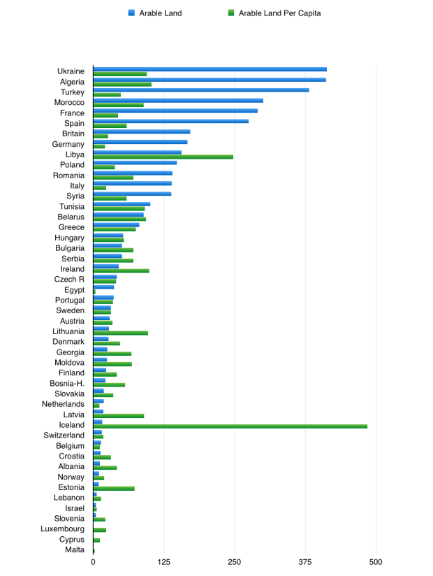
Morocco is an outlier also in terms of its economy (it is a net importer of fossil fuels, unlike most other Arab economies) and in its geographic location at the outer edge of Africa and Europe. Though Morocco has not been able to capitalize much on these traits in the past – the country’s per capita GDP is under $4000 –  there are reasons to think that it will begin to outshine most other nations in the coming years.

Here are 5 factors to keep an eye out for:

1.  Ties to the Americas

Morocco has closer connections to the Western Hemisphere than do most other countries in the Arab world, for a number of reasons. One is geography: Morocco is an Atlantic country, and most people in North and South America live within the Atlantic basin. Marrakesh is 5900 km from Manhattan, 6900 km from Miami, and 4900 km from the easternmost edge of Brazil. By comparison, Marrakesh is 5400 km from the Saudi capital Riyadh, 4900 from Baghdad, and 3700 km from Cairo.

Another is language: millions of Moroccans can speak French, Spanish, or  (increasingly) English, which along with Portuguese are the languages spoken most often in the Americas.

Another is history: Morocco was not a British colony, so it does not have the same resentment against the English-speaking world that many other countries do. Also, it was liberated by the US and Britain relatively early on in the Second World War (insert Casablanca reference here).

And another is politics: the US wants at least one stable, large, non-Wahabbist political ally in the Arab world, and as a result it is views Morocco favourably. In addition, the US and British navies continues to require passage through the narrow Strait of Gibraltar between Morocco and Spain in order to access the Mediterranean.

(Morocco and the US struck a Free Trade Agreement in 2006. Outside of Canada, Australia, South Korea, Israel, Jordan, Oman, and some countries in Latin America, Morocco is the only country to have such an agreement with the US)

As the economies of Europe, East Asia, and most of the developing world are simultaneously struggling at the moment, whereas the economy of the United States remains relatively vibrant, Morocco’s linkages to the US and other countries in the Americas could provide it with a significant advantage over its peers.

2. Oil and Food Imports 

Falling commodity prices in recent years have left most Middle Eastern countries panicking, depending as they do upon energy export to maintain their economies. Morocco too could be hurt by the falling price of energy, as it has benefited in the past from tourism, investment, and financial transfers coming from oil-rich states like Saudi Arabia. Still, Morocco is not a net commodity exporter itself. Quite the opposite, in fact: as a share of GDP Morocco is one of the world’s biggest net oil importers among countries with significant-sized populations, and it is also one of the bigger food importers.

Morocco does not even trade much with its energy-exporting neighbour Algeria, as the two have been rivals of one another because of Morocco’s ongoing control of Western Sahara. Morocco does trade, however, with Spain and with Portugal, both countries that could benefit significantly should cheap oil and gas prices persist.

(Source: The World Bank; Wall Street Journal)

3. Spain’s Economic Recovery

Spain and Portugal have been in a very deep economic recession since the “global financial crisis” hit. The southern regions of Spain, meanwhile, have been in a Depression in which as recently as 2015 they had formal unemployment rates of well over 30 percent, higher even than in Greece. This has not been good for Morocco at all, which sits just 14 km across the Straits of Gibraltar from southern Spain. The two Spanish “ex-claves” in Morocco, Cueta and Melilla (which have a combined population of 165,000), have similar unemployment rates.

Since the beginning of 2015, however, Spain is thought to have been the fastest growing significant economy in “Western Europe” apart from Sweden or Ireland, and Portugal has also been doing much better than in previous years.  Meanwhile the heart of the “Eurocrisis” seems to have moved to Italy, which could be very bad for neighbouring Tunisia and so make Morocco even more of an outlier in terms of being a stable economy within the Arab world.

(Source: Eurostat)

(Morocco exports slightly more to France than to Spain, however given that France’s GDP is more than twice as large as Spain’s, this indicates Morocco’s closer economic ties to Spain)

4. Modern Communications

Morocco is a semi-rural country. According to the World Bank, 40% of Morocco’s population live in rural areas, compared, for example, to 57% in Egypt, 33% in Tunisia, 30% in Algeria, 31% in Iraq, 27% in Iran and Turkey, and just 17% in Saudi Arabia. Morocco is also the most mountainous country in the Arab world outside of Yemen, making many of its inhabitants – in particular its rural inhabitants –  somewhat isolated from one another as well as from the outside world. Morocco’s population could benefit from Internet and mobile phone access helping it to overcome this isolation, then.

Morocco might also benefit from modern communications because of its unique linguistic abilities: its population speaks four different prominent languages, namely Arabic (which is spoken not only in Arab countries, but also by at least tens of thousands of people in almost every Muslim country), French, Spanish, and (increasingly) English. Morocco is in fact one of the few countries outside of Spain or the Western Hemisphere in which significant numbers of people are capable of speaking Spanish. Moreover, if Spain and Portugal benefit from being able to forge closer connections with Spanish and Portuguese speakers in the Americas as a result of the Internet, Morocco could benefit indirectly from their success.

The Internet could be particularly useful in helping Morocco to connect usefully with the rest of the Arab world, which until now Morocco has been somewhat cut off from as a result of its faraway location – it is a five hour flight from Morocco’s biggest city Casablanca to Cairo, and nearly an eight hour flight from Casablanca to Dubai – and as a result of its poor political relationship with its next-door neighbour Algeria. Given that most of the Arab world’s population and almost all of the Arab world’s economic activity occurs in the Middle East (including Egypt) rather than in North Africa (excluding Egypt), the distance-shrinking effects of the modern Internet could be of special assistance to Morocco.


(above: Population by country; below: The Moroccan diaspora)


5. Self-Driving Vehicles 

Morocco is located at the front door of Western Europe. It has to cross just one border to reach Spain, two borders to reach France, and three borders to reach Germany, Britain, or Italy. (By comparison, Turkey has to cross at least five borders to reach Germany or Italy by land, six to reach France, and seven to reach Britain or Spain). Still, Morocco cannot yet seamlessly access these countries.

It is, for example, 2350 km from Casablanca to Paris by land, a route which crosses the Strait of Gibraltar as well as a number of mountain ranges in Morocco, Spain, and southern France. This can make transport difficult, particularly by train. Trains cannot easily drive on and off of ships like trucks can, and they cannot handle steep inclines and sharp curves in mountainous areas as easily as trucks (particularly small trucks) can.

Indeed Morocco has only the 71st largest railway network in the world, according to the CIA World Factbook, smaller even than Tunisia’s. Spain has a much larger rail network, of course, just not once you account for Spain’s economic size. Moreover, few lines cross the Pyrenees Mountains on Spanish-French border, and Spain’s railways mostly use a different rail gauge as France’s, so the two systems to do not always link up quickly.

Smarter cars and trucks — and, eventually perhaps, self-driving cars and trucks — would be a boon for countries in the mountainous Mediterranean region, notably Morocco but also Algeria, Spain, Italy, southern France, Greece, Turkey, and the Balkans. They could make it safer and cheaper for cars and trucks to navigate difficult mountain roads. For Morocco, they could also make it easier to manage the long delay trucks typically face in crossing the Strait of Gibraltar, a body of water that is often too stormy to cross. If this happens, then the lack of national borders separating Morocco from large economies in Western Europe could become a significant economic advantage.

Over the longer-term, self-driving vehicles could also help Morocco to leverage its location as the sole land bridge between Western Europe and the huge region of Western Africa.

Economies in Western Africa often have a difficult time reaching European markets by sea. Either they are landlocked (approximately 70 million people live in landlocked countries in Western Africa, and many more are part of landlocked groups within non-landlocked countries, like the nearly 60 million Hausa or Fulani of Muslim-majority northern Nigeria), or they have to sail all the way around West Africa to reach Europe (most notably in countries like Nigeria — see map below — where most of the population of Western Africa lives), or they lack access to good natural harbours and ports (in the Nigerian megacity of Lagos, for example, “the [shipping] terminals are both practically in the city centre, so it can take an entire day for a lorry to get [through traffic] from the terminal to a warehouse“, according to the Economist), or their ships are subject to piracy.

(http://blog.crisisgroup.org/africa/nigeria/2015/12/04/nigerias-biafran-separatist-upsurge/)
The alternative to maritime shipping is to cross the Sahara Desert. That is, of course, far easier said than done: the routes across the Sahara are long, difficult, and dangerous. Still, they have a shot to become economical, given the challenges involved in the the sea route. Driverless trucks, which are both safer and cheaper than having a human driver risk crossing both the Sahara Desert and Morocco’s Atlas Mountains, could perhaps tilt the balance (in some cases, at least) between the land and sea routes. If this occured, it would reverse the process that began in the 1400s, when it first became easier to reach this region by ship than by caravan.

Finally, self-driving vehicles could perhaps make it easier for Morocco to access markets in Latin America. Most people in Latin America live in southern Brazil,  around Sao Paolo, and in neighbouring northern Argentina, around Buenos Aires. (The state of Sao Paolo alone accounts for an estimated 32% percent of Brazil’s GDP, without even taking into account neighbouring Rio de Janeiro). Yet this is a long sail from Morocco. It would instead be much quicker for ships to land somewhere around the eastern tip of Brazil and then drive overland to cities like Sao Paolo (see map below). Thus far it has been difficult to drive the more than 2000 km that this route is made up of, however, as it crosses long distances through Brazil’s eastern coastal mountains. Brazil’s traffic jams and road conditions are notoriously difficult to deal with; this route could certainly use a big boost from technology.

(Morocco controls Western Sahara)

Image of the Day – December 1, 2015 – The Turkish-Bulgarian Border

Topographic_Map_of_Bulgaria_English.png

The land border between Bulgaria and Turkey currently serves as the southeastern frontier of the European Union, and it also Turkey’s most vulnerable one. Whereas Turkey’s eastern borders are separated from the majority of its population by over a thousand kilometres of hills and mountains, the distance between Istanbul and the Turkish-Bulgarian border is less than 200 kilometres, and the terrain is relatively flat the whole way.

Not incidentally, it was from the area that is today Bulgaria that the Romans conquered Byzantium (today’s Istanbul) in 173 BC, and that European forces conquered Constantinople (also today’s Istanbul) during the Fourth Crusade in 1204 AD. In fact the Turks themselves conquered Constantinople from this direction, in 1453 AD, though in their case they approached the city from both east and west simultaneously.

If Turkey were to formally or informally dominate even just the southern half of Bulgaria, as its Ottoman predecessors did for nearly five hundred years between 1396 and 1885, the distance between its western border and Istanbul would double. Even more important, Turkey would then be able to anchor itself on the Balkan Mountains instead of on the flat lowlands which currently comprise much of the border between the two countries.

This would give Turkey a defensible buffer in the north, while also allowing it to outflank any theoretical threat that might emerge on its border with Greece, its long-time rival, which like Bulgaria has a border located near to Istanbul. In addition, it would allow Turkey to prevent the Russians from circumventing the Turkish Straits by sending their goods to the Mediterranean by way of Bulgaria and Greece. Obviously the Turks would find such a state of affairs to be quite beneficial, all other things being held equal.

This is important, because Turkey could probably dominate Bulgaria if it wanted to, unless the Bulgarians were receiving support from an outside power like the United States, Russia, or the Europeans. Turkey is a much larger and wealthier country than Bulgaria is. Its gross domestic product is thought to be 20 times larger than Bulgaria’s, and its population is more than 10 times larger than Bulgaria’s. There is, in addition, a large Turkish diaspora living within Bulgaria, accounting for more than 10 percent of the country’s total population and more than half of the population in two of its 28 provinces.

You can read the full article here.

Why Iraq is Still So Important

stock-photo-near-east-from-egypt-to-pakistan-shaded-relief-map-colored-according-to-elevation-data-source-21247816

So, why did the United States decide to invade Iraq in 2003? There may have been some sinister or stupid reasons for the war, as an overwhelming majority of Americans believe there were, but there were also strategic motivations behind it, which are almost never acknowledged. These were, namely:

1. To weaken the position of the Sunni Arabs in general, and Saudi Arabia in particular, within the Middle East. Even though Saddam Hussein’s Ba’athist, Sunni-led government was often unfriendly towards other Sunni Arab states like Saudi Arabia and even attempted to annex Sunni-majority Kuwait, Saddam’s Iraq was ultimately aligned with the Saudi Arabian position in the region anyway.

This was a result of Iraq’s intense rivalry with the Shiite non-Arab state of Iran, which it had fought an enormous war against throughout most of the 1980s, and because of Iraq’s repression of its own Shiite Arab majority population, which its had acted with brutality toward during the 1990s. The Saudis were afraid that Shiite Iran and Iraq’s Shiite majority would one day work together to undermine the Saudi position within Saudi Arabia’s own Shiite-inhabited Eastern Province, which is extremely far away from where most Saudis live and yet is also where most Saudi energy production is located.

[Saddam Hussein’s government may have been a nominally secular Ba’athist one, but that did not stop him from engaging in religiously sectarian politics during most of his time as Iraq’s leader, or from adding the phrase “God is Great” to the Iraqi flag in 1991 in what was sometimes said to be his own handwriting. With the collapse of Iraq’s secularist patron the Soviet Union around 1990, and with the increase in worldwide pan-Islamism around the same time (as a result of various factors, such as the Islamic victory in the Afghan-Soviet War in the late 1980s, the gaining of independence for Muslim countries in Central Asia as a result of the breakup of the Soviet Union, the wars between Muslim and non-Muslim populations in the 1990s in places like Chechnya, Yugoslavia, Lebanon, Palestine, Armenia, Kuwait, Kashmir, Sudan, and East Timor, and the increased globalization of Islam as a result of the emergence of the Internet), it is not clear to what extent Iraq’s Ba’athist-style secularism — such that it was — would have survived had it not been toppled by the US invasion].

The United States blamed the Sunnis, and especially the Sunni Arabs, and especially Saudi Arabia, for 9-11, and for most Islamic extremism in general. Even as the Bush administration named Shiite Iran, and not Saudi Arabia, as one of the three “Axis of Evil” countries, it also knew that Iran’s influence was limited by the fact that 90 percent or so of the world’s Muslims are Sunni rather than Shiite, and by the fact that Iran is not an Arab country. Moreover, it knew that Iran’s state-driven brand of religiosity was far less socially conservative – and far more often ignored by its own citizens – than that which exists in several of the Sunni areas of the Muslim world, in parts of Africa, Arabia, and South Asia.

Thus the United States was not too surprised to learn that fifteen of the nineteen 9-11 hijackers, in addition to Osama bin Laden and some of the other Al Qaeda leaders, were Saudi nationals. Saudi Arabia, after all, has such an extreme political and social system that its millions of women are still not even allowed to drive a car. The US also laid a portion of the blame for Pakistan’s aquisition of nuclear weapons in 1998 at the feet of Saudi Arabia.

[In fact, less than a year before 9-11 an airplane flying from Saudi Arabia to London was hijacked by four Saudis and taken to land in Iraq, which sent both the passengers and hijackers back to Saudi Arabia. A month before that, a Qatari plane was hijacked and flown to Saudi Arabia. And only six months before 9-11, a Russian plane was hijacked by Chechens and flown to Saudi Arabia, where it was stormed by Saudi special forces. Airplane hijacking has a long history in the Arab world; the Popular Front for the Liberation of Palestine in particular hijacked many planes during much of the Cold War, and was able to pass on its experiences because its hijackers were often never arrested or killed. Most notably, on September 6, 1970, the PFLP hijacked four airplanes simultaneously – three of them successfully, one, an El Al plane, unsuccessfully – and landed two of them on a Jordanian airstrip. Yet another plane was hijacked two days later and also taken to Jordan, together triggering the Black September war a week later. The hostages from the hijacked aircraft, with the exception of Jewish hostages, were freed on September 11].

The US did not feel it could invade Saudi Arabia, however, because Saudi Arabia was too large and rugged (it has the seventh largest territory in the world, and is covered mostly by deserts and mountains), too rich in oil and natural gas infrastructure (unlike Iraq, where the energy sector had been severely underdeveloped as a result of decades of sanctions and war), too conservative and internally fractious (the US fears what would become of Saudi Arabia and Yemen if the Saudi royal family were overthrown), too strategic (the US worries that, absent the Saudis, Iran would become too influential within the Shiite-majority Persian Gulf region, and also that instability in Arabia might endanger global trade routes through the Red Sea to Suez), and too sacred (the US does not want to put its soldiers anywhere near the Saudi-controlled holy cities of Mecca or Medina, particularly given the ongoing American support for Israel’s control of Jerusalem).

As such, the Bush administration saw the de-Baathification of Iraq – i.e. the disempowerment of Iraq’s Sunni Arab minority, and by extension the empowerment of Iraq’s Shiite Arab majority and Sunni Kurds –  as the next best way to weaken the regional position of the Sunnis and Sunni Arabs in general and both Iraq and Saudi Arabia in particular. Indeed, the United States had already spent the decade prior to 2003 helping to build up the strength of Iraqi Kurdistan in defiance of Saddam Hussein’s government, and wanted to ensure that this work would not be undone by the Sunnis in Iraq and neighbouring Turkey who most fear Kurdish separatism.

2. To turn the United States into the dominant power in the Middle East over the short-to-medium term, by temporarily taking control of Iraq and its massive conventional oil and gas resources (the world’s third and seventh largest, respectively, according to the US Energy Information Agency), and by using Iraq as a platform from which it could put pressure on neighbouring countries like Saudi Arabia, Iran, Syria, and Turkey. There are a number of reasons why control of Iraq seemed necessary, or at least useful, for this purpose:

– eastern Saudi Arabia, which borders Iraq, is where most Saudi oil and gas is located, yet it is a Shiite-majority region in an otherwise Sunni-majority country

– western Iran, which borders Iraq, is where much of Iran’s oil and gas is located, yet it is a majority Arab, Kurdish, Azeri, and Lur region in an otherwise Persian-majority country. (Ethnic Persians only make up an estimated 50-65 percent of Iran’s population). The Arab region of Iran, Khuzestan, is particularly energy-rich and vulnerable to Iraqi intrusion.

– eastern Syria, which borders Iraq, is where most of Syria’s oil is located, yet it is a majority Sunni Arab and Kurdish region in a country ruled by the non-Sunni government of the Assad family

– Kuwait, as the events leading up to the First Gulf War in 1990 showed, is incredibly vulnerable to external Iraqi pressure. Kuwait is the world’s eighth or ninth largest oil producer. Though it is majority Sunni country, it also has a large Shiite minority – perhaps 20-25 percent of its total population – most of whom live in the areas where most of Kuwait’s oil is extracted or exported from. In addition, Kuwait’s population of non-Arab, and often non-Muslim, foreign workers now outnumbers its own citizens by a decent amount.

– Qatar and the United Arab Emirates, both of which also share the Persian Gulf with Iraq and are also among the world’s leading oil or natural gas producers, are in a somewhat similar position to Kuwait, albeit with less direct exposure to Iraqi influence

– Jordan, which borders Iraq, has in effect a Palestinian-majority population, yet is ruled over by a royal family that was brought in from faraway Mecca by the British in the 1920s. The Jordanian royal family has survived mainly via an alliance with the US, Britain, Israel, and the Gulf Arabs. It shares a long border with Israel, from which Jerusalem is only 25 km away, and with Syria, from which Damascus is only 75 km away. Back in 2003, Jordanian politics were crucial to Israel and its allies within the United States, as Israel was then in the midst of the Second Intifada (from 2000-2005), a guerilla war which was many times more deadly to Israelis than any of the Gaza or Lebanon wars since have been

– eastern Turkey, which borders Iraq, is where most of the dams on the headwaters of the Tigris and Euphrates Rivers, from which Iraq and eastern Syria derive most of their freshwater, are located. It is also where the Turks hope to build energy pipelines linking both the Middle East and Central Asia to Istanbul and Europe. It is, however, a majority Kurdish region, in an otherwise Turkish-majority country. Kurds in Turkey account for an estimated 20 percent of Turkey’s overall population, and for more than half of the overall Kurdish population that spans Tukrey, Iraq, Iran, and to a lesser extent Syria.

– eastern Turkey also borders Azerbaijan and the Christian countries of Armenia and Georgia. Armenia is an enemy of Turkey and ally of both Russia and the US, while Georgia is an enemy of Russia and an ally of the US. Azerbaijan, which fought a terrible war against Armenia during the 1990s, is a significant state in its own right: it is the world’s 20th largest oil producer, borders Russia’s separatist-inclined Muslim territories like Chechnya and Dagestan, and, most importantly, borders the Azeri-majority regions of Iran. Azeris account for perhaps as much as 25 percent of Iran’s entire population; indeed, Azerbaijan has even toyed with the idea of renaming itself “Northern Azerbaijan”, implying that Iran is in direct occupation of “Southern Azerbaijan”. Iran’s Azeris are linguistically about the same as those in Azerbaijan, and not too different from Turks in Turkey.

[Azerbaijan is also the world’s only formally secular Shiite state, which means that the religious Shiite Iranian regime, which rules an Iranian population that includes an increasingly large number of modern-minded Shiites as well as many Sunni, Sufi, and secular Muslims, views the Azeris as a major social and ideological threat as well. Thus Azerbaijan, which is less than 300 km from Iraq, is strategically important in spite of having a population of just around 10 million. Azerbaijan is, finally, the only link for future Turkish-European pipelines to cross the Caspian Sea to Turkmenistan, which has been thought to hold the world’s fourth largest accessible reserves of natural gas.]

Iraq, in other words, is not just immensely energy-rich: it is also far and away the most strategically vital country in the Middle East, capable of pressuring all of the countries it borders – Turkey, Iran, Saudi Arabia, Syria, Kuwait, Jordan, and beyond – when it is internally unified or under the domination of a foreign power.

The United States hoped to exploit both of these traits in order to throw its weight around within the region and attempt to prevent a second major terrorist attack from occurring on American soil. This is, similarly, why Iraq continues to draw global attention today. The recent US decision to cut a deal with Iran was in made in part because of the gains that ISIS – representing some of the Sunni Arabs – and the Sunni Kurds have made within Iraq.

None of this necessarily changes the fact that the Iraq War was arguably a strategic mistake for the United States, and possibly a moral failure as well. Still, it may be comforting to know that, contrary to popular belief, the reasons behind the invasion were not entirely incoherent or sinister (or at least, not incoherent or sinister in the ways that people have generally assumed they were). And perhaps we should not judge Bush too harshly for concealing his true purposes. After all, Obama cloaked his support for Syria’s rebels in precisely the same anti-tyranny, anti-WMD rhetoric that Bush once employed towards Iraq, consistently avoiding the fact that the rebels’ success benefited the United States by curtailing Iranian influence in places like Syria, Iraq, Lebanon, Jordan, and Palestine.

And now that Assad has weakened, Obama finds himself again with the same dilemma as Bush, wanting to move closer to the Shiites and/or Persians in the region in order to counterbalance the dominant Sunnis and/or Arabs, yet also concerned that this will result in increased Sunni militancy, a destabilized Arabia, and an ascendant Turkey or Iran.

Of course, this is not what the (Jeb) Bush’s or (Hilary) Clintons say. With those two running for office, we could be in for yet another round of Iraq War misdirection. May the best candidate win.

Image of the Day — November 26, 2015 — Clash of “Civilizations”

Clash of %22Civilizations%22

(Eastern Christian Orthodox countries include Russia, Ukraine, Romania, Bulgaria, Greece, Serbia, etc.; Turkic Muslim countries are Turkey, Kazakstan, Uzbekistan, Turkmenistan, Azerbaijan, Kyrgyzstan, and Northern Cyprus. For Turkey, the two most important Christian Orthodox countries are Russia and Greece.           …take these numbers with a grain of salt though, it’s hard to be sure of these things, particularly when going back a few decades and looking at large closed-off economies like the former Soviet Union)