With autonomous driving, cargo could be transported by very small vehicles. Very small vehicles could use very small tunnels. Given the expense of tunnelling, very small tunnels could be much cheaper to build than larger tunnels. This could be useful in urban areas, to avoid road traffic, allow cargo to be transported late at night without creating too much noise, and use an electrified system (rail, cable, or trolley) rather than use relatively heavy and bulky batteries or internal combustion engines. It could also allow autonomous vehicles to avoid (or reduce) sharing the road with human-driven vehicles, and could allow for autonomous driving without requiring expensive systems like Lidar and without having to deal with technical challenges like snow.
Such tunnels would also facilitate the use of shortcuts, whether within cities (e.g. to pass under a highway or river valley) or to cross natural barriers in order to reach cities. This would be especially useful if the price of oil (and/or the price of energy in general) were to increase. Cargo often takes a lot of energy to transport, but by using shortcuts you reduce the total travel distance required. Plus, by transporting more goods at night, you can benefit from power prices often being much cheaper at night.
If these tunnels are going to be built, the next obvious question becomes “could humans travel in them too?” This question has already become popular, of course, with Elon Musk’s “hyperloop” concept and Boring Company being the most obvious example.
Obviously, though, there are challenges to transporting humans when compared to cargo. First, there are safety concerns. Second, there is comfort: plans like Hyperloop assume that people don’t want to travel around lying on their backs, which means that tunnels to transport people would have to be bigger (and thus more expensive) than those used to transport cargo. Third, there is speed. Plans like Hyperloop assume that humans want to get from one place to another quickly. But with increased speed comes increased safety and comfort concerns and, given that the safe/comfortable distance between vehicles tends to increase at a rate that is the square of the vehicles’ speed (so, going twice as fast can result in moving half as many people). Speed also tends to reduce fuel-efficiency, given air resistance and surface friction. Finally, speed tends to reduce accessibility: since more accelerating and decelerating is needed with more speed, the number of entrance and exit points to the tunnel may decrease. (Roads, for example, have many more access points than highways).
But what if we do away with the assumptions that human travellers need speed, and that human travellers are unwilling to lie on their backs within a narrow tunnel? What if, like Dracula in hibernacula, people could sleep while travelling at very slow, steady speeds in a comfy capsule capable of using narrow tunnels? If by travelling slowly the vehicle could avoid decelerating and accelerating, then the human within it would not (in theory) even be able to know that he or she was moving, and so might be able to get a very good night’s sleep. At a speed of 100 km per hour, the passenger could travel 800 km in 8 hours, to cross a natural barrier via a traffic-free, shortcut route, then wake up the next morning at their urban destination. During the day, assuming that passengers would not want to spend more than an hour or two lying down in a capsule, the system could then transport more cargo long distances, and people shorter distances, crossing under natural barriers while taking a power nap.
Fighting for bike lanes, pedestrian spaces, HOV/bus lanes, and right-of-way streetcar lanes is difficult in Toronto. Much of Toronto’s population is suburban, and much of Toronto’s tax revenues are controlled by an Ontario government that is partially influenced by Ontario’s largest industry, car manufacturing.
Still, most of this fight has focused only on how to share road space. In my opinion, what we should be pursuing instead is a plan to share road-use time, in order to reflect the fact that the needs of Toronto — especially as it relates to bike lanes — are very different in summer than in winter. The political compromise we should be pursuing should be to make Toronto a great city for transit, cycling, and pedestrians during the warmer, brighter half of the year, while allowing cars to continue to be the dominant form of transportation during the colder, darker half of the year.
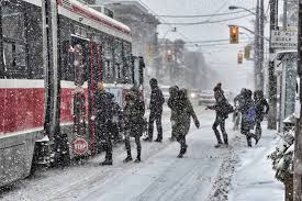
In the winter, most people do not want to bike, fewer people want to walk to transit stops or wait at outdoor transit stops, and more people want to have street parking so they do not have to walk far to get to and from their parked cars. This will only become true as Baby Boomers get older, as the risk of their slipping and falling on ice becomes more significant. In summer, on the other hand, more people want to bike, people do not mind walking further to and from their parking spot as much, and people do not mind walking to or waiting at a transit stop as much either.
In summer there are also more tourists in the city, who want to use transit (or taxis), and walk or bike. Summer tourism is likely to increase in the future as technology makes it easier for people to travel more, given that many other cities in North America (and the world) are unbearably hot in summer, and given Toronto’s proximity to the lakeside cottages and camping sites of the Canadian Shield.
There are also smog issues during the summer, which could be reduced by using cars less often.
But, you might ask, if we give over most of our road space to transit, cycling, and pedestrians during the good-weather half of the year, what will we do with all of our cars? And woudn’t we have way too few busses and streetcars to facilitate this huge seasonal increase in transit ridership? (And if we buy more busses and streetcars in order to solve this problem, wouldn’t they then be underused during the car-dominated colder half of the year?)
The solution to this problem may, at least in part, be a seasonal form of car-sharing. Torontonians could have the option to make a profit by doing one of the following things:
—not own a car
—renting their car to an Uber driver (or a service like Uber) during the warmer half of the year, so that it could be used as an UberPool vehicle in an HOV lane shared with ttc busses
— renting their car to Car2Go (or a service like Car2Go) during the warmer half of the year, in order to help people travel the first-mile/last mile to and from transit stations
—using their car in cottage country. Or, renting their car to a service like Car2Go in cottage country, so that people could take the train or bus to get to and from cottage country, so that we reduce the economically and environmentally damaging practice of clogging up the highways to Muskoka with cars every weekend
—rent the cars to towns in Northern Canada during the warmer half of the year, since the seasonal changes that Toronto experiences are nothing compared to those Northern Canada does
— maybe, partner with US Sunbelt cities. If they do a reverse version of the seasonal system we do (in other words, if they become transit, cycling, and pedestrian friendly in the winter, when they have great weather, but then go back to being car-friendly in the summer when their weather is way too hot) then Torontonians could perhaps save money by sharing a car with a Southerner, with the Torontonian using the car in winter and the Southerner using the car in summer
Of course, most people won’t rent out their car like this for half the year. But as long as some do, it should be sufficient, given how much more utility can be gotten out of a single car when used as an Uber/UberPool/Car2Go type of vehicle, as compared to when used as a conventional car that mainly sits idle all day and night.
So, instead of fighting for transit-only/cycling/pedestrian/carpool lanes, we should advocate for transit/cycling/pedestrian/carpool seasons.
Light rail systems are often a Goldilocks-style compromise between the flexibility of automobiles and the efficiency of trains. The problem is, nobody likes Goldilocks.
If, for instance, Doug Ford is elected premier of Ontario this spring, it is not unlikely that he will cancel the Hamilton, Hurontario, and Sheppard LRTs, leaving only the Eglinton Crosstown and Finch West projects that are already underway. And Toronto’s mayor and city council already voted last year in favour of the suburban Scarborough Subway Extension, over an alternative plan to build that line as an LRT and then use the money saved to help fund an Eglinton East LRT.
On the autonomous vehicles front, meanwhile, a number of significant barriers to entry remain. These include: LIDAR (still very expensive, and still struggles with snow); LIABILITY; the fact that people already own conventional cars; the fact that autonomous cars (even electric ones) still cause traffic and environmental harm; and the risk of autonomous vehicles being used in a terrorist attack (for e.g. if driverless cars are common, a single bombmaker might be able to load numerous vehicles with explosives, and detonate all of them simultaneously at a crowded urban location). And of course there may also be a societal hesistancy to adopt widespread driverless cars.
Because of these barriers, it seems plausible that the partial use of autonomous vehicles will occur before they become fully adopted. Consider, for example, two potential partial usages: autonomous parking lots, and autonomous overnight cargo deliveries. Both of these may not be subject to the barriers listed above:
—LIDAR may not be a challenge for autonomous parking lots, as within a relatively small, mapped area equipped with sensors (the parking lot), cars could drive autonomously without LIDAR. Overnight delivery vehicles might also be able to run without LIDAR, as they could drive at a very slow speed, and stick to running a relatively small number of high-demand routes
—Liability may not be a challenge either, as the parking lot could have no pedestrians or human drivers in it, and its cars could drive at slow speeds. Overnight delivery vehicles could also drive at slow speeds.
—the fact that people already own conventional cars is not a barrier to overnight cargo deliveries, and may not be a barrier to parking lots either. Some companies are even attempting to develop vehicles that can, in effect, tow a conventional car autonomously to and from parking spots
—the fact that autonomous cars still cause traffic and environmental harm may not be a barrier: autonomous parking lots can reduce traffic and pollution if they are located at (for example) train stations, thereby making it more convenient for suburbanites to use transit. And overnight deliveries might cause fewer diesel trucks getting stuck in daytime traffic jams, which create air pollution and other costs
—restricting autonomous vehicles mainly to limited areas like special parking lots, or special times like very late at night, could make it much more difficult for them to be used in a major terror attack (whether a car-bomb/truck-bomb attack or driving a vehicle into pedestrians, involving multiple vehicles simultaneously) as it would then remain suspicious for a driverless truck to be loitering in a crowded urban area
—special autonomous parking lots, and perhaps also overnight autonomous cargo deliveries, are much less likely to be subject to a societal hesitancy towards their adoption
LRTs in particular may benefit from autonomous parking lots and/or autonomous overnight delivery vehicles. Autonomous parking lots may promote transit usage in general, if the parking lots were located at transit stations. But perhaps LRT would benefit from them more than heavy rail would, as the flexibility of LRT relative to heavy rail could allow LRTs to directly access more of these parking lots.
For overnight cargo deliveries, LRTs could be the ideal vehicle to be used autonomously. LRTs are electric and therefore relatively quiet, and being quiet is crucial for overnight usage in cities. Also, electricity prices are cheaper at night than they are in the day (particularly in Ontario, given that the province’s nuclear and wind power cannot shut off at night). And, of course, they are much cleaner than non-electric (or even electric) trucks. In addition, an LRT, unlike heavy rail, could more often travel directly into a building or parking lot to load/unload its cargo.
One main problem that has prevented cargo light rail in the past (outside of a few exceptions, for example in Dresden where a cargo tram has run) has been that trains have less surface friction than wheeled vehicles, so it is difficult for an LRT carrying a heavy amount of cargo to accelerate and decelerate constantly in cities in order to stop for red lights, passenger stops, and — if the LRT is not operating in its own separated lane — cars. At night, however, there are far fewer cars or passenger LRT stops, and green light-red light cycles could be made to run for far longer lengths of time in order to minimize the number of times an LRT has to stop.
With autonomous vehicles, then, LRTs may no longer be only a compromise between heavy rail and autonomobiles, but instead might excel at complementing autonomous parking lots, or being used autonomously to deliver cargo.
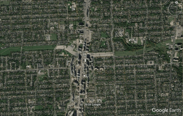
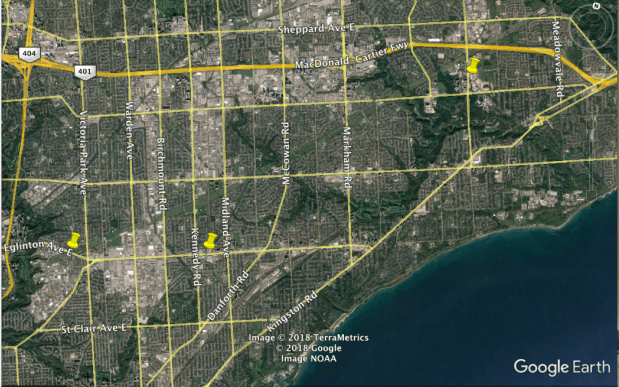
What does this mean for Toronto? Well, as mentioned earlier, it is possible that all but the Eglinton Crosstown and Finch West LRT plans may be cancelled as a result of the coming election. The Eglinton and Finch LRTs, as it turns out, have something in common that could be relevant to this discussion: they are next to the city’s two major hydro corridors, the Finch Corridor and the Gatineau Corridor. These corridors could be used as autonomous parking lot systems that are directly accessible to passengers using the LRTs, as well as accessible to passengers using other corridor-adjacent transit stations like Finch Station and Kennedy Station. They would also be accessible to cyclists using the bicycle paths that already exists within these two hydro corridors.
If you look at Finch subway station (map above, picture below), you will see that it already has a large parking lot, 1.3 km long and 90 metres wide, within the Finch hydro corridor to both its west and its east. I propose that this lot be extended much longer, to reach north of the Finch West LRT, as an autonomated parking lot corridor. This corridor would mostly remain separate from road traffic and pedestrians, though not entirely separate: it would have to cross north-south streets, and would also have to use bridges on Finch in order to cross topographical barriers like G Ross Lord Park. But that would still be much less of a challenge than a widespread adoption of autonomous vehicles. The Finch corridor is about 210 metres north of Finch in most places, and in some places (such as west of Jane, or west of Bathurst, or between Dufferin and Keele) it widens to connect to Finch Avenue directly.
Finch Subway Station (Yonge and Finch)
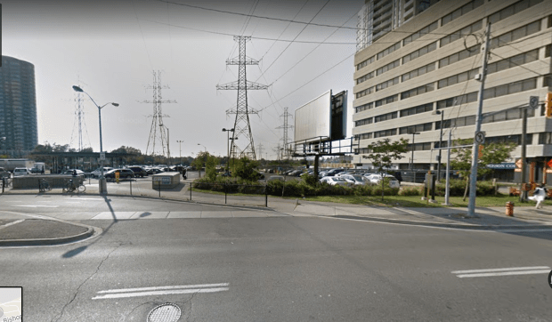
The Gatineau Corridor, meanwhile, intersects with the Eglinton Crosstown just west of Victoria Park, and also (via the narrower Scarborough RT corridor; see bottom image below) at the Crosstown’s terminus station, Kennedy Station (which is also a station on the Bloor-Danforth subway, Scarborough RT, and Stoufville GO train). If the Eginton East LRT extension to the Crosstown is built, its terminus would also be by the Gatineau corridor, at U of T Scarborough campus.
Above: 3 Locations Where Gatineau Corridor Meets Eglinton (or Eglinton East) LRT; Below: Kennedy Station
The corridor could be relatively quiet, since the cars parking in it could travel slowly. It would not be an eyesore; or at least, not more of an eyesore than the hydro towers are themselves. It would also, ideally, be “parking lot neutral”; in other words, by creating more parking on the hydro corridor, it would allow you to convert some existing parking lots elsewhere into buildings/parks/etc. It would promote an increase in transit ridership. And the corridor could also be used, seasonally, as a “bicycling highway” that would be usefully located next to the autonomous parking lot. This could be acheived by simply having a portion of the hydro corridor’s lanes be designated for cycling instead of parking during the warmer months of the year. This could be a transit option that both the suburban, car-driving Ford Nation and the latte-drinking downtown bicycle-lovers could enjoy.
The Phoenix Suns had the worst record in the NBA this season. They won only 1 out of every 4 games they played. While they are young enough to get better next season, and have a great young shooting guard in Devin Booker, they are also likely to be playing in a league where most of the best teams become much better this offseason. This year many of the best players were either stuck on really bad teams (Lebron), or had injury problems (the Celtics, Warriors, Spurs, 76ers, Timberwolves, Thunder, and others). With Lebron and other good players about to enter free agency, who knows how many superteams there will be next year?
Here’s the question, then: Is it possible to employ a strategy that could turn a bottom-ranked team like Phoenix into an instant contender?
In amateur basketball leagues, bad teams sometimes try an “it takes a village” type of strategy to compete with good teams. They do things like play at a really fast tempo on offense and press aggressively on defence, the idea being to tire out the opposing team’s star players so that the game ends up being decided by a more balanced competition between the two teams’ bench players. The problem is, in the NBA this strategy would not work. Elite NBA teams often excel at playing at a high tempo, so by the time their starters get tired they will have already run up the score a too much for your team to mount a comeback against their bench players.
What I would suggest trying is a very different type of high-tempo strategy: a “specialization and trade” strategy.
In this strategy, a team like the Suns would do three things:
1) Use three different types of units during the course of the game: an offensive specialist unit, a defensive specialist unit, and a general purposes unit. (NBA teams can only use 13 players a game, so at least two players would have to play on more than one of these units. A player like Booker, for example, would play on the offensive specialist unit and on the general purposes unit)
2) Substitute your players as much as you possibly can, in order to maximize the number of offensive possessions the offensive specialist unit has, maximize the number of defensive situations the defensive specialist unit faces, minimize the number of defensive situations the offensive unit faces, and minimize the number of offensive possessions the defensive specialist unit has.
3) Play a style of basketball that would maximize the number of opportunities to substitute players you get. Such a style would be very high-tempo, and might even involve your team contesting many of the inbound passes the opposing team makes, in order to try to maximize things like the ball going out of bounds, jump balls, and non-shooting fouls. Basically, whenever your offensive specialist unit gets caught having to play defense, they will play very aggressively, trying to go for steals, deflections, jump balls, and taking charges. If they succeed in getting these things, great, if they don’t succeed, that’s okay too: they will then get called for a non-shooting foul, and therefore be able to substitute for the defensive specialist unit. A high tempo offence will also benefit the defensive specialist unit: by playing fast on offense, the defensive unit will be more likely to score than it otherwise would, since defensive specialist players are generally bad at scoring against a set defence. And the high tempo will serve the team as a whole, by tiring out the opposing team’s starters. Once the team enters the penalty situation, and also runs out of time-outs it can use to substitute players, then the general purposes unit comes on to play (at a more normal tempo) for the remainder of the quarter.
Most NBA teams already use an offense-defense strategy in the final minutes of the game. They should think about using it the entire game.
A team like the Suns is not going to beat a team like the Warriors, or player like Lebron, if it sticks to playing basketball. But if it were to play hockey, then maybe it would have a chance. In hockey, hundreds of player substitutions are made every game. In basketball, in most cases, only about two dozen subs per game are made. To compete with superteams like the Warriors, a team could strive to get closer to the hockey subs number. If the team could improve their score by even a small fraction of a point for every substitution they make, they might be able to go from a terrible team to a great one. The Suns, on average, were outscored by only 9.4 points per game this season (by far the most in the NBA); the league-leading Houston Rockets outscored teams by only 8.3 points per game.
This strategy would be especially useful in overtime: whereas in the 48 minutes of regulation time a team gets six timeouts and 4 pre-penalty fouls per quarter, during a 5-minute overtime the team gets two timeouts and 4 pre-penalty fouls. This creates more opportunities to make cost-free substitutions.
This strategy could even be used by good teams that are otherwise unable to compete with superteams. What if, for example, this strategy were to be used by the Thunder in the playoffs? The Thunder already have a player who is almost unrivalled at playing high-tempo basketball – Westbrook – and another player who is one of the elite defensive specialists in the league (but a terrible offensive player): Roberson. If the Thunder used their offseason to add offensive and defensive specialists, they could run this strategy to attempt to beat Durant and the Warriors next year, with Westbrook playing on his team’s offensive specialist unit, defensive specialist unit (every defensive specialist unit will need at least one player who isn’t bad at offence), and general purposes unit.
Necessity may be the mother of invention, but she is no sole provider. The US military has long been Necessity’s devoted husband. As the happy couple is now reaching its eighteenth anniversary since settling down for a life together in Afghanistan, it may be that the children of this extended sabbatical – namely, autonomous vehicles – will soon finally move out into the world on their own terms. Quite possibly, they will rebel against their loving parents.
The main characteristic of autonomous vehicles is the ability to travel where human drivers cannot comfortably, safely, or cheaply go themselves. Some examples include small autonomous trucks operating in mountainous areas, large autonomous trucks crossing deserts, autonomous boats accessing islands where no good ports exist, and aircraft using JPADS (Joint Precision Airdrop System) invented in Afghanistan in recent years to deliver cargo to areas that would otherwise be inaccessible as a result of natural disasters, natural barriers, or war.
These inventions may have two huge effects. First, they may help to overthrow the tyranny of Necessity, easing the transportation of basic necessities in poor countries in a way similar to what mobile phones have been doing for communication. Second, they may undermine the dominant position of the US, by empowering large, strategically located countries that have until now been limited by those very same barriers autonomous vehicles may help to overcome.
Five world regions stand out here, as areas where autonomous vehicles could be especially impactful.
One is the Latin world, particularly the Spanish world, which is characterized by mountains, rainforests, deserts, and narrow seas like the Mediterranean, Caribbean, and Atlantic. Another is the Arctic, with its air, land, and icy sea routes linking Asia, America, and Europe, encompassing large expanses of remote, resource-rich territory. A third region is Southeast Asia, with its islands and peninsulas from Taiwan to Australia, and jungles, Himalayas, and sky-high plateaus between India and China. Fourth, the vast, vibranium-rich heartlands of Africa: from the ten Great Lake countries (including Ethiopia) in the south and east, to the ten Saharan countries in the north and west.
But perhaps most important is the “Greater Middle East”: the Islamic world from Central Asia to Central Africa, spanning deserts, seas, and mountains, and sitting atop a sea of oil that will probably continue to be necessary to power any autonomous vehicles – or, at least, power any autonomous aircraft. Particularly well-situated may be the oil-rich Gulf states, such as Iraq, and the mountainous Central Asian ones, such as Afghanistan. This would be an interesting turn – one the one hand, it might actually help fulfil America’s dream of bringing democracy to the Middle East; on the other hand, it might help fulfil America’s nightmare of Islam re-emerging as a global political force.
This would be nothing new, however. Mobile phones were invented during the Vietnam War era, yet they have since empowered Communist China more than any other major state (if also, arguably, helping to de-radicalize China). Britain invented railroads during the years between its wars with the US, only to see the US empowered by railroads more than any other major power, and inherit Britain’s leading status. (Railroads also helped to de-radicalize the US: by linking America’s Northeast and Midwest they undermined the South, which had previously enjoyed influence in the Midwest by way of sailing up the Mississippi). Just as Necessity is not a single mother, Invention is no only child. Rather it has two siblings, born just moments after humanity’s first and greatest tool was invented, when its inventor accidentally burnt himself celebrating. Invention’s siblings are Illumination, and Irony.
Conventional analysis of Korea seems to be incorrect in its view of the probability of North-South reunification. The conventional view is that reunification grows more unlikely as the disparity in wealth between the North and South (now far greater than that between West and East Germany in the 1980s) continues to increase, and as young South Koreans, who tend to be more opposed to reunifying with the North, come of age.
While we have no way of knowing what the odds of reunification are, we should recognize that the logic behind these conventional views is not sound. Most South Koreans are Baby Boomers or senior citizens, so the issue of young Koreans tending to oppose the idea of reunification may not be nearly as relevant as one might think, even if we do accept the premise that public opinion will help determine the relationship between the two Koreas. An estimated 58 percent of South Koreans in general favour reunification.
As for the enormous economic disparity between the North and the South, it might actually make reconciliation between the two Koreas more probable, not less probable. This is because it makes opportunities available from economic arbitrage higher for both sides.
Unlike in previous decades, North Korea and South Korea today have complimentary economic resources and needs. South Korea’s primary resource is capital, which the North needs if it is to finally escape extreme poverty. The South’s primary need is to bolster its increasingly expensive and rapidly aging population (see Figure 1, below), as well as safeguard the imports of fuel and exports of manufactured goods upon which South Korea depends more heavily than does any other major economy (see Figure 2).
The North’s resources are its cheap labour, coal reserves, and land bridge linking South Korea to China and to Russia.
Working together, either through a reopening of trade and investment channels or through eventual reunification, the South could provide capital while the North provides labour, energy, and direct access to the labour and energy of Northeast China and Pacific Russia. Given the vulnerability of South Korea’s existing trade routes to Europe and the Middle East, which pass the Straits of Hormuz, Malacca, Taiwan, Bab-el Mandeb, and Suez, none of which South Korea has any control over, it is not difficult to see why trading with the North might appeal to the South.
In this context, the current Olympics reconciliation between the two Koreas should not have taken so many people by surprise. (The Olympics reconciliation also should not have been such a surprise because it was preceded by South Korean officials announcing, in March 2017, their intention for South Korea to present a joint bid to co-host the football World Cup in 2030 with North Korea, China, and Japan). This is not to say that theOlympics indicate that a real push towards reconciliation will now occur, let alone a push for reunification. Still, these outcomes should not be ruled out, just as the thaw in the relationship that has taken place at the Olympics should not have been ruled out.
Let us take a brief look, finally, at the current politics/economics of the four outside powers that surround and influence the Koreas: China, Japan, the United States, and Russia.
China and Japan both have leaders who have recently gained in prominence: Xi since the Party Congress this past October, Abe since the Japanese election this past October. China and Japan are both scrambling for access to energy: China to replace coal in order to reduce pollution, Japan to replace nuclear power in order to avoid another Fukushima incident. Both countries are also scrambling for labour: Japan because of its elderly population, China because of wage inflation, the impact of the one-child policy, and the aging of Chinese Baby Boomers. South Korea, which is also increasingly in need of energy and labour, will find it difficult to compete with these two giants. The only place where South Korea may have an edge over China and Japan is its fellow Korean state, North Korea.
This competition among the Northeast Asian economies might increase even more if the United States follows through on President Trump’s pledges to reduce the US trade deficit, get tough on China, and prevent allied nations like South Korea, Japan, and Germany from “free-riding” on the global sea-lanes protection that has been provided by the United States navy. Meanwhile, with the number of US soldiers in Afghanistan having been reduced from around 100,000 in 2011 to only around 11,000 today, the US may now have the ability to threaten the North Koreans more than at any time since September 11, 2001.
Russia, in contrast, is now focused on its engagements in both Syria and Ukraine, which may limit its ability to aid its historic ally North Korea. Russia’s economy is limited too, as a result of the low oil, gas, and coal prices that began in 2015. Russia depends on exporting energy to Europe, but if those exports are imperilled, whether because of worsening relations between Russia and Europe or because of the US’s new transatlantic exports of oil and liquified natural gas, Russia may have to diversify its trade patterns by exporting to East Asia. The Russians are, however, afraid of both China and Japan, and so prefer to trade with the Koreas instead. It is therefore increasingly in Russia’s interest to see reconciliation between the Koreas, so that Russian exports can reach the South via the North and so that the Koreas’ economies and demand for Russian resources can grow.
In closing, we should perhaps begin to consider the Korean situation in the same way that an experienced investor views financial markets: aware of the significance of arbitrage, and aware of the maxim that past results are not a proper indication of future returns. In other words, we should not assume that the North’s isolation and totalitarianism will necessarily continue, and we should not think that the Koreas’ diverging paths means they are less likely to re-converge going forward. Of course we should not be naive about the character of the North’s regime, and we should not be overconfident in assuming it will change. But neither should we discount the possibility of reunification, whether achieved through diplomacy, assassination, or war. Not even in 2018.
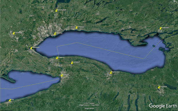
The horseshoe-shaped region that includes Toronto and Buffalo is one of North America’s most populous, with more than 10 million inhabitants.The Horseshoe’s northern half extends roughly 100 km from Oshawa in the east to Burlington in the west, and 50 km from downtown Toronto north to Newmarket. The Horseshoe’s southern half is also close to 100 km in length, from Hamilton in the west to Lockport in the east. It is 50 km from the St Catharines-Niagara area south to Buffalo.
In order for us to analyze real estate in this region, we first need to discuss three basic differences between the Horsehoe’s northern and southern halves: political, geographical, and historical differences.
Political
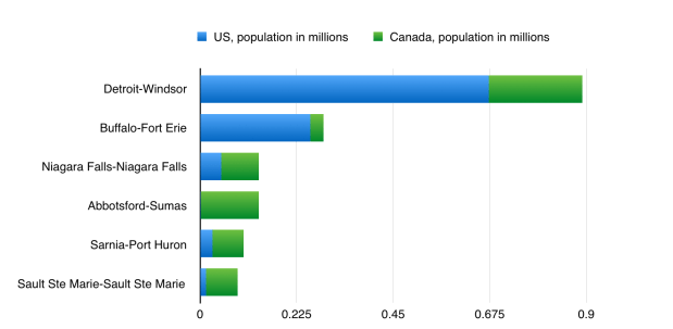
The political distinction is the most obvious of these. Whereas the northern half is entirely within Canada, the southern half is split between a Canadian side and an American side. The Canadian side of the southern half is home to roughly 1 million people, of whom 550,000 live in Hamilton. The American side is home to 1.2 million people, most of whom live in the suburbs of Buffalo. The international border runs directly through the Niagara-Buffalo urban area, making it by far the most populous urban area shared by the two countries with the exception of Detroit-Windsor:
US-Canada Border Cities
Geographical
There is also a geographic difference between the Horseshoe’s northern and southern halves. Namely, it is that the Horseshoe’s southern cities are characterized by their relationship to water and to wind:
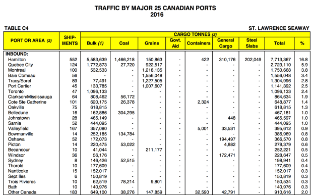
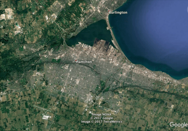
Hamilton’s significance comes historically from the city’s harbour, which is by far the largest in the western half of Lake Ontario. The harbour facilitated shipments of bulk goods, helping Hamilton to become Canada’s Steeltown. It continues to host Canada’s largest Great Lakes port.
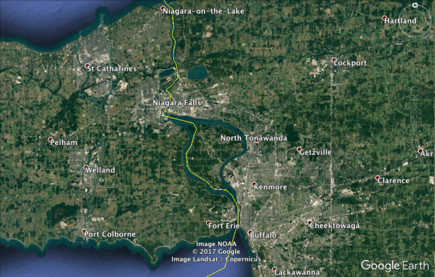
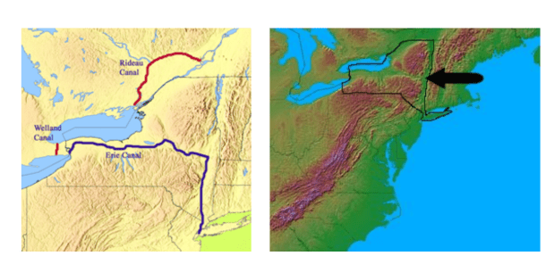
The St Catharines-Niagara urban region, which is the 12th most populous in Canada, derives its significance from two water features. One is Niagara Falls, which draws both tourists and hydropower. The other is the Welland Canal, which connects Lake Ontario to the other Great Lakes via a series of locks, bypassing the Falls. Niagara Falls was the site of the world’s first major hydroelectric station, built in 1895. It continues to generate more power than any single dam in the United States. The Welland Canal was first built in the 1820’s, and is a key link in the St Lawrence Seaway shipping route that was opened in the mid-twentieth century.
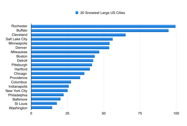
Snow in upstate New York comes mainly from winter winds blowing atop the relatively warm water of the Great Lakes. Because of these wind patterns, Buffalo actually receives twice as much snow per year on average than does Toronto. Indeed Buffalo gets more snow than any of Canada’s 18 most populous cities (a lot more snow, in most cases), with the exception of Quebec City.
Buffalo and Rochester are located in the middle of a “snowbelt”, which extends from Cleveland’s eastern suburbs all the way to the Adirondack Mountains east of Lake Ontario. The only other snowbelt cities with more than 100,000 inhabitants are Sudbury, Barrie, Syracuse, and Grand Rapids.
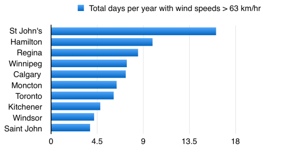
While Hamilton lies outside of any snowbelts (it gets the same amount of snow as Toronto, on average), it too is impacted by wind, being hit by among the most windstorms of any Canadian city:
Historical
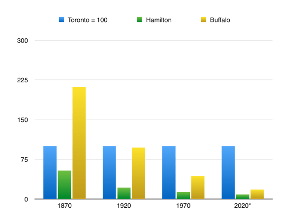
Today, the Greater Toronto Area has an estimated 6.4 million inhabitants. The southern side of the Horseshoe (Hamilton + the Niagara Region + the Greater Buffalo Area) has just half that, 3.2 million.
A little over a century ago these positions were reversed. Back in the late nineteenth century Buffalo’s population was more than twice as large as Toronto’s. In 1900 Buffalo was the eighth largest city in the US, and the fourth largest without an ocean port. Even Hamilton was not much smaller than Toronto in those days:
Relative population sizes; Toronto = 100
There are a number of reasons for this historic reversal, but they all have to do with the price of energy:
Oil
Automobiles
Air Conditioning
Cheap oil in the twentieth and late nineteenth centuries, and the technological advances of automobiles and air conditioning that cheap energy helped to make feasible, resulted in the decline of Buffalo and Hamilton relative to Toronto.
-Home air conditioning began to become widespread in the middle of the twentieth century. Not surprisingly, it led many Americans to move from cities like Buffalo to the Sunbelt. An estimated 28 percent of Americans lived in the Sunbelt in 1950; 40 percent did in 2000.
-For Sunbelt cities in the arid American Southwest, cheap energy was also necessary to ensure freshwater supplies, given the energy-water nexus. And for cities in the western half of the United States in general, cheap energy was needed to facilitate long-distance intercity transportation.
-Cheap oil also allowed land transportation — trains and automobiles — to supplant water transportation. Water transportation is far more energy-efficient than any other type of transportation, but it is also slow and inconvenient. With land transportation becoming dominant during the twentieth century, the importance of cities which were based around water transportation declined. Buffalo and Hamilton were two such cities.
-Buffalo and Hamilton were also not ideally suited to land transportation. For the Niagara peninsula, Lake Ontario and Lake Erie serve as transportation barriers for cars, trucks, and trains; so too does the Niagara Escarpment, which divides the peninsula (and Hamilton) into upper and lower segments. For Buffalo, lake-effect snow also frequently serves as a severe transportation barrier.
Toronto, in contrast, has been able to use automobiles and low energy prices to expand approximately 50 km deep into its GTA suburbs to the east, west, and north. Because it is a Canadian city, Toronto has also not had to worry as much about people moving south to the Sunbelt, as Buffalo has.
Speculating About The Future
Since we do not know what future energy prices will be, prudence suggests that we should prepare for the worst: high prices. Indeed, it seems far from implausible that high prices will become a reality, whether because of carbon pricing or because of a diminishing supply of “conventional” oil. Even in spite of the current shale oil boom in the US, few people have predicted a repeat of the low prices of the 1990s or the 1880-1970 era.
If energy prices do become high, the Golden Horseshoe may look more like it did in the late nineteenth century. Just like how cheap energy allowed the Greater Toronto Area to grow relative to Buffalo and Hamilton, so might expensive energy allow Buffalo and Hamilton to grow relative to the GTA. Similarly, what growth the GTA does experience in an energy-expensive world would be likelier to occur mainly within the City of Toronto, rather than in the GTA’s sprawling suburbs as has occured in recent decades.
At the same time, we can also expect technology to have an effect on the region. In the last century new technologies like automobiles and air conditioners had the largest impact. But how will today’s new technologies – digital technologies – impact the Golden Horseshoe?
One impact of digital technology is likely to be that computers and machines will allow more work to be outsourced or automated. As such, people’s leisure time will increase faster than will their disposable income. From a transportation perspective, this will probably benefit water transportation, which is the cheapest but also the slowest form of transportation. Only someone with a limited budget and a lot of free time would find travelling by water useful; especially if they are trying to avoid carbon emissions.
In particular, water-based shortcuts could become popular. It is just 47 km from St Catharines to downtown Toronto by water, but 113 km by road. Given that ferries are already more energy-efficient than automobiles or even trains on a km-by-km basis, having such a significant shortcut could be highly useful. Buffalo is in a somewhat similar position: it is 93 km from Buffalo to downtown Toronto as the crow flies, but 161 km by road.
Technology could also make intermodal transportation more convenient. For example, one lesson of the failed Toronto-Rochester ferry was the importance of the “first-mile/last-mile” challenge. Because downtown Rochester is over a dozen kilometres inland from its ferry port, and because downtown Toronto did not have good transit ties to its own ferry port in the Portlands, the ferry was not very useful. The ferry had to reserve most of its space for cars rather than for passengers, so that passengers could drive to and from its ports. The cars also accounted for most of the weight on the ferry, reducing the ferry’s energy efficiency.
With new technologies, however, such as car-sharing services or even self-driving cars, the challenge of getting to and from the ferry port could be eliminated. The ferry would no longer need to be a car-ferry.
More leisure time could also help cities like St Catharines, Welland, Niagara Falls, and Buffalo. It is difficult for cars to cross the Welland Canal because, given the large ships that use the canal on a frequent basis, the only bridges allowed over the canal are lift-bridges. Traffic backups frequently ensue when the lift-bridges are raised. This is why urban development in St Catharines, Welland, and Port Colborne has been mostly limited to only the western side of the canal.
If people have more free time, however, they may not mind waiting as long — particularly if their car is driving autonomously while they are waiting. A similar thing is true for waiting in a long line of vehicles to cross the US-Canada border.
Autonomous vehicles could be useful in other ways as well. In areas where human drivers face difficulty or delay, such robots could be highly useful. For example in upstate New York’s snowbelt, cars and trucks with high-tech safety features could be a game-changer for transportation during the winter.
So too could autonomous snowplows. Snowplow drivers are expensive to employ, given that it takes a long time to plow snow and given that they are often hired to work in the wee hours of the night. Autonomous snow cleaners could also help a lot in hard-to-reach places where snow can be very damaging: on rooftops.
Autonomous trucks could also help Buffalo and the Niagara Region by making it cheaper to cross the US-Canada border, where currently it is often expensive to pay truck drivers to wait in long, slow border lines.
Autonomous cargo ships could benefit this region too. They could allow for smaller vessels to be used on the Great Lakes at times when they would otherwise not be employed, such as at night during the winter. They could help save on labour costs for ships traversing the Welland Canal, which because of its locks takes around 10 hours to cross despite being just 43 km in length. They could also save on labour costs on the Erie Canal, which takes over a week from Buffalo to New York City and cannot be used by very large ships.
Finally, cargo shipping on the Great Lakes and their canal systems could be used more because of autonomous machines loading and unloading containers, thereby saving on labour costs and so perhaps allowing intermodal transportation to become competitive even for relatively short-distance water shipping.
Conclusion
If a world of high energy prices and even higher technology does come into being, it might have three major effects on the Golden Horseshoe. First, it would be likely to cause the Horseshoe’s southern half to grow more quickly than its northern half. Second, it would be likely to cause the City of Toronto to grow more quickly than its surrounding suburbs. And third, it would be likely to cause Toronto to become more connected to the Niagara-Buffalo region, via Lake Ontario’s shortcuts.
Its medium-term significance comes from being the twentieth anniversary of the most recent notable geopolitical transition in China; namely, of Hong Kong leaving the British to join (in effect) China’s largest province Guangdong, and of Chongqing leaving China’s formerly-largest province Sichuan, in 1997*.
Its long-term significance comes from being the 100th anniversary of the Russian Revolution; of which, with the Soviet Union now long gone, the Chinese Communist Party is theonly major remnant. The Party’s centennial is itself arriving in 2021, the first deadline in Xi Jinping’s “Chinese Dream”.
It is interesting to think on how these factors may overlap. The Russian Revolution of course brings to mind the Soviet collapse. That collapse occured 69 years after the Soviet Union’s formation; next year will be 69 years since the People’s Republic of China’s formation. These memories may be reenforcing the desire of China’s leadership to avoid the mistakes they perceive Gorbachev to have made. In a small way, this might be contributing to the Party’s granting more power to Xi Jinping. The promotions Xi makes this week are being watched closely, worldwide, as a yardstick of his clout.
Geopolitics within China
The twentieth anniversary of the political changes to the Hong Kong-Guangdong and Sichuan-Chongqing regions are, arguably, deeply relevant to this issue.
First, the two men Xi is expected to highlight as long-term successors of himself and of Premier Li Keqiang currently lead those regions. Chen Min’er is the party chief of Chongqing, Hu Chunhua is the party chief of Guangdong. Both will have an incentive to keep their regions pliant, in order to realize this rise to the top.
Second, the strongest moves in Xi’s anti-corruption campaign have been taken against top leaders in the Sichuan-Chongqing region: against Sun Zhengcai, party chief of Chongqing, a few months ago, and against Zhou Yongkang, a former chief of Sichuan, in 2015. Sun will be the first Politburo member kicked out under Xi. He will be just the third incumbent Politburo member to fall in the past 20 years, and yet the second party chief of Chongqing (the other being Bo Xilai, in 2012) to do so.
Third, Guangdong and Sichuan are by far the largest of China’s “peripheral” provinces (see graph); provinces outside of the part of China that, roughly speaking, lies between or near Beijing and Shanghai. Few recent Chinese leaders have been born in peripheral provinces; the new Standing Committee that Xi is expected to pick will not have anyone born in a peripheral province. Neither was anyone on the current Standing Committee* born in a peripheral province. Indeed, nobody born in Guangdong or Sichuan holds any of the 43 positions within the Communist Party’s Politburo, Secretariat, or Central Military Commission.
A century ago, a British Member of Parliament and geographer, Halford Mackinder, wrote one of the famous books of geopolitics, “Democratic Ideals and Reality”. The book discussed the tension between what nations want (“Democratic Ideals”) and what they often get (geographic “Reality”).
That tension seems especially topical this week. It is not everyday that the president of the United States tries to give his viewers a geography lesson, but that occured in the past few days as President Trump repeatedly told Americans that aiding Puerto Rico would be difficult because of “the big ocean” — the Atlantic — that blocks it from the rest of the country.
Puerto Rico’s ocean barrier is more than just a logistical barrier. It is also an emotional, political one. It is the main reason why many Americans do not care about the plight of Puerto Ricans in the same way as they did for the hurricane victims of Texas or Florida. It is also one of the main reasons why the US has not offered Puerto Rico statehood, despite 97 percent (of the 23 percent of its voters who participated in the referendum this past June) voting in favour of its becoming a state.
An opposite situation exists for Catalonia and for Iraqi Kurdistan, where referendums were held in the past two weeks. No big oceans separate regional capitals Barcelona or Erbil from national ones Madrid or Baghdad; the latter two of which have taken steps to prevent secession by the former.
Rather, Catalonia lies south of the high, steep Pyrenees Mountains, making it part of the Iberian peninsula along with the rest of Spain. Ditto for Iraqi Kurdistan, which lies on the Mesopotamian side of the high peaks that divide Iraq from neighbouring Kurdish regions east and north. The tensions between Democratic Ideals — over 90 percent of Catalans and Iraqi Kurds voted in favour of independence (with 43 and 73 percent voter turnout)—and geographic Realities are high.
Of course, geographic realities are not necessarily or directly decisive. Hawaii is an example of this; its Big Island is surrounded by an even Bigger Ocean than is Puerto Rico’s. Portugal is another example, Iberian but not Spanish. So too is Kuwait, which is Mesopotamian but not Iraqi.
Still, it is hard to know how much to lean toward realism or idealism in any given case. The three examples given above came about less because of ideals trumping geographic reality, but instead because of geographic reality being crushed by an even greater reality; namely, the decisions of superpowers. The US chose Hawaii in spite of its remoteness. The British Empire chose to protect Portugal from the Spanish and French in order to pursue its own political aims. And both the British and the Americans have worked, on separate occasions, to carve Kuwait out of the Mesopotamian plains to which, geographically, it belongs.
This brings us to the other, more neglected secession attempt this week, which occured in Cameroon. Historically Cameroon was a compromise between two imperial powers, Britain and France, which took it from Germany in WW1 (the same year Mackinder was writing his book). It is located in a region, West Africa, that was also split between Britain and France. An estimated 50-60 percent of people in Cameroon speak French and 20-30 percent English. Last week, arguably 17 people were killed during protests being held by some of the country’s English-speaking minority, some of whom have called for secession from Cameroon.
This is especially notable given that West Africa is the region of the world in which geographic realities were most readily ignored by the imperial powers which drew the maps of the region’s states. While today it has become popular to chastize past British and French governments for misdrawing Middle Eastern borders, the truth is that in most cases it is actually not easy to figure out alternative Middle Eastern borders that would have clearly been much better. (And some of the ones that are most obviously wrong, such as—arguably—the existence of Kuwait, are not the ones usually criticized). In West Africa, in contrast, most of the borders that were drawn are obviously wrong.
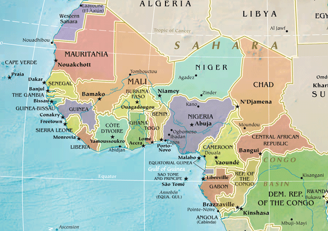
West Africa is full of states or autonomous regions that, like Kuwait, seem to be enclaves carved out from larger regions willy-nilly (examples include Gambia, Equatorial Guinea, Guinea-Bissau, the Angolan region of Cabinda, and, arguably, Sierra Leone). It also has states that either have or consist entirely of narrow strips of land that were created solely to make them accessable to the Europeans from the sea (examples include Gambia again, plus Togo, Benin, and both of the Congos). And it has five different large, landlocked countries (Mali, Niger, Burkina Faso, Chad, and the Central African Republic).
From this we come to the final and perhaps most important aspect of the secession issue: transnational regionalism. It is regionalism that has, arguably, helped to keep Puerto Rico from becoming an Atlantic Hawaii: Puerto Rico is a part of a large region, Latin America, which the US in general is not a part of. Regionalism also plays a role in Spain, where the existence of the EU has helped to bolster independence movements like that of the Catalans, while the weakness of the EU limits those movements’ success. And regionalism plays a role in Iraqi Kurdistan, which has served as a leading force in the fight against ISIS’ transnational attempt at a Caliphate; ISIS recently having its largest city, Mosul, just 85 km away from Iraqi Kurdistan’s, Erbil.
If and when transnational regionalism is ever a success anywhere, it is likely to be in a region in which nationalism is itself most problematic. Given its terribly-drawn borders, that may turn out to be West Africa.
Hey all, I’ve never tried this before, but I’d like to try crowdsourcing the content on this site a bit. Specifically, I’m looking for peoples’ articles that have the title “Robots & ______”.
Ideally, I’d like people to send in more of their own articles (any word count you want!), so I can put all of them together to create a series on how robots might impact various aspects of our world.
I look forward to reading your ideas — thanks y’all!


 The North’s resources are its cheap labour, coal reserves, and land bridge linking South Korea to China and to Russia.