If extremely high taxes on greenhouse gas emissions were to be enacted worldwide, which part of Ontario would be poised to lead in terms of population growth and economic development as a result?
My guess would be St Catharines-Niagara, which at the moment is Canada’s 12th most populous census metropolitan area (just ahead of Halifax-Dartmouth), home to approximately 400,000 people.
A low-emissions city should at least a few of the following five characteristics, all of which define Niagara. One, it should be easily accessible by barge, as water remains far and away the most fuel-efficient mode of transportation. Two, it should not have much suburban sprawl. Three, it should be located close to other major cities in order to create urban economies of scale. Four, it should have a mild climate: not too cold or snowy in the winter, not too hot in the summer. And five, it should have an abundant source of clean power — and ideally also the ability to store up its energy in order to assist clean but intermittent power sources like solar, wind, and run-of-river hydro.
1. Water Transport
St Catharines-Niagara is one of only two urban areas in Canada or the US to be situated on more than one Great Lake. (The other is Sault St Marie). It links Lake Ontario to Lake Erie via the Welland Canal, a canal 43 km long and, in most places, 100-150 metres wide. The canal has seven locks on its northern end and one lock on its southern end; it takes ships around 10 hours to cross in full. However it has a lock-free middle stretch that is close to 25 km long, next to the city of Welland (pop. 50,000). It runs perpendicular to the Erie Canal, the longest shipping canal in the United States, which links Niagara Falls and Buffalo to New York City and Lake Champlain via the navigable Hudson River, passing by Rochester, Syracuse, and Albany along the way.
Canals, when they are not frozen in the winter, are in many ways the ideal form of water transportation. They lack the difficulties of rivers (bends, rapids, shallows, etc.) and seas (storms, tides, waves, etc.), and are not too wide to make building bridges or tunnels across them too expensive. According to the New York Times, “one gallon of diesel pulls one ton of cargo 59 miles by truck, 202 miles by train and 514 miles by [Erie] canal barge… A single barge can carry 3,000 tons, enough to replace 100 trucks”.
Erie Canal
As recently as the 1890s, prior to the modern age of highways, cars, and trucks, the Erie Canal allowed Buffalo to become the eighth most populous in the US and fourth most populous inland city in the US. And while Niagara never shared in Buffalo’s prominence (in part as it was too close to the US border for comfort; it was captured in the War of 1812, and became the refuge for William Lyon Mackenzie and his supporters during the Upper Canada Rebellion in 1837-38), the adjacent city of Hamilton did. Hamilton was Canada’s fourth most populous city during the 1890s, and was about half as populous as Toronto in 1870. Today, in comparison, Hamilton is only around 13 percent as populous as Toronto.
As land transport became dominant, however, Hamilton found itself blocked in by the Hamilton Harbour (which until then had been the main source of its success) as well as by the Niagara Escarpment. Toronto, in contrast, has been able to expand barrier-free, now reaching to Lake Simcoe in the north, Oshawa and Clarington in the east, and Hamilton’s suburbs in the west.
Niagara Escarpment
Admittedly, it is still quite expensive to build bridges across harbours or wide canals; they must be either high enough to let large ships pass below, or else be lift-bridges. The Welland Canal overall has two tunnels and ten bridges, all but one of which are lift-bridges. Given that the population of the region is split by the canal (St Catharines and Hamilton are to its west, Niagara Falls and Buffalo are to its east), these lift-bridges and tunnel crossings could lead to traffic bottlenecks if its population or economic activity were to experience growth.
This canal-crossing problem can be managed, however, by switching over from cars to public transit. Luckily for St Catharines-Niagara, such a switch which would be necessary anyway if greenhouse gas emissions were to be highly taxed.
Public transit, including new transit services like Car2Go, Uber, and UberPool, can allow canals to be crossed more easily via bridge or tunnel, by reducing traffic bottlenecks and by letting its passengers relax rather than drive when there are traffic bottlenecks. In addition, public transit can allow for easier canal crossings via boat, pedestrian bridge, cable car, or even ice-sled, by making transit available upon crossing. For the same reason, crossing canals will also become easier as parking apps like Rover and PocketParker become common (and if cars that come equipped with parallel parking sensors or can parallel park themselves become common), as people will be able to park a car easily on one side of the canal and then take public transit after crossing.
In the St Catharines-Niagara area, public transit will be similarly useful in helping to cross the Niagara River (which is one of the widest and, in places, the most treacherous rivers in southern Ontario), Hamilton Harbour (which has two bridges crossing it at present, and no tunnels), and perhaps even the 45 km Lake Ontario shortcut that separates St Catharines (and Buffalo) from Toronto.
2. Suburban Sprawl
St Catharines-Niagara, as well as the nearby urban areas of Hamilton and Kitchener-Waterloo, are among the cities with a relatively high population density in Canada. Kitchener-Waterloo and Hamilton have the highest population densities among urban areas in Canada apart from Toronto, Montreal, and Vancouver, according to the 2011 census, while St Catharines-Niagara has the seventh highest population density (though this does not take into account the 50,000 people living in Niagara Falls, NY).
Niagara may be particularly well-placed to benefit if suburban sprawl in general is reversed as a result of eco-taxes. This is because many of the big cities around Niagara have had their suburbs sprawl away from Niagara during their recent generations of suburbanization. As a result, a reversal of this sprawl would bring people back closer to Niagara.
Toronto has sprawled north and to a lesser extent east, away from Lake Ontario and Niagara. Northern Toronto suburbs like King city, Caledon, and Whitchurch-Stoufville tend have population densities that are far lower than in suburbs closer to the lake, like Mississauga, Oakville, and Oshawa — nearly 30 times lower in the case of Caledon compared to Mississauga. Indeed some of Toronto’s lakeside suburbs, particularly to its west (towards Hamilton and Niagara), are themselves among the cities with the highest population densities in the country. Toronto’s easternmost suburbs, on the other hand, like Clarington and Scugog, have relatively low densities too.
Buffalo’s suburbs sprawl away from the border with Niagara, meanwhile, and Detroit’s sprawl away from Windsor (which is 315 km from St Catharines). Cleveland’s suburbs away from Lake Erie, mainly to the south and west. If, then, suburban sprawl gives way to urban re-densification, it could lead to population growth along the coasts of both Lake Ontario and Lake Erie, which Niagara shares, as well as along the Buffalo and Detroit borders with Canada, which Niagara either shares or is at least not too far away from.
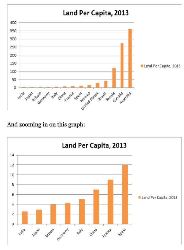
Another energy advantage of de-suburbanization is that it frees up land to be re-converted into farmland. This is important, as importing food is highly energy-intensive; food is much more bulky than most other goods, and also often requires refrigeration or freezing while it is being transported. This means that areas that are not suitable to agriculture — areas that include most of Ontario, as the Canadian Shield generally is not farmable in the economic sense — will not benefit as much from de-surbanization in an eco-tax world as areas that are best suited to be used for agriculture. For Ontario, these areas are Southwestern Ontario and adjacent lands of the United States.
3. Proximity to Major Cities
St Catharines is around 50km from Toronto by way of Lake Ontario and about 100 km from Toronto via land. To put that into perspective, Oshawa, Burlington, and Newmarket, all three of which are in the Greater Toronto Area, are around 45 km from downtown Toronto, and Barrie is around 85 km from downtown Toronto. St Catharines is also around 40 km from downtown Buffalo (and Niagara Falls is less than 30 km from downtown Buffalo), 65 km from downtown Hamilton, 120 km from Kitchener-Waterloo and from Rochester, 270 km from Cleveland, 300 km from Pittsburgh, and 320 km from Detroit, and 500 km from New York City and Washington, D.C.
St Catharine’s proximity to the New York City-to-Washington “Megalopolis” is unique and, in an eco-tax world, could be economically significant. If you extend the Megalopolis all the way north to Boston, however, then St Catharines’ proximity is less unique, as Ottawa and Kingston are both closer to Boston than St Catharines is. That said, the population density of the area between New York and Boston is quite a bit less than between New York City and Washington, so it is not clear Boston really should be counted as part of the Megalopolis core. St Catharines is also around 40 km closer to New York City and 250 km closer to Washington than Ottawa is, whereas Ottawa is only around 160 km closer to Boston than St Catharines is. Only Kingston then, among notable Ontario cities, can be said to be closer in proximity to the Megalopolis than St Catharines is.
Population density, US
4. Climate
Niagara, because of its relatively southern location and the temperate effect of the Great Lakes that surround it, has a mild climate compared to most other cities in Ontario. It tends to be around a degree warmer than Toronto in the winter and a degree cooler than Toronto in the summer, and it is much milder than the weather in more northern cities like Ottawa or Thunder Bay. It is also located outside any of the Great Lakes Snowbelts, unlike, for example, Sudbury or Barrie.
Niagara’s position next to the US border may also be significant, as eco-taxes could lead Americans to come north to where the climate is more mild, at least during the summer. The average annual daily temperature highs in Buffalo is 14 degrees celsius, compared, for example, to 29 degrees for Miami or 31 degrees for Phoenix. Cool climate zones may also end up using more eco-friendly energy for heating than hot climates do for cooling, because the weather gets coldest at night when there are typically surpluses of electricity available (including low-carbon sources, like wind, base-load nuclear, and run-of-river hydro), whereas it is hottest during the day when no such energy surpluses typically exist. Admittedly only seven percent or so of American households use electric heaters, but a high eco-tax could cause them to be adopted more widely. Plus, it is possible to stay warm using clothing and blankets rather cranking the heat.
The arid climate and diffuse population settlement in the US Southwest in particular leads to a high energy footprint. Any extended drought in the Southwest, for example, would necessitate water desalination, water treatment, or increased food imports, all three of which are extremely energy-intensive. The most extreme of these, Las Vegas, which is a gambling and tourism competitor of Niagara to a certain extent, relies on long-distance air travel, long-distance food imports, air conditioning during the day, and heating at night (the desert can get cold at night, after all).
Owning, renting, or Airbnb-ing a home or cottage in upstate New York or upstate Pennsylvania, in contrast, will help keep air conditioning costs down in summer. Moreover, because both are located in the Great Lake Snowbelts and Appalachia, these also be used recreationally during the winter. This may be an advantage too, given that eco-taxes will make it far more expensive to fly to the Rockies to ski, and given that aging Baby Boomers are going to be switching from downhill skiing to cross-country skiing. Similarly, eco-taxes could make Canadian vacationers who head south to escape the winter forgo flying to places like Arizona, California, and Mexico, and instead travel by train or bus to the US Southeast (and perhaps from there on by cruise or plane to islands in Cuba or the Bahamas). Such train and bus journeys will usually pass through Niagara.
Great Lake SnowbeltsUS average annual snowfall map
5. Energy Production
In a world in which greenhouse gas emissions are highly taxed, it would no longer be viable for Ontario to import so many manufactured goods from Asia, since Asia is so far away and relies on burning coal to power its industrial activity. Ontario would instead have to manufacture more products locally, making up for its lack of low-wage labour by using machines, having foreign engineers and other skilled labour e-commute from afar, etc. Such industrialization, particularly as it will depend on machines to assist or replace human workers, will need a lot of low-carbon energy. Niagara Falls hydro (not counting the American side of the border) accounts for around 5-6 percent of Ontario’s power generation capacity, but more than 7 percent of non-fossil fuel generation capacity and more than 20 percent if you also ignore nuclear power. Niagara accounts for about a quarter of all Ontario hydropower, and its dams also happen to be located far further south than the majority of other dams in the province or country, meaning that the energy and capital used to maintain Niagara’s dams (and to maintain the electricity grid infrastructure that is connected to them) tends to be less than it is for other hydroelectric facilities. Most of Ontario’s other dams are either located near to or north of Ottawa – far north, in many cases – while most of the hydropower in the country comes from central or northern Quebec.
In addition, the hydropower facility on the US side of Niagara Falls produces 25 percent more power than those on the Canadian side of the Falls; it produces more power than all but three other dams in the United States and accounts for nearly 60 percent of New York state’s hydropower (and New York ranks third in hydropower among US states). It also has a pumped storage capability that by itself is larger than the hydropower storage available in all of Ontario outside of Niagara, which is significant since hydro-storage remains the leading method of assisting intermittent energy sources like wind and solar. (Batteries are still not generally up to the job of storing energy in a cost-effective or eco-friendly manner, in spite of all the hoopla surrounding Tesla).
Niagara is, similarly, home to nearly all of Ontario’s pumped storage hydro capacity. Moreover, it is located relatively close to the pumped storage facilities across the United States (apart from the pumped storage in California, but those have been under-utilized in recent years as a result of drought), not just those on the US side of Niagara Falls.
Niagara is also, along with the rest of Southwestern Ontario and the adjacent Bruce Peninsula, home to most of the province’s wind power production and solar power potential.
While 60 percent or so of Ontario’s electricity comes from nuclear, people do not want to live in urban areas that contain nuclear facilities. In addition, more than half of Ontario’s nuclear power capacity is located directly on the coast of Lake Ontario, 30-60 km east of downtown Toronto, which means that, when you combine their output with that of Niagara’s dams (not even counting the US Niagara dams), the coastlands of western Lake Ontario account for more than 40 percent of Ontario’s non-fossil fuel power capacity and nearly 40 percent of Ontario’s overall power capacity.
If, finally, you look at natural gas storage – both underground storage and LNG storage – Niagara is also well-placed. Natural gas could be useful in assisting intermittent sources like solar and wind, because like hydro, but unlike coal or nuclear, a gas-fired power plant can ramp up and down energy rapidly in response to the wind suddenly slowing or the sun suddenly being blocked by clouds. Most US underground storage is surrounding Niagara, in a broad sense.
In Ontario, which in contrast to the US has very little gas storage capability, much of the gas storage is around Sarnia, with potential further development in Goderich, both of which are not too far away from Niagara. Most LNG storage and peakshaving capacity, meanwhile — which, while smaller in scale than underground storage, is better for delivering gas quickly in order to assist wind or solar intermittency — is located mostly on the Northeast coast, much of it within New York state.
The gas pipelines that bring US gas to Ontario also mainly run through or near to Niagara. Ontario used to get its gas from Western Canada, but with the shale boom in nearby US states, particularly in Pennsylvania which has led the shale gas boom, the province has begun to use US gas instead. The shale boom has revolutionized the gas industry, and should it continue it may be likely to put the border areas of Ontario in a strong position relative to non-border areas, in terms of their energy economics.
The Ontario government recently announced a plan to subsidize electric cars by up to $14,000 per vehicle and pay for them to be charged at night, among other things. Night-time charging is a key factor in electric vehicle ownership, as in most cases it takes several hours to charge an electric car.
This begs the question: what will the price of overnight electricity in Ontario be in the years ahead?
Today overnight electricity is cheap because most nuclear power plants in Ontario and coal plants in nearby states like Michigan cannot easily be turned off at night, in contrast to gas plants or hydropower facilities which can more easily ramp up and down their output to match real-time electricity demand. An estimated 60 percent of Ontario’s power is generated from nuclear, compared to around 15 percent in Canada as a whole and 20 percent in the US. Around 50 percent of the power in Michigan, Pennsylvania, Ohio, Indiana, and Illinois (states that are close to Ontario) comes from coal, compared to 33 percent in the US as a whole and 10-15 percent in Canada. Ontario and the Midwest are also among the leaders in wind turbines, which do not turn off at night either, and Ontario, Illinois, and Pennsylvania are by far the top three North American producers of nuclear power.
Going forward, however, there are compelling reasons to think that this overnight surplus of electricity will no longer exist.
The first reason is fracking. In the past few years the US has seen an enormous boom in shale gas production, which has been leading much of the country to begin switching off their coal plants and replacing them with cheap natural gas. The stock prices of US coal companies have already dropped by over 90 percent since 2014, and by over 97 percent since 2011. As more gas and less coal is used to generate electricity, the price of overnight electricity is likely to spike relative to the price of daytime electricity, since gas plants tend to be far easier to shut off at night than coal plants.
The second reason overnight electricity prices are likely to rise is robots. Machines that combine mobility with computation are highly energy-intensive, but, unlike humans, they do not need to sleep at night or relax in the evening. Take, for example, Amazon’s robotic warehouses: they have caused the company’s night-time electricity use to rise substantially since they were introduced, given that before they came along Amazon’s warehouses were either inactive overnight or else employed human workers who ran on food (and overtime pay) instead of electricity. If and when this robotic economy finally goes mainstream, then, such demand for overnight power could be replicated at large. We should expect late-night electricity use to skyrocket: robots are no longer science-fiction.
The final reason is environmentalism. In order to keep greenhouse gas emissions down (which is, after all, the main point of subsidizing EVs), many voters are pushing for more solar panels and wind turbines to be built. Solar and wind are complementary to one another, not only because the sun often shines brightly at different times as the wind blows strongly, but also because wind farms and solar farms usually inspire non-overlapping types of NIMBY-driven political backlash. Ontario already gets 5-6 percent of its electricity from wind compared to less than one percent from solar, so it might be that going forward its solar power growth will outstrip its wind power growth. Of course, solar power will not help to bring down overnight electricity prices. Even the wind, however, tends to blow less strongly overnight than during the day – a fact that runs contrary to conventional wisdom, since the wind can usually be heard more clearly at night.
As solar, wind, and gas replace dirtier coal in the regional electricity network, there will also be environmentalist-led pressure to stop heating homes with fossil fuels and instead adopt electric-powered heaters like those used in Quebec and the Pacific Northwest. This too would be likely to cause overnight electricity prices to rise. Quebec, for example, uses electric-powered heating and so has its electricity demand peak during frigid winter nights, whereas Ontario primarily uses gas-powered heating and therefore has its electricity demand peak during hot summer days. Should Ontario or nearby US states switch over to electric heating in order to reduce carbon and methane emissions from natural gas, the region’s overnight electricity usage will rise.
The need to help support solar and wind power could lead as well to the building of more pumped-hydro facilities, which pump water uphill so that it can flow back downstream through a turbine when other power sources are in low supply, such as when solar panels are blocked by clouds or the wind is not blowing. There has been talk lately of building more pumped hydro in Ontario, in places like Niagara and Marmora, as pumped hydro is the most efficient form of electricity storage. Given that Ontario’s daytime power is not cheap (at least, not by Canadian or American standards), this water would be pumped at night. It is an energy-intensive process, however, requiring 20 percent or so more energy to pump uphill than is generated from releasing it back downhill. Thus it would lead overnight prices to rise.
In closing, any electric-vehicle policy approach that assumes that Ontario’s overnight electricity costs will remain cheap is probably a shortsighted one. Ontario’s overnight electricity costs are likely to rise substantially as a result of natural gas replacing coal, robots working slavishly every night, and the move towards cleaner sources of energy like wind power and, especially, solar power.
Without being certain of future electricity prices, the EV subsidy plan is like a leap, or Leaf, in the dark.
Source: Royal Bank of Canada, predictions of provincial economic growth for 2015, published March 2015
With the economy of Western Canada hit hard by the fall in oil and other commodity prices that began last year, Canada’s most populous province, Ontario, has begun to account for quite a large share of the country’s economic growth. Many Canadian economists – most of whom live in Ontario, as I do – assume this economic resilience is the result of Ontario’s economic diversity and size. Ontario’s population is much larger than that of any other Canadian province (see graph below), and its economy is mixed between services (in Toronto), government (Ottawa), industry and agriculture (southwestern Ontario), and commodities (northern Ontario). Ontario’s economy is also more oriented toward the auto sector than other provinces are, and so may be benefiting more than others from the fall in oil prices.
Ontario accounts for around 38 percent of Canada’s population, compared to 23 percent for Quebec and 13 percent for British Columbia. Most other countries do not have provinces/states that are as large as this. California, for example, is the largest state in the US but has just 12 percent of the US population; source: Future Economics
Still, this may be missing the point to a certain extent. What really sets Ontario aside from other Canadian provinces is the proximity of large population centres in Ontario to large population centres in the United States. This is unique among Canadian provinces (see graph below), particularly if you ignore Quebec (which is separated from US populations by a language barrier as well as a political one) and British Columbia (which, perhaps not incidentally, is the other major province that has decent economic growth right now, in spite of the fact that it is a significant commodity exporter and has close ties to oil-rich Alberta). Ontario is the only province to have a handful of cities which straddle the US-Canada border. These include Detroit-Windsor, Buffalo-Fort Erie, Niagara Falls, Sault St Marie, and Sarnia-Fort Huron.
Since the US economy has remained relatively strong in recent years, unlike those of Europe, East Asia, or much of the developing world, Ontario’s ties to the US may be what is driving Ontario’s economic growth. This should make Ontario concerned; the US economy has not had a recession for almost eight years now, so, in a certain sense at least, it is due for one soon.
Below, I have tried to show some of the ways in which Ontario’s proximity to the US is unique. I’ve gathered all the data myself using Google Earth and recent Canadian and American censuses, so if you think you’ve found any errors in the following graphs please let me know.
[New Brunswick had zero in this category because Maine’s economy has been neither growing nor shrinking in the past year or so. Alberta and BC are high in this category because of the growth of Washington state and Montana, respectively. Saskatchewan and Manitoba were doing great in this category before the oil crash caused their shared neighbour North Dakota to go from the fastest-growing US state into a serious recession. Ontario and Quebec are roughly equal in this category because of the huge size of New York state, which they both border. However if you were to ignore New York state, then Ontario’s border states, namely Michigan and Minnesota, are growing much faster than Quebec’s border states, namely Maine, Vermont, and New Hampshire. Minnesota’s growth, meanwhile, is also why Manitoba is relatively high in this category in spite of North Dakota’s recession — as Minnesota’s GDP is nearly seven times higher than North Dakota’s]Ontario’s ties to the US have also meant that it is less dependent on inter-provincial trade of goods than other parts of Canada are: in recent years Ontario has conducted 2.5 times more trade with other countries (led by the United States, of course) than it has with other provinces. This is compared to just 1-1.5 times more for Quebec, Alberta, and British Colombia.
Economists and financial journalists in Ontario need to be more careful than they have been in the recent past. During the 2007-2009 economic crises they ascribed the relative success of Canada’s financial system (which is centred in Toronto, Ontario) to the fact that Canadian bankers and regulators were more prudent and conscientious than their peers in other countries, rather than to the fact that Canada was flush with capital at the time as a result of the sky-high commodity prices that existed just before and just after the financial crisis, and as a result of the fact that Canadian Baby Boomers were then in the prime of their financial lives (as Canada, unlike the younger US or older Japan, is dominated by the Baby Boomer generation).
But instead of acknowledge these facts, much of the Canadian media decided instead to help create a cult of personality around Canadian bankers and Bank of Canada leader Mark Carney — a cult of personality they have since exported to Britain, where Carney has become a figure of great importance (especially since Brexit and the resignation of Prime Minister David Cameron) and the first non-Briton to ever become the central banker over the British financial system, a system that is far larger, far more worldly, and far less dependent on commodity sectors than the Canadian financial system is. Similarly, Ontario’s economic resilience is now being described (by some people) as if it was basically an inherent condition of the Ontario economy, rather than a result, at least in part, of Ontario’s unique ties to the growing US economy.
Don’t get me wrong: I am not saying that Ontario is not a resilient place or that bankers and regulators in Toronto and Ottawa are not prudent and wise. And certainly I would like Ontario’s economy to continue growing, since it is my home. However, believing either one of these stereotypes about Ontario too much could be a dangerous mistake for investors or governments to continue to make.
It used to be, roughly speaking, that labour + energy = industrial output = military power.
This made Iran the natural power in the Middle East. Iran had far more energy than countries like Turkey, Egypt, Israel or Pakistan, and far more labour than the Gulf Arab countries or Libya:
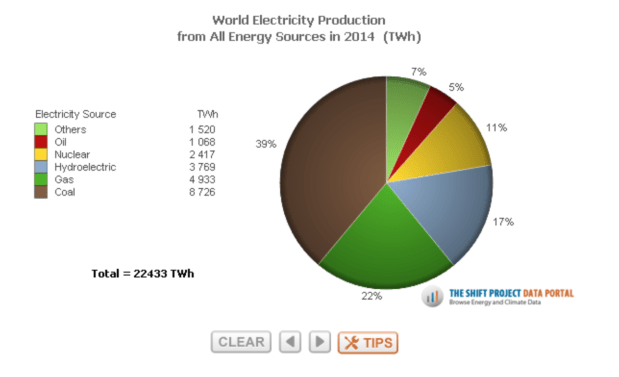
X-axis is population size, Y-axis is the value of energy reserves as estimated by Business Insider in 2014
X-axis is population size, Y-axis is energy production in 2014 as estimated by Shift Data Portal. Saudi Arabia leads Iran in energy production, but the Saudis have had the benefit of having an alliance rather than a rivalry with the United States
The Gulf Arab monarchies have tried to overcome their relative deficit in labour by importing workers from Asia. However there are limits to such immigration, not only because of the fear that the immigrants could cause political instability (they are mostly men, and tend to be poorly treated), but also because it is not cheap to provide food and water in the desert.
The US has often worked to influence or contain this Iranian potential. It pressured the Soviets and British to withdraw from Iran following World War Two, helped to overthrow Iran’s Prime Minister in the 1950s, helped to unleash the Arabs on Iran in the Iran-Iraq War of the 1980s, and in recent years has opposed the Iranian-allied regime in Syria and played Good Cop-Bad Cop along with the Israelis in threatening to carry out airstrikes on Iran’s nuclear and military infrastructure.
Going forward, however, the traditional relationships between labour, industry, and military power may be breaking down.
Labour may no longer be so important to industry, as industrial labour will in many cases be replaced by machines or, in the case of skilled labourers like engineers and computer programmers, may sometimes be outsourced using high-quality digital communications. Having a large labour force may perhaps even limit the ability to industrialize, since countries with large populations could have to deal with robot-caused unemployment, competition for energy between the residential, commercial, and industrial sectors of the economy, and protests against local industrial pollution. This could put the Gulf Arab states at less of an industrial disadvantage when compared to countries with larger labour forces, like Iran.
Meanwhile, industrial output and labour are both less likely to translate into military power than they once were. In past wars, like the Iran-Iraq War or the Israeli-Arab Wars, wars were fought by giving lots of soldiers lots of weapons. This is, for example, one reason why the Israeli-Arab wars never lasted long. Israel did not have a large enough population to run its military and factories at full capacity simultaneously, so it had to end wars quickly in order to avoid running short on supplies. Otherwise it would risk becoming too dependent on US supply lines, as arguably occured when it was attacked by Egypt and Syria during the 1973 Yom Kippur War.
In the future, though, human soldiers may be replaced by machines in some cases, rendering population size less important in war. In addition, the quantity of weapons produced could continue to become less significant than their quality, given that weapons can now be destroyed by precise satellite-guided missiles. As a result, if the Gulf Arab states and Iran were to use their oil and natural gas reserves to become industrial powers, it would not have to translate into their becoming military powers. This could make existing Middle Eastern military powers like the US, Turkey, or Israel more likely to tolerate the industrialization of the Gulf.
The machine-driven industrialization of the Gulf Arab states and Iran could make sense for a number of other reasons as well:
— The Gulf region is even less populous than it may seem at first glance. This is because the vast majority of the populations of Iran, Saudi Arabia, and to a lesser extent Iraq live hundreds of kilometers away from the Gulf, and separated from the Gulf by mountains and desert. If you count only the provinces of Iran, Saudi Arabia, and Iraq that border the Gulf, the entire population of the Gulf region (including the smaller Gulf Arab states) is only around 30-35 million. It is also very hot there during the day, making physical labour difficult.
(Population Density of Saudi Arabia and Iran)
Topography of the Gulf (Iran is on the right-hand side); many of these mountains are as high as the Alps
— The Gulf region is rich not only in oil, but also in natural gas. Iran in particular is the world’s third largest producer of natural gas, and is thought to have the second largest reserves (the largest by far if you do not count Siberia). Iran also directly borders landlocked Turkmenistan, which is thought by some to have the world’s fourth largest gas reserves.
Natural gas, however, is very difficult to transport long distances or to store up in large quantities. Qatar has managed to become rich from exporting its gas in liquified (LNG) form, but this only works because Qatar has a tiny population (2.3 million people) and as LNG prices in Asia and Europe have been high. For the rest of the Gulf’s gas, it would be difficult to replicate Qatar’s success. It might make more sense, then, for the gas to be kept within the Gulf, used there to produce energy for industrialization.
— The Gulf region is located at the centre of Eurasian and African trade routes, both by land and by sea. While all of the Gulf’s trade routes are politically fragile, this may actually make industrialization sensible, because it is easier to stockpile large amounts of manufactured goods or industrial raw materials for use during a crisis than it is to stockpile oil or especially gas. Industrialization would also give the region more economic autarky, which would be useful if its trade routes to the outside world were ever imperilled or cut. And the Gulf already possesses large industrial port areas as a result of its energy exports.
— Industrial areas which use machines can be clustered in ways that traditional, labour-based industrial areas cannot. Machines, after all, do not need lodgings, and are not bothered by pollution. Moreover, the Gulf itself could be a mega-industrial cluster, given that it has the world’s largest concentration of cheap-to-produce oil and gas by far. In other words, you might be able to have a bunch of local industrial clusters forming a huge, region-wide industrial cluster.
Industrial clustering could have a number of advantages. First, it could be easier to defend militarily, which, given the enormous expense and difficulty of missile defence systems,
could be significant. In the Gulf, the energy fields, power plants, factories, and ports could all be concentrated in a fairly small, defended area. If you ignore coal, there is nowhere else in the world that comes even close to being able to have this. (Texas is probably the closest…).
Second, clustering could perhaps help to allow for carbon capture and storage. Carbon capture and storage has thus far proven to be far from economical in most cases, and yet it is also necessary if the world wants to limit carbon emissions without ending consumption of fossil fuels. It could be that the way to make it economical is to cluster many power plants together in order to allow for economies of scale to form. Moreover, the only type of carbon capture and storage that has proven economical thus far is when carbon is used in Enhanced Oil Recovery (EOR), being sent down oil and gas wells in order to increase oil and gas productivity. The Gulf already uses EOR in some cases, and has huge EOR potential as a result of the size of its oil and gas fields.
US Oil Demand
One factor that could help spur the industrialization of the Gulf would be if people in the rich world, particularly in North America, would stop driving alone in their cars so much. By switching to alternative forms of transport — whether carpooling, taking public transport, UberPool-ing, e-commuting, shopping online, taking a self-driving bus or self-driving electric car, etc. etc. — it may leave Gulf oil available for industrial use within the Gulf.
—
Then again, maybe none of this will end up happening. The Gulf may be ludicrously rich in easy-flowing oil and gas, but translating that energy wealth into industrial success will be no easy feat, with or without robots.
Saudi Arabia has an estimated population of 32 million, the 40th largest in the world and 6th largest in the Arab world. It is barely more than a third of the size of Egypt’s population. Territorially, however, Saudi Arabia is massive. It is the 12th largest country in the world, and the largest country in the Arab world outside of Algeria. Its territory is roughly the size of Turkey, France, Germany and Japan put together.
Of course, much of this territory is desert. Saudi Arabia’s arable land per capita, according to the World Bank, is just 0.1 hectares per person. This is less even than in densely populated states like India, though it is still a lot higher than in Egypt, Yemen, and a few other Arab countries.
Most Saudis live in the western part of the country, within 150 km of the Red Sea. The densest concentration of Saudi Arabians live near the country’s mountainous border with Yemen.
Population density of Saudi Arabia by Region
On the Yemeni side of the border the population density is also high. Nearly all of Yemen’s population of 27 million lives within 400 km of this border. Many Yemenis live within just 200 km of the border, in the capital and largest city Sana’a or in the mountains north of Sana’a.
Shiite groups live on both sides of the Saudi-Yemeni border
(Another product of Yemeni-Saudi relations was Osama bin Laden, one of the many sons of the billionaire Mohammad bin Awad bin Laden, a poor Yememite who moved to Arabia’s main port city of Jeddah before the First World War, who went on to become one the richest non-royals in Saudi Arabia).
Of Saudi Arabia’s 13 Regions, Ar Riyadh, Makkah, and Eastern Province (Ash Sharqiyah) are by far the most populous. Jizan in the southwest, meanwhile, is much more densely populated than any of the others, followed by Bahah, Makkah, and Asir which are also much more densely populated than the others
The Saudi-Yemeni relationship is in some ways a microcosm of Saudi Arabian geopolitics in general. Saudi Arabia’s borderlands (the lands on either side of Saudi Arabia’s borders) are much more populous than Saudi Arabia’s heartland (the region in and around the Saudi capital city Riyadh). While the Saudi heartland adheres mainly to ultraconservative Wahabbi Islam (or, more broadly, to Sunni Islam), Saudi borderlands are often non-Sunni or adhere to more cosmopolitan (by Saudi standards) non-Wahabbist Sunni traditions.
This includes not just the wealthy, relatively cosmopolitan foreign cities of the Persian Gulf, like Dubai, Doha, or Abu Dhabi, but also cities within Saudi Arabia near the Red Sea, like Mecca and Medina (because of the Hajj, which has historically had a worldly influence) and the Meccan port city of Jeddah, which is by far the most populous Saudi city apart from Riyadh.
Within 200 km of Saudi Arabia’s land borders, over 35 million people live (not counting Saudi Arabia’s own population), more than the 32 million people that live in Saudi Arabia. Within 500 km of Saudi Arabia’s land or sea borders more than 230 million people live (not counting Saudis). By comparison, there are just 15 million or so people who live in or within 500 km of Riyadh.
In contrast, in Egypt most of the Egyptian population lives in or within 200 km of Cairo, and very few people in Egypt live within 200 km of Egypt’s land borders with other countries. In Turkey most people live in or within 400 km of the capital Ankara. In Iraq nearly all people live in or within 430 km of Baghdad. And in Pakistan most people live within 500 km of Islamabad.
Iran, on the other hand, does have a somewhat similar geopolitical configuration as Saudi Arabia, if not necessarily to the same extreme. The Iranian heartland (in, around, and between the cities of Tehran and Esfahan) is far away from most the country’s populous borderlands, and its borderlands are in many cases not inhabited by Persians but rather by minority groups like Kurds, Arabs, Azeri Turks, Balochis, and others. The fact that both Saudi Arabia and Iran are potentially fragile in this way has helped, perhaps, to drive their rivalry with one another, as both act aggressively to preempt any perceived threats to their internal cohesion.
One of the only significant exceptions to Saudi Arabia’s borderland permeability is in its southeast, where the Empty Quarter of the Arabian desert effectively hives off areas within Oman, the UAE, and Yemen from Saudi population centres. You can see the influence of the Empty Quarter (Ar Rub’ al Khali) in the map of roads in Saudi Arabia below: it has almost none. According to Wikipedia, the Empty Quarter is larger in size than entire countries like France, Afghanistan, or Ukraine. It is about five times larger than England.
Looking out from Riyadh, the Saudi leadership sees potential border-region threats in almost every direction. It worries not only about neighbouring countries, but also how they may interact with its own Saudi citizens (and with its foreign-born labourers, who number around a fifth of the people in Saudi Arabia). In the past the Saudis have waged an aggressive foreign policy meant to stave off such threats, for example allying with the US during the Cold War in order to combat the Shiite Iranians (post-1979), the Pan-Arab Nasserites in Egypt (pre-1980), and Ba’athist Iraq (in 1990).
Today Saudi Arabia continues to project influence, in various ways, into countries like Egypt (where it supported ultra-religious Salafist political parties and the Egyptian military against both the Muslim Brotherhood and Egyptian liberals), Bahrain (which Saudi Arabia invaded, in effect, during the Arab Spring in 2011, in order to prop up the Sunni monarchy against the majority Shiite population), Iraq and Syria (where it has supported religious Sunni groups), Lebanon, and Yemen.
Even along its maritime borders the Saudis are potentially insecure, a result of the narrowness of the Red Sea (250 km, on average) and Persian Gulf (also 250 km wide), as well as the fact that both seas can be potentially closed off because of the chokepoints of Hormuz, Suez, and the Bab-el Mandeb. Indeed, absent support for Saudi Arabia from an outside power like the United States, the most probable leading nation in the energy-rich Persian Gulf is not Saudi Arabia, but rather is Iraq, which occupies a large majority of the arable lowlands in the Persian Gulf basin, or Iran, which occupies most of the arable highlands overlooking the Persian Gulf. Saudi Arabia’s Gulf region, in contrast, is mainly desert.
In addition, because Iran and Iraq are both majority-Shiite, as is Saudi Arabia’s Eastern Province and neighbouring Bahrain, the Sunnis and Wahabbists in Saudi Arabia are at a potential disadvantage in the Gulf region from a religious perspective. Indeed, Saudi Arabia is badly outnumbered in the Gulf even just by the Kuwaitis, Qataris, and Emiratis, who together have 15 million inhabitants (led by the Emiratis, with 9.5 million people) and an estimated GDP of 775 billion dollars (compared to around 750 billion dollars for Saudi Arabia). This situation is further complicated by the huge foreign-born labour forces of these rich Gulf monarchies, which tend not to be treated very well yet outnumber the citizen labour forces within most of these countries.
Historically the Persian Gulf was not as important as it is in the modern oil and gas era. The Saudis main rivalries in the late 19th and early 20th century were instead in western Saudi Arabia, with the Hashemites, and in north-central Saudi Arabia, with the Rashidis. The Hashemites, who had been allied with the British and today rule Jordan, were in control of the Hejaz (see map below) until defeated and exiled to (rule) Iraq, Syria, and Jordan by the Saudis in 1924-1925; the Rashidis, who had at times been allied with the Turkish Ottomans, were in control of most of the Arabian interior until defeated by the Saudis in 1921, three years after the end of the First World War. Just thirty-one years before, in 1890, the Rashidis had conquered Riyadh and forced the Saudis into political exile in Bahrain, Qatar, and Kuwait.
Today most of Saudi Arabia’s population lives in the Hejaz, in lands that have been under Saudi rule for less than a century. The legacy of the rivalry between the Saudis and Rashidis, meanwhile, can still be seen in the M. Izady relgious map (posted higher above in this article), where the area in, around, and north of the city of Ha’il, the former Rashidi capital, is one of the only parts of the Saudi interior categorized as Sunni rather than Wahhabi. The defeat of the Rashidi dynasty has meant that Ha’il is now just the 12th most populous city in Saudi Arabia, in contrast to Riyadh which has become the largest in the country.
Mecca and Medina
Mecca is just the third most populous Saudi city, however because of its religious significance it is more important than any other. It is located close to other large Saudi cities: 65 km east of Jeddah (the second largest Saudi city, with more than twice the population of Mecca), 50 km west of Taif (the sixth largest Saudi city) and 335 km south of Medina (the fourth largest Saudi city). Together Mecca, Jeddah, and Taif, all of which are located in Makkah Region, have a population larger than the Saudi capital Riyadh or the Riyadh Region.
Mecca is located almost exactly on a straight line with Riyadh in central Saudi Arabia (I’ve added lines on the map above to try to display this), with Hofuf and Dammam in eastern Saudi Arabia (the fifth and seventh largest Saudi cities, respectively), and with Manama (Bahrain’s capital) immediately to Saudi Arabia’s east. This line is perpindicular to the line that runs north-south along the western coast and coastal mountains of Arabia.
Within these lines, which converge around Mecca, Jeddah, and Ta’if, lives a significant majority of Saudi Arabia’s population, as well as most Yemenis and Bahrainis. Cities like Medina, meanwhile, are outside but still quite close to these lines, as is Doha the wealthy capital of Qatar. The north-south line also runs roughly parallel to the Nile river valley, where nearly all Egyptians and most Sudanese live.
Historically Mecca and Jeddah were strategically located, at the centre of the regional trade and transport routes linking Asia, Europe, and East Africa. They are situated almost exactly 1200 km from the Indian Ocean, Mediterranean, and Persian Gulf. Because Mecca and Jeddah are located just to the north of the higher elevations of Arabia’s Red Sea coastal mountains (see maps below), and northwest of the impassable Empty Quarter of Arabia, caravan routes between the Persian Gulf and Red Sea could not easily bypass them to the south.
the stronghold of Ta’if
At the same time, Mecca still has a useful foothold in a small northern sliver of these higher-elevation coastal mountains, around Ta’if. Ta’if, where Meccan elites historically would reside during the summer to escape the heat, is at 1879 metres above sea level, compared to just 12 metres for Jeddah, 277 for Mecca, and 332 for Medina.
The relative proximity of Mecca, Jeddah, and especially Medina to Egypt was also significant in the past. Before steamships, it was difficult to travel northward in the Red Sea because of the trade winds blowing south and the rockiness and narrowness of the Gulf of Suez. As a result, ships would often travel instead to the Egyptian port city of Al-Qusayr (population 50,000 today) where a bend in the Nile brings the river relatively close to the Red Sea, then cross 155 km of desert overland to Quena (population 250,000) on the Nile and sail the river the rest of the way to the Mediterranean.
Al-Qusayr to Quena
Unlike the Red Sea, the Egyptian portion of the Nile could be crossed easily in either direction; it has no significant rapids or water-barriers to the north of the Cataracts of the Nile (which separate Egypt from Sudan), it has no significant river bends (unlike the very big bend the Nile makes in Sudan north of the capital Khartoum), and even sailing south against the current of the river could be acheived with relative ease because of the south-blowing trade winds. The Egyptian port of Al-Qusayr on the Red Sea is not too far north of Medina, and is likely one of the reasons that Medina became so significant.
In addition, Medina is located near where the Wadi Al-Rummah, the longest valley in the entire Arabian peninsula, arises. It runs from Medina all the way northeast to the Persian Gulf by Kuwait.
Jeddah and Mecca, meanwhile, are across from Port Sudan, which is by far the most populous coastal city on the Red Sea in either Sudan or Egypt (not counting Suez). From Port Sudan a valley leads through the East African coastal mountains to the Sudanese capital of Khartoum (population 5-6 million), where the Blue Nile and White Nile meet to become the Nile. Today Khartoum is perhaps the fourth or fifth most populous city in the Arab world, but gets little media attention.
The routes between Arabia and the Nile were used, for example, during the late 18th century, when the British sent their army from India to Egypt to counter the invasion of Egypt and Palestine by Napoleon, when Napoleon was still a general and not yet France’s ruler. The route was used also by the sons of Egypt’s Ottoman Viceroy Muhammad Ali to overthrow the First Saudi State (1744-1818) and later challenge the Second Saudi State (1824-1891). However as a result of modern shipping and the Suez Canal, the route today is no longer as important.
Conclusion
Saudi Arabia’s geography has heavily informed its history, up to and including the present day. As a result of its desert climate, for example, the Saudi economy is still not very large. Its GDP is estimated to be smaller than Turkey’s, a third as large as Italy’s, and less than twice as large as those of Iran or the United Arab Emirates. Politically, meanwhile, the strain between the historical Saudi and Wahabbi heartland around Riyadh and its borderlands around the Red Sea and Persian Gulf is perhaps the main factor driving the Saudi state’s aggresivity and extremism, both at home and abroad. This aggressivity and extremism, in turn, could create political pushback against the Saudi leadership from Saudi citizens, neighbouring Middle Eastern countries, or external powers like the United States.
————–
Some notes, taken from Wikipedia:
The Rashidis
“As with many Arab ruling dynasties, the lack of a generally accepted rule of succession was a recurrent problem with the Rasheedi rule. The internal dispute normally centered on whether succession to the position of amir should be horizontal (i.e. to a brother) or vertical (to a son). These internal divisions within the family led to bloody infighting. In the last years of the nineteenth century six Rasheedi leaders died violently. Nevertheless, The Al Rasheed Family still ruled and fought together [against the Saudis] in the Saudi–Rashidi Wars.”
As an aside, Faisal bin Musa’id, a half-Rashidi half-Saudi prince, assisinated Saudi Arabia’s King Faisal in 1975. According to Wikipedia, “Faisal’s father was Prince Musa’id, the step-brother of King Faisal, and his mother was Watfa, a daughter of Muhammad bin Talal, the 12th (and last) Rashidi Emir. His parents divorced. He and his brothers and sisters were much closer to their maternal Rashidi relatives than their paternal Al Saud relatives. In 1966, his older brother Khaled, a Wahhabist, was killed during an assault on a new television station in Riyadh. Wahhabi clerics opposed the establishment of a national television service, as they believed it immoral to produce images of humans. The details of his death are disputed. Some reports allege that he actually died resisting arrest outside his own home. Faisal came to the United States in 1966 and attended San Francisco State College for two semesters studying English. Allis Bens, director of the American Language Institute at San Francisco State, said, “He was friendly and polite and very well brought up it seemed to me. I am really very surprised about this.” While Faisal was at San Francisco State his brother Khaled was killed. In 1969, while in Boulder he was arrested for conspiring to sell LSD. He pleaded guilty and was place on probation for one year. After leaving the United States, he went to Beirut. For unknown reasons, he also went to East Germany. When he came back to Saudi Arabia, Saudi authorities seized his passport because of his troubles abroad. He began teaching at Riyadh University and kept in touch with his girlfriend, Christine Surma, who was 26 at the time of the assassination.On 25 March 1975, he went to the Royal Palace in Riyadh, where King Faisal was holding a majlis. He joined a Kuwaiti delegation and lined up to meet the king. The king recognized his nephew and bent his head forward, so that the younger Faisal could kiss the king’s head in a sign of respect. The prince took out a revolver from his robe and shot the King twice in the head. His third shot missed and he threw the gun away. King Faisal fell to the floor. Bodyguards with swords and submachine guns arrested the prince. The king was quickly rushed to a hospital but doctors failed to save him. Before dying, King Faisal ordered that the assassin not be executed.. Saudi television crews captured the entire assassination on camera. A sharia court found Faisal guilty of the king’s murder on 18 June, and his public execution occurred hours later. His brother Bandar was imprisoned for one year and later released. Following the execution, his head was displayed to the crowd for 15 minutes on a wooden spike, before being taken away with his body in an ambulance. Beirut newspapers offered three different explanations for the attack. An-Nahar reported that the attack may have been possible vengeance for the dethroning of King Saud, because Faisal was scheduled to marry Saud’s daughter — Princess Sita — in the same week.”
The First Saudi State
“After many military campaigns, Saud [the founder of First Saudi State] died in 1765, leaving the leadership to his son, Abdul-Aziz bin Muhammad [who married the daughter of Muhammad ibn Abd al-Wahhab, the founder of Wahabbism]. Saud’s forces went so far as to gain command of the Shi’aholy city of Karbala [in Mesopotamia] in 1801. Here they destroyed grave markers of saints and monuments. [Later they] sent out forces to bring the region of Hejaz under his rule… This was seen as a major challenge to the authority of the Ottoman Empire, which had exercised its rule over the holy cities since 1517. The task of weakening the grip of the House of Saud was given to the powerful viceroy of Egypt, Muhammad Ali Pasha, by the Ottomans This initiated the Ottoman–Saudi War, in which Muhammad Ali sent his troops to the Hejaz region by sea. His son, Ibrahim Pasha, then led Ottoman forces into the heart of Nejd [the interior of Arabia]… Finally, Ibrahim reached the Saudi capital at Diriyah [on the outskirts of Riyadh] and placed it under siege for several months until it surrendered in the winter of 1818. Ibrahim then shipped off many members of the clans of Al Saud and Muhammed Ibn Abd Al Wahhab to Egypt and the Ottoman capital, Constantinople. Before he left he ordered a systematic destruction of Diriyah, whose ruins have remained untouched ever since. Abdullah bin Saud was later executed in the Ottoman capital Constantinople with his severed head later thrown into the waters of the Bosphorus, marking the end of what was known as the First Saudi State.”
The Second Saudi State
“The first Saudi to attempt to regain power after the fall of the Emirate of Diriyah in 1818 was Mishari ibn Saud, a brother of the last ruler in Diriyah, Abdullah bin Saud. He was soon captured by the Egyptians and killed, however. In 1824, Turki bin Abdullah bin Muhammad, a grandson of the first Saudi imam Muhammad bin Saud, was able to expel Egyptian forces and their local allies from Riyadh and its environs. He is generally regarded as the founder of the second Saudi dynasty as well as being the ancestor of the kings of modern-day Saudi Arabia. He made his capital in Riyadh and was able to enlist the services of many relatives who has escaped captivity in Egypt, including his son Faisal ibn Turki Al Saud. Turki was then assassinated in 1834 by Mishari ibn Abdul-Rahman, a distant cousin. Mishari was soon besieged in Riyadh and later executed by Faisal, who went on to become the most prominent ruler of the Saudis’ second reign. Faisal, however, faced a re-invasion of Najd by the Egyptians four years later. Faisal was defeated and taken to Egypt as a prisoner for the second time in 1838. The Egyptians installed Khalid ibn Saud, last surviving brother of Muhammad bin Saud, who had spent many years in the Egyptian court, as ruler in Riyadh, and supported him with Egyptian troops. In 1840, however, external conflicts forced the Egyptians to withdraw all their presence in the Arabian Peninsula, leaving Khalid with little support. Seen by most locals as nothing more than an Egyptian governor, Khalid was toppled soon afterwards by Abdullah ibn Thuniyyan, of the collateral Al Thuniyyan branch. Faisal, however, had been released from prison that year and, aided by the Al Rashid rulers of Ha’il, was able to retake Riyadh and resume his rule… Upon Faisal’s death in 1865, Abdullah assumed rule in Riyadh but was soon challenged by his brother, Saud. The two brothers fought a long civil war, in which they traded rule in Riyadh several times. Muhammad ibn Abdallah ibn Rashid of Ha’il took the opportunity to intervene in the conflict and increase his own power. Gradually, Ibn Rashid extended his authority over most of Najd, including the Saudi capital, Riyadh. Ibn Rashid finally expelled the last Saudi leader, Abdul-Rahman bin Faisal, from Najd after the Battle of Mulayda in 1891, ending the Second Saudi State.”
As a result of the conflicts in Syria and Libya, Morocco has become the only state in the Middle East/North African region that is not or does not border a failed or semi-failed state.
Morocco’s next-door neighbour Algeria, in contrast, borders two or three such states, namely Libya, Mali, and Niger. Algeria might also be standing on politically shaky ground itself, as its economy is highly dependent upon exports of oil and gas and as its leader Abdelaziz Bouteflika, who has governed the country since 1999 (since the Algerian Civil War, which lasted from 1991-2002), has now reached 79 years old and has very serious health problems but no clear political successor.
Tunisia, meanwhile, in sandwiched narrowly between Libya, Algeria, and the depressed economy of southern Italy. Egypt borders Libya and Sudan and Gaza. Saudi Arabia borders Iraq and Yemen. Iran borders Iraq and Afghanistan. Turkey borders Iraq, Syria, and the economy of Greece. Sudan borders several troubled states and also remains troubled itself. Jordan borders Syria and Iraq. Lebanon borders Syria. Kuwait borders Iraq. Oman borders Yemen.
The West Bank Palestinian Territory, like Morocco, does not have failed-state neighbours: it is directly bordered only by Israel and Jordan. Still, Palestine cannot be said to be on this list with Morocco, since it is not independent and since it includes the more troubled Gaza Strip. Qatar, the United Arab Emirates, and Bahrain, meanwhile, are no longer truly majority-Arab economies, as non-Arab foreign workers now significantly outnumber their own citizen labour forces.
Morocco is an outlier also in terms of its economy (it is a significant net importer of fossil fuels, unlike most other Arab economies) and in its geographic location at the outer edge of Africa and Europe. Though Morocco has not been able to capitalize much on these traits in the past – the country’s per capita GDP is under $4000 – there are reasons to think that it will begin to outshine most other nations in the coming years.
Here are 5 factors to keep an eye out for:
1. Ties to the Americas
Morocco has closer connections to the Western Hemisphere than do most other countries in the Arab world, for a number of reasons. One is geography: Morocco is an Atlantic country, and most people in North and South America live within the Atlantic basin. Marrakesh is 5900 km from Manhattan, 6900 km from Miami, and 4900 km from the easternmost edge of Brazil. By comparison, Marrakesh is 5400 km from the Saudi capital Riyadh, 4900 from Baghdad, and 3700 km from Cairo.
Another is language: millions of Moroccans can speak French, Spanish, or (increasingly) English, which along with Portuguese are the languages spoken most often in the Americas.
Another is history: Morocco was not a British colony, so it does not have the same resentment against the English-speaking world that many other countries do. Also, it was liberated by the US and Britain relatively early on in the Second World War (insert Casablanca reference here).
And another is politics: the US wants at least one stable, large, non-Wahabbist political ally in the Arab world, and as a result it is views Morocco favourably. In addition, the US and British navies continues to require passage through the narrow Strait of Gibraltar between Morocco and Spain in order to access the Mediterranean.
(Morocco and the US struck a Free Trade Agreement in 2006. Outside of Canada, Australia, South Korea, Israel, Jordan, Oman, and some countries in Latin America, Morocco is the only country to have such an agreement with the US)
As the economies of Europe, East Asia, and most of the developing world are simultaneously struggling at the moment, whereas the economy of the United States remains relatively vibrant, Morocco’s linkages to the US and other countries in the Americas could provide it with a significant advantage over its peers.
2. Oil and Food Imports
Falling commodity prices in recent years have left most Middle Eastern countries panicking, depending as they do upon energy export to maintain their economies. Morocco too could be hurt by the falling price of energy, as it has benefited in the past from tourism, investment, and financial transfers coming from oil-rich states like Saudi Arabia. Still, Morocco is not a net commodity exporter itself. Quite the opposite, in fact: as a share of GDP Morocco is one of the world’s biggest net oil importers among countries with significant-sized populations, and it is also one of the bigger food importers.
Spain and Portugal have been in a very deep economic recession since the “global financial crisis” hit. The southern regions of Spain, meanwhile, have been in a Depression in which as recently as 2015 they had formal unemployment rates of well over 30 percent, higher even than in Greece. This has not been good for Morocco at all, which sits just 14 km across the Straits of Gibraltar from southern Spain. The two Spanish “ex-claves” in Morocco, Cueta and Melilla (which have a combined population of 165,000), have similar unemployment rates.
Since the beginning of 2015, however, Spain is thought to have been the fastest growing significant economy in “Western Europe” apart from Sweden or Ireland, and Portugal has also been doing much better than in previous years. Meanwhile the heart of the “Eurocrisis” seems to have moved to Italy, which could be very bad for neighbouring Tunisia and so make Morocco even more of an outlier in terms of being a stable economy within the Arab world.
(Source: Eurostat)
(Morocco exports slightly more to France than to Spain, however given that France’s GDP is more than twice as large as Spain’s, this indicates Morocco’s closer economic ties to Spain)
4. Modern Communications
Morocco is a semi-rural country. According to the World Bank, 40% of Morocco’s population live in rural areas, compared, for example, to 57% in Egypt, 33% in Tunisia, 30% in Algeria, 31% in Iraq, 27% in Iran and Turkey, and just 17% in Saudi Arabia. Morocco is also the most mountainous country in the Arab world outside of Yemen, making many of its inhabitants – in particular its rural inhabitants – somewhat isolated from one another as well as from the outside world. Morocco’s population could benefit from Internet and mobile phone access helping it to overcome this isolation, then.
Morocco might also benefit from modern communications because of its unique linguistic abilities: its population speaks four different prominent languages, namely Arabic (which is spoken not only in Arab countries, but also by at least tens of thousands of people in almost every Muslim country), French, Spanish, and (increasingly) English. Morocco is in fact one of the few countries outside of Spain or the Western Hemisphere in which significant numbers of people are capable of speaking Spanish. Moreover, if Spain and Portugal benefit from being able to forge closer connections with Spanish and Portuguese speakers in the Americas as a result of the Internet, Morocco could benefit indirectly from their success.
The Internet could be particularly useful in helping Morocco to connect usefully with the rest of the Arab world, which until now Morocco has been somewhat cut off from as a result of its faraway location – it is a five hour flight from Morocco’s biggest city Casablanca to Cairo, and nearly an eight hour flight from Casablanca to Dubai – and as a result of its poor political relationship with its next-door neighbour Algeria. Given that most of the Arab world’s population and almost all of the Arab world’s economic activity occurs in the Middle East (including Egypt) rather than in North Africa (excluding Egypt), the distance-shrinking effects of the modern Internet could be of special assistance to Morocco.
(above: Population by country; below: The Moroccan diaspora)
5. Self-Driving Vehicles
Morocco is located at the front door of Western Europe. It has to cross just one border to reach Spain, two borders to reach France, and three borders to reach Germany, Britain, or Italy. (By comparison, Turkey has to cross at least five borders to reach Germany or Italy by land, six to reach France, and seven to reach Britain or Spain). Still, Morocco cannot yet seamlessly access these countries.
It is, for example, 2350 km from Casablanca to Paris by land, a route which crosses the Strait of Gibraltar as well as a number of mountain ranges in Morocco, Spain, and southern France. This can make transport difficult, particularly by train. Trains cannot easily drive on and off of ships like trucks can, and they cannot handle steep inclines and sharp curves in mountainous areas as easily as trucks (particularly small trucks) can.
Indeed Morocco has only the 71st largest railway network in the world, according to the CIA World Factbook, smaller even than Tunisia’s. Spain has a much larger rail network, of course, just not once you account for Spain’s economic size. Moreover, few lines cross the Pyrenees Mountains on Spanish-French border, and Spain’s railways mostly use a different rail gauge as France’s, so the two systems to do not always link up quickly.
Smarter cars and trucks — and, eventually perhaps, self-driving cars and trucks — would be a boon for countries in the mountainous Mediterranean region, notably Morocco but also Algeria, Spain, Italy, southern France, Greece, Turkey, and the Balkans. They could make it safer and cheaper for cars and trucks to navigate difficult mountain roads. For Morocco, they could also make it easier to manage the long delay trucks typically face in crossing the Strait of Gibraltar, a body of water that is often too stormy to cross. If this happens, then the lack of national borders separating Morocco from large economies in Western Europe could become a significant economic advantage.
Over the longer-term, self-driving vehicles could also help Morocco to leverage its location as the sole land bridge between Western Europe and the huge region of Western Africa.
Economies in Western Africa often have a difficult time reaching European markets by sea. Either they are landlocked (approximately 70 million people live in landlocked countries in Western Africa, and many more are part of landlocked groups within non-landlocked countries, like the nearly 60 million Hausa or Fulani of Muslim-majority northern Nigeria), or they have to sail all the way around West Africa to reach Europe (most notably in countries like Nigeria — see map below — where most of the population of Western Africa lives), or they lack access to good natural harbours and ports (in the Nigerian megacity of Lagos, for example, “the [shipping] terminals are both practically in the city centre, so it can take an entire day for a lorry to get [through traffic] from the terminal to a warehouse“, according to the Economist), or their ships are subject to piracy.
(http://blog.crisisgroup.org/africa/nigeria/2015/12/04/nigerias-biafran-separatist-upsurge/)
The alternative to maritime shipping is to cross the Sahara Desert. That is, of course, far easier said than done: the routes across the Sahara are long, difficult, and dangerous. Still, they have a shot to become economical, given the challenges involved in the the sea route. Driverless trucks, which are both safer and cheaper than having a human driver risk crossing both the Sahara Desert and Morocco’s Atlas Mountains, could perhaps tilt the balance (in some cases, at least) between the land and sea routes. If this occured, it would reverse the process that began in the 1400s, when it first became easier to reach this region by ship than by caravan.
Finally, self-driving vehicles could perhaps make it easier for Morocco to access markets in Latin America. Most people in Latin America live in southern Brazil, around Sao Paolo, and in neighbouring northern Argentina, around Buenos Aires. (The state of Sao Paolo alone accounts for an estimated 32% percent of Brazil’s GDP, without even taking into account neighbouring Rio de Janeiro). Yet this is a long sail from Morocco. It would instead be much quicker for ships to land somewhere around the eastern tip of Brazil and then drive overland to cities like Sao Paolo (see map below). Thus far it has been difficult to drive the more than 2000 km that this route is made up of, however, as it crosses long distances through Brazil’s eastern coastal mountains. Brazil’s traffic jams and road conditions are notoriously difficult to deal with; this route could certainly use a big boost from technology.
A similar thing would be useful for Morocco if for self-flying (or at least, “smarter”) aircraft were become common.
Political dynasties have always been a big part of human civilization, and today is no exception.
In the United States, the rise of Donald Trump was at least partially a reaction to the dynastic, Clinton-vs-Bush election that only last year most Americans were expecting to get.
It was, after all, Jeb Bush’s candidacy that split the Republican establishment in two, preventing it from coalescing around a politician like Marco Rubio early on and thus leaving an opening for Trump to force his way into. Hillary Clinton’s high disapproval rating, similarly, could even leave the door open for Trump to become president, however unlikely and unappealing that may be.
Canada
Former Canadian prime minister Jean Chrétien and Liberal Party leader Justin Trudeau wave at supporters at the University of Toronto, February 15, 2015 (William Pitcher)
North of the border, Canada has just elected Justin Trudeau as its Prime Minister, the son of Pierre Trudeau who was prime minister for fifteen years during the late 1960s, 1970s, and first half of the 1980s. One of Trudeau’s two opponents in the election had been NDP leader Thomas Mulcair, whose ancestors include the first and ninth Premiers of the province of Quebec.
Mexico
Enrique Peña Nieto, presidential candidate for Mexico’s Institutional Revolutionary Party, waves to supporters in the city of Torreón, June 18, 2012 (Flickr)
South of the border, Mexican President Enrique Pena Nieto,who came to power in 2013, “is the nephew of two former governors of the State of México (the state in which Mexico City is located): on his mother’s side, Arturo Montiel, on his father’s, Alfredo del Mazo González“, according to Wikipedia.
East Asia
Japanese Prime Minister Shinzo Abe (left) and General Secretary of the Communist Party of China Xi Jinping (right)
In China, the current General Secretary Xi Jinping, who is now thought to have amassed more personal power than any Chinese leader since Deng Xiaoping, is the first to come from the “princeling” class. He is the son of a prominent political figure, Xi Zhongxun, from the first generation of the Communist Party leadership. This distinguishes him from the other General Secretaries in the Communist era, including Mao Tse-Tung, whose parents were not prominent politicians and in some cases were actually quite poor.
Other top members of the current Chinese leadership are also “princelings”, most notably Yu Zhengsheng, who is the fourth-ranked politician on the 7-man Politburo Standing Committee (which is generally considered to be China’s top political body), and Wang Qishan, who is ranked sixth on the Politburo Standing Committee and may be one of the most powerful figures in China at the moment as he has been leading Xi Jinping’s anti-corruption campaign . Wang is a princeling by marriage only: his wife is the daughter of Yao Yilin, who was a former Politburo Standing Committee member in the Communist Party.
In Japan, Prime Minister Shinzo Abe is arguably the most powerful politician the country has seen in at least a generation as well. He too comes from a political dynasty. According to Wikipedia, “his grandfather, Kan Abe, and father, Shintaro Abe, were both politicians… Abe’s mother, Yoko Kishi,[3] is the daughter of Nobusuke Kishi, prime minister of Japan from 1957 to 1960. Kishi had been a member of the Tōjō Cabinet during the Second World War”.
Meanwhile the President of South Korea, Park Geun-hye, is the daughter of South Korea’s third president, Park Chung-hee. (Update: Park has since been impeached). (And in North Korea, of course, the Kim family’s rule is now into its third generation). In Singapore, the prime minister since 2004 has been Lee Hsien Loong, the son of Singapore’s modern founding father Lee Kuan Yew who served from 1959 all the way to 1990.
India
Hillary Clinton, then America’s secretary of state, poses for a picture with Indian Congress Party leaders Sonia and Rahul Gandhi in New Delhi, July 19, 2009 (State Department)
In India, Prime Minister Narendra Modi and his often fanatically right-wing Hindu nationalist BJP party became in 2014 the first party in over three decades to win a majority government in a national election. Modi is not from a political dynasty himself, rather he is the reaction to the modern world’s most prominent political family of all: the Nehru-Gandhi dynasty.
The Guardian wrote in 2007 that “the Nehru-Gandhi brand has no peer in the world — a member of the family has been in charge of India for 40 of the 60 years since independence.” The dynasty (which by the way is not related to the Gandhi) began with Jawaharlal Nehru, India’s first post-British prime minister from 1947-1964. Nehru was himself the son and nephew of significant political figures in pre-independence India. Nehru’s dynasty then continued with his only daughter Indira Gandhi (née Nehru), who was India’s prime minister from 1966-1977 and from 1980-1984, but was assassinated in 1984 by two of her own Sikh bodyguards in the wake of Operation Blue Star.
The dynasty was then followed by Indira’s sons Rajiv Gandhi, who was prime minister from 1984-1989 before being assassinated by the Tamil Tigers in 1991, and Sanjay Gandhi, who was expected to become prime minister but was instead killed in a plane crash. Rajiv’s wife Sonia Gandhi, meanwhile, is the leader of India’s powerful Congress Party and the mother of Rahul Gandhi, who lost to Modi’s BJP in 2014 but still finished with more parliamentary seats and far more votes than any other candidate in the election. Sonia likely would have run for prime minister herself, but cannot because she was born in Italy.
(Sanjay’s wife Maneka Gandhi, on the other hand, has jumped ship from the historically Gandhi-dominated Congress Party and joined the BJP instead; she is currently a cabinet minister in the BJP-led government. Maneka’s son Varun has also gone over to the BJP, serving as the youngest National Secretary in the history of the party and a member of the country’s parliament. However, Maneka and Varun both remain less prominent than the Congress side of the family, which is led by Maneka’s sister-in-law Sonia and Varun’s first cousin Rahul).
Arguably, frustration with the Gandhis directly paved the way for Modi, a man who was not even allowed to enter the United States prior to becoming president because he was allegedly involved in “severe violations of religious freedom” while serving as governor of the important Indian state of Gujarat.
Philippines
President-elect Rodrigo Duterte of the Philippines speaks with his predecessor, Benigno Aquino III, in Davao City, March 6, 2013 (Malacañang Photo Bureau/Ryan Lim)
You may have also heard about the election of the Philippines ridiculous new president Rodrigo Duterte last week. Rodrigo’s father Vicente was a provincial governor of Davao province and a mayor of Cebu, one of the largest cities in the country. Rodrigo’s cousin was also a mayor of Cebu, in the 1980s.
The Duterte’s are hardly alone in their political dynasticism: according to Public Radio International, “in the Philippines, elections in 2016 will be dominated by dynasties. About two-thirds of the outgoing Congress are heirs of political families. The outgoing president is the son of Corazon Aquino, who led the uprising against the dictator Ferdinand Marcos after Marcos had her husband whacked for being a prominent political opponent. But the Marcos clan is back in the picture, with Ferdinand’s wife, son, daughter and nephew all running for different offices. Also running is the grandson of another president.”
Thailand
Thai prime minister Yingluck Shinawatra addresses the United Nations Human Rights Council in Geneva, Switzerland, September 9, 2013 (UN/Jean-Marc Ferré)
In Thailand too there has been a political reaction against a political family, that of Thaksin Shinawatra (who was prime minister from 2001 to 2006 before being exiled by a military coup) and his younger sister Yingluck Shinawatra (who was prime minister from 2011 to 2014 before being removed by decree of the Constitutional Court during the Thai political crisis in 2013-2014). According to Wikipedia, the father of Thaksin and Yingluck “was a member of parliament for Chiang Mai. [The Shinawatras are] a descendant of a former monarch of Chiang Mai through her grandmother, Princess Chanthip na Chiangmai (Great-great-granddaughter of King Thammalangka of Chiang Mai).”
Europe
Prime Ministers Matteo Renzi of Italy and Mariano Rajoy of Spain speak during a European Council meeting in Brussels, June 25, 2015 (La Moncloa)
Europe, at least in contrast to Asia, does not have many political dynasties at the moment. This is, perhaps, in part because European political history was reset to a certain degree following the fall of the Soviet Union. Europe’s leading politicians, including Merkel, Putin, and Erdogan, do not come from political dynasties. Neither does Britain’s Prime Minister David Cameron (though his ancestors were extremely wealthy) or France’s President Francois Hollande. Italian Prime Minister Mattio Renzi’s was a municipal councillor, admittedly, but that does not really count. (Angela Merkel’s grandfather was, similarly, a local politician in Danzig). Spanish PM Mariano Rajoy’s family was fairly prominent, on the other hand.
That said, Europe is far from dynasty-free. According to the Economist, “in Europe family power is one reason why politics seems like a closed shop. Fifty-seven of the 650 members of the recently dissolved British Parliament are related to current or former MPs. François Hollande, France’s president, has four children with Ségolène Royal, who ran for the presidency in 2007. Three generations of Le Pens are squabbling over their insurgent party, the Front National (see article). Belgium’s prime minister is the son of a former foreign minister and European commissioner. The names Papandreou and Karamanlis still count for something in Greece.”
Syria and Egypt
Syrian dictator Hafez al-Assad and his family in the 1990s (Wikimedia Commons)
The Arab world remains full of political dynasties and reactions against dynasties, in contrast. In Syria both of these factors can be seen at the same time, as the civil war threatens to unseat Bashar al Assad, son of thirty-year ruler Hafez al Assad. (Bashar’s brother Bassel was initially supposed to take over from his father, but died in a car accident in 1994). In Egypt, meanwhile,the military government of Abdel Fattah el-Sisi is in some ways a response to the presumed attempt by an elderly Hosni Mubarak (diagnosed with stomach cancer in the same year he was deposed) to pass on power to his son Gamal, who had not served in the Egyptian military as Hosni Mubarak and previous rulers Anwar Sadat and Gamal Abdul Nasser had done.
Saudi Arabia
Prince Muhammad bin Nayef speaks with King Salman bin Abdulaziz Al Saud of Saudi Arabia in Riyadh while Ambassador Adel al-Jubeir looks on, January 27, 2015 (White House/Pete Souza)
In Saudi Arabia, which is by far the largest Arab economy, a half-shift from one Saudi political dynasty to another may just be getting under way. Thus far in the history of the modern Saudi state (beginning around 1930), the country has been ruled either by founder Abdulaziz ibn Saud or else by one of his 45 or so sons, six of whom have become king, most recently King Salman who took the throne in January of 2015.
Last year, however, Salman removed his half-brother Muqrin (another son of Abdulaziz) from the office of Crown Prince, replacing Muqrin with their nephew Mohammad bin Nayef, who would become the first king in the next generation of Saudi royals if ever takes over. He might never take over, though: many people now believe that is Salman’s own son Mohammad bin Salman, who is the Deputy Crown Prince and Defence Minister, who is the likeliest to become the next king when Salman (who is 80 years old) steps down or passes away, even though Deputy Crown Prince is formally a lower-ranking position than Crown Prince – and even though Mohammad bin Salman is only 30 years old, which would be an extremely young age for a modern Saudi king.
If Mohammad bin Salman does become king over another prince like Mohammad bin Nayef, Saudi Arabia could in effect be moving from a dynasty of Abdulaziz to a dynasty of Salman. There are now fears that the political situation in the country could become quite messy if the other branches of the huge Saudi royal family try to avoid becoming sidelined from power as a result.
Iran
Iranian president Hassan Rouhani speaks as parliament speaker Ali Larijani, Chief Justice Sadeq Larijani and the chief of the supreme leader’s office, Mohammad Golpayegani, attend a ceremony in Tehran, October 3, 2015 (Reuters)
Across the Gulf, in Iran, dynasties are not too big a factor within the current religious government. Recently the grandson of Ayatollah Khomeini even was blocked from participating in elections. One big exception to this, however, is the powerful Larijani family, made up of five brothers in key positions in the government. It includes Ali Larijani, who is the Speaker of the parliament and a former member of Iran’s Revolutionary Guards, and Sadeq Larijania, Iran’s Chief Justice.
Israel
Labor party leader Isaac Herzog (left) and Yesh Atid party leader Yair Lapid (right)
A number of leaders in Israel hail from political families as well. Benjamin “Bibi” Netanyahu, who has now spent more time as prime minister (from 1996-1999 and now again since 2009) than any politician in Israel’s history apart from Israel’s founding prime minister David Ben Gurion (who Netanyahu will soon overtake), is the son of Benzion Netanyahu. Benzion was a professor of history at Cornell University, an influential Zionist activist and magazine editor, and personal secretary to one of Israel’s most prominent founding fathers, Ze’ev Jabotinsky.
Bibi is also the younger brother of Yonatan Netanyahu, who was the unit commander of and only person to be killed during the famous Operation Entebbe raid in 1976, when 100 or so Israeli commandos rescued 102 hostages of a Palestinian airplane hijacking (compared to 3 hostages killed) from where they were being held in Idi Amin-era Uganda more than 3000 km south of Israel, and returned them safely to their homes in Israel and France.
Israel’s Labour Party leader Isaac “Bougie” Herzog, meanwhile, who won more than twice as many votes as any other Jewish party apart from Netanyahu’s Likud Party in the most recent elections of 2015, is, according to Wikipedia, “the son of General Chaim Herzog, who was the Sixth President of Israel from 1983 to 1993, and the grandson of Rabbi Yitzhak HaLevi Herzog, was the first Chief Rabbi of Ireland from 1922 to 1935 and AshkenaziChief Rabbi of Israel from 1936 to 1959″.
The next largest Jewish political party after Labour and Likud is the Yesh Atid Party, led by Yair Lapid. Lapid is a former news anchor who is the son of Yosef “Tommy” Lapid, a former government minister, parliamentary leader of the opposition as recently as 2005, and radio and television personality.
Brazil
Brazilian Social Democracy Party leader Aécio Neves answers questions from reporters, May 28, 2015 (Agência Senado/Pedro França)
Leaving the Middle East, Brazils’ Aecio Neves, who in late 2014 very narrowly lost a presidential election to Dilma Rousseff (who may now be on the verge of being impeached herself), is the grandson of Tancredo Neves, who would have been President of Brazil in 1985 if he had not passed away before taking office. Roussef and her influential predecessor Lula da Silva are not from prominent political families, however.
Peru
Peruvian presidential candidate Keiko Fujimori campaigns for the 2011 election, December 7, 2010 (Flickr/Keiko Fujimori)
In Peru, the country is in the midst of a presidential election, which is a two-round system that began in April and will end on June 5. Its leading candidate is former First Lady Keiko Fujimori, a daughter of former Peruvian President Alberto Fujimori. Alberto exiled himself to Japan following corruption and human rights violation scandals at the end of his ten yeas in power in 2000, but was later arrested in Chile in 2005 and is now serving a prison sentence back in Peru.
Argentina
President Cristina Fernández de Kirchner of Argentina speaks in José Amalfitani Stadium, Buenos Aires, April 27, 2012 (Presidency of Argentina)
Argentina, finally, has just recently ended sixteen consecutive years of being presided over by a Kirchner, first by Nestor Kirchner from 2003 to 2007 and then by Cristina Fernandez de Kirchner from 2007 until the end of 2015. The Kirchners were Peronists, a political movement of sorts that has dominated modern Argentine politics, which is named for another power couple, Juan Peron (president from 1946 – 1955) and his second wife Eva Peron, who was a significant political figure in her own right and nearly became Vice President. (Juan’s third wife Isabel Martinez de Peron, meanwhile, was President of Argentina from 1974 to 1976). The incoming Argentine president Mauricio Macri, who is replacing the Kirchners, does not come from a political dynasty, however. His father was just a humble business tycoon.
American coal companies’ stock prices have crashed in recent years, in response to the triple-whammy punch that is the US fracking boom, the environmentalist movement, and the slowdown in the Chinese industrial economy. As recently as January of 2016, the Dow Jones US Coal Index had lost around 92 percent of its market value since mid-2014, more than 97 percent of its value since 2011, and more than 98 percent of its value since its all-time peak in 2008.
2008 highs over 700, 2011 highs at 500, 2014 highs around 150, 2016 lows at 12, today at 33.87
Now, it may be that coal really is finished as a major industry in the US, but there is no reason to be certain about this. The market’s plunge is arguably more a sign of investor panic than of rational valuation: coal still accounts for around a third of US electricity generation and close to 40 percent of electricity generation worldwide. The economic outlook for the coal industry does not seem to have collapsed to the extent the Dow Jones US Coal index might suggest.
Energy mix in the US
1. Climate Change
Burning coal is generally considered to be around twice as carb0n-intensive as burning natural gas. Carbon dioxide, however, is hardly the only culprit where climate change is concerned. Methane emissions are also a crucial component to climate change, for example, and industries like natural gas and meat production can be more methane-intensive than coal.
US Methane Emissions By Source
Thus far the natural gas industry, food industry, and many in the US government have neatly sidestepped the methane issue, refocusing American public attention toward carbon dioxide. They have done this by using the “we need to protect the planet for the sake of our grandchildren and future generations” approach. Methane emissions, after all, only contribute directly to global warming for a few years or decades at a time, whereas carbon dioxide can remain in the atmosphere for many centuries.
The truth, though, is probably that this is deliberately misleading. Future generations may be perfectly capable of handling whatever climate change comes their way, or of removing carbon dioxide from the atmosphere. The really dicey climate change period is more likely to occur within the coming years or decades, when the world is not yet technologically advanced enough to protect vulnerable human (and animal) populations. Within such a time frame, emissions of gasses like methane can be even more impactful than carbon dioxide.
Today US methane emissions, measured in kilotons of CO2 (carbon dioxide) equivalent, are around ten percent as high as carbon dioxide emissions. Since the impact of each kt equivalent of methane upon global warming can be up to 80-90 times higher than carbon over the course of a twenty-year period, however, the overall effect of methane emissions can perhaps be worse for climate change than carbon emissions can.
Indeed, while the direct impact of methane fades over time, the indirect impact of methane emissions could remain for decades if they help to trigger a global warming feedback loop; for example, if it helps to cause sun-reflecting polar ice to melt, which could warm the planet and so cause even more polar ice to melt.
Carbon dioxide emissions by country, in 2013. Admittedly, given the speed of America’s shale energy boom in recent years, it is possible that these numbers from two and a half years ago are already outdated to some extent
Thus, methane emissions arguably deserve more public attention and regulation. And if they are regulated, it may weaken the natural gas industry relative to the coal industry, as the gas industry in the US accounts for almost triple the methane emissions that coal does. Just this month, the US federal government has launched its first ever package of methane emission regulations for the oil and gas sector.
Another greenhouse gas to consider in nitrous oxide. Nitrous oxide emissions in the US are roughly 5% of carbon dioxide emissions, measured in kilotons. They only last in the atmosphere for 114 years on average. According to the EPA, though, “The impact of 1 pound of N2O on warming the atmosphere is almost 300 times that of 1 pound of carbon dioxide.” As with methane, it is agriculture, not coal, that is the main culprit of nitrous oxide emissions. Even most of the nitrous oxide emissions that come from the “Energy” sector labelled on this graph come from cars and trucks, rather than from coal-fired power plants.
Methane, which is the main component of natural gas, can also be captured and then stored or used to produce energy. Capturing methane from the natural gas industry, however, is extremely difficult to do, because the gas sector is diffuse, consisting of hundreds of thousands of wells spread across dozens of states as well as in offshore fields in the Gulf of Mexico. Capturing and making use of methane that is released from coal mines could perhaps be easier to do, since coal production is more concentrated than gas or oil. There are only about 1000 or so coal mines in the country, and they are located mostly in Wyoming or the Midwest.
Another thing to note is that while burning natural gas is only a bit more than half as carbon-intensive as coal, much of the natural gas production in the United States comes as a byproduct of drillers trying to produce oil. This means that US gas is actually more carbon-intensive than it seems, since it would not be produced as much if the US was not also producing so much oil, and oil (or gasoline) is more than three-quarters as carbon-intensive as coal is.
This also raises the question: will the price of oil in the US remain low? If it does, it is likely to result not only in a reduction in oil production, but also in natural gas production (again, because natural gas is frequently a byproduct of oil), which in turn could cause coal to become more competitive relative to natural gas.
Oil in the US is used mainly for transportation, so it is possible that the revolutions now taking place in the transportation sector – for example, Uber (and companies like Uber), UberPool, Zipcar, electric vehicles, hybrids, e-commuting and e-commerce, using smartphone apps to make express busses finally become feasible, being able to watch a movie or do work on your smartphone or tablet while you are taking public transit or being carpooled, and the development of self-driving vehicles – could lead to such a reduction in oil use.
In the case of electric or hybrid vehicles, this could also lead to a major increase in electricity usage, potentially helping the coal industry at the expense of the oil and gas industry. And while electric cars may not soon be appearing in every driveway, it may not be too long before a widespread network of electric or hybrid Uber-esque vehicles and Zipcar-esque vehicles come into place.
If, moreover, self-driving vehicles do become a reality as well at some point, it could make vehicle-sharing services like Uber and Zipcar even more competitive, and could allow electric Uber vehicles and Zipcars to drive themselves to (and wait in line at) the nearest battery-charging station. This is an important factor, given that fully charging an electric vehicle often takes several hours.
—
Of course, many people think that coal is likely to lose out not only to natural gas, but also to alternatives like solar energy, which emit relatively little carbon dioxide, methane, or any other type of greenhouse gas. However, it is still not clear when or if industries like solar will be able to compete on a large scale with coal in developed economies like the United States.
Much has been made about the falling cost of solar panels They are often said to have become more competitive as a result of technological improvements, and are expected to continue doing so going forward. In fact there is an alternative plausible explanation about what has driven the falling cost of solar panels: government support in East Asia (especially China), Europe, and to a lesser extent North America. The solar industry may have benefited from attempts by governments in these regions to stimulate their slowing industrial sectors and reduce pollution at the same time.
above: China’s solar panel statistics, 2004-2012
If this explanation is true, then it is possible that the cost of solar panels going forward will not continue to fall as much as people now expect them to. Indeed, if China’s economy has the “hard landing” some fear it will, panel prices could even rise a lot as solar panel manufacturing output collapses.
Ultimately, though, climate change threats will continue to hamper the coal industry, unless at least one of two things happen. The first is large-scale carbon capture and storage. Though carbon capture and storage has been over-hyped in recent years , it cannot be ruled out entirely either. We will discuss this further below.
The second is climate change fatalism. If it becomes accepted that we already well past the point of being able to reverse global warming, then the priority could shift away from reducing carbon emissions and instead become achieving rapid economic advances in order to pay for the huge, global effort that adapting to climate change will entail. Ironically, coal could be employed as the cheap, plentiful resource used to spur such rapid economic growth. If this sounds a bit crazy, bear in mind that it is the approach that India and China are already implicitly (and at times explicitly) embracing at the moment. India in particular is still planning on building many new coal plants in an attempt to achieve economic growth.
Bangladesh, perhaps the most climate endangered among the world’s hugely populous nations, has resisted climate change fatalism. However if it runs out of hope that the world’s major economies will take the necessary measures to mitigate climate change, then it could end up getting on board with this philosophy too, since it desperately needs economic growth to lift its population out of the immediate poverty it faces.
Countries like Bangladesh have, in addition, been publicly toying with the unorthodox idea of purposely releasing gasses like sulphur dioxide into the atmosphere in order to deflect sunlight and thus reduce global temperatures. Indeed, certain industries already produce this effect over a limited timespan, due to the sulphur dioxide they emit. Such industries include coal-fired power plants and container shipping.
According to this article from the Guardian, the container shipping industry alone, over a five-year lifespan, may contribute a cooling effect significant enough to offset the warming caused by every car, bus, and airplane in the world combined. Still, this cooling effect diminishes over longer timespans as sulphur dioxide leaves the atmosphere, and, in any event, sulphur dioxide emissions also cause significant local pollution, such as acid rain.
2. Local Pollution
A lot of the most concerted pushback against coal has seemed like it is driven by fears of climate change, when really it is driven to a substantial extent by frustration with more local forms of pollution that the coal industry creates. In order for local anti-pollution activists to gain public support, they often, quite understandably, use climate change as a cover.
The threat of climate change alone, without local anti-pollution activism, has a more difficult time of creating meaningful pushback, because climate change is far less of an immediate and concentrated danger than localized pollution is. Pushback against local pollution, for example, historically played a significant role in causing American industry to outsource to places like China that were more willing to tolerate it. This is also, by the way, one reason why methane emissions have gotten off the hook compared to some other types of greenhouse gasses, including carbon dioxide: methane causes far less local pollution, even though its contribution to global climate change can be severe.
If coal can overcome its local pollution problem, then, it may be able to revive itself to some extent even in spite of the role it plays in global climate change.
There is a way that the coal industry may reduce its local pollution problem: disassemble and reassemble coal-fired power plants and relocate them to more sparsely populated areas, and largely mechanize the operation of coal-fired power plants and coal mining sites.
The West is wide openUS population density/major city map
The mechanization of the coal industry is already well on its way (see graph below) and will probably continue in the coming years as a result of the “robot revolution”. Moving coal-fired plants to less populated areas would of course be enormously expensive; it would require not just moving the plants themselves, but also the building of new electricity lines.
Finding cheap routes to build electricity networks through is no easy task, nor is maintaining such electricity networks once they are already built. Plus, the longer the route, the more electricity is lost in transmission – and the routes would have to be quite long in order to locate the power plants in sparsely populated areas. Still, it could happen, if coal can remain cost competitive with other energy sources. More on this in the next section.
Local pollution is also a major reason why urban and suburban areas may start to use a lot of hybrid, electric, or Uberpool-esque vehicles, since conventional gasoline-powered vehicles create a lot of air pollution (and noise pollution) in areas in which lots of people live. Hybrids, if they can become cost-competitive with conventional cars, are ideal in this regard, as they typically cause air pollution only on rural or ex-urban roads where fewer people live.
If electric vehicles become common, it could boost demand for electricity (helping coal, potentially) and decrease demand for oil (helping coal by causing less natural gas production, potentially).
Finally, local pollution is most harmful in places where there are lots of physically vulnerable people; i.e. in densely populated countries where there are many young kids or senior citizens. The United States does not fit this description, as it is sparsely populated and most of its population is in the prime of their lives. The developing world, on the other hand, is often very young and densely populated, while Western Europe, Japan, and increasingly even China are old and densely populated. Pushback against local pollution in China in particular could cause some industrial activity – and its attendant demand for electricity – to relocate to North America.
The countries that are by far the most densely populated on this list, namely India and Japan, have by far the youngest and oldest populations, respectively, among the world’s major economies.
3. Robots
Robots could benefit the coal industry in multiple ways. First and most obviously, they are likely to cause American electricity demand to soar, because robots are often extremely energy-intensive to use and because they could lead manufacturing that in previous decades has been outsourced to countries like China and Mexico to be brought back to the United States.
The same is true in other developed economies, like Japan, South Korea, Taiwan, and Hong Kong, which are already totally reliant upon coal and other fossil fuel imports to power their economies. In 2014, Japan and especially South Korea were the biggest purchasers of US coal, with the exception of the Netherlands (a European trade hub), Britain, and Brazil. East Asia is also the primary destination for more than three-quarters of Canadian exports of coal, which are split about equally between China, Japan, and South Korea.
World’s largest coal importers. Source: Index Mundi
Indeed it seems like ancient history now, but prior to United States sanctions on Japan in the 1930s, Japan was getting around 60-80 percent of its oil imports from the United States. It is not totally out of the question that a somewhat similar pattern could re-emerge, with the US exporting fossil fuels to East Asia once again, as the US may want each of these countries to remain strong enough to “contain” China.
These values adjusted for GDP size; they are not given in absolute terms. In absolute terms, China and Japan would be higher than South Korea and Taiwan in every case. Source: Future Economics
South Korea and Taiwan are particularly dependent upon energy imports (see graph above). And the United States is very approving of its alliances with these two countries because they help to “counterbalance” (to use another geopolitical euphemism) both China and Japan, which by most accounts remain by far the world’s second and third largest economies.
For Japan, robots could particularly cause electricity demand to surge, given that Japan may need to use a lot of them to replace its rapidly aging, high income labour force. Japan’s other alternative thus far has been to outsource labour to countries like China and Thailand, however it is not clear how much Japan is willing to continue becoming dependent on these countries, and meanwhile millions of Japan’s domestic workers are approaching retirement age.
A second way robots could help the coal industry is by causing electricity demand to rise overnight. One of the drawbacks of coal power has been that coal-fired power plants, unlike hydroelectric dams or, to a lesser extent, compared to natural gas plants, cannot easily ramp up and down their electricity production. This has meant that, like nuclear plants, they tend to over-produce electricity overnight, when the cost of producing the power is often higher than the price it sells for. However, since robots don’t sleep, they may drive up the demand for electricity at night. In addition to coal and nuclear, this may also help wind power, since it is often windier overnight than during the day. But it could hurt solar power.
Robots could perhaps also help allow coal-fired power plants to be moved to or built in sparsely populated areas where their local pollution will not be as bothersome, since robot-run factories may not need to employ many humans. This could also prevent new, long electricity lines from having to be built and maintained in some cases, as the power plant could be located right next to the robot-run industrial areas.
Robot-run factories and coal-fired power plants could also be constructed next to or near the coal mines themselves. This could be a big help to the industry, as coal has very high transportation costs because of how bulky coal is compared to other resources, for example oil, and because coal cannot be moved by pipeline. (Moreover, the transportation of coal often creates significant pollution next to the railways, roads, or barges it is being carried on).
Note: coal may be a lot less energy-dense than natural gas in gravimetric terms, as shown above, but not in volumetric terms: natural gas takes up a lot of space, since it is a gas
Lignite, in fact, which is used commonly in Europe, has such a low bulk-to-value ratio that in most cases it transported only extremely short distances, and often by conveyer belt. A lot of sub-bituminous coal, which is very common in the US, is not much more dense in its energy content.
Given this bulkiness, coal could also benefit from robots that aid in the transportation sector: namely from self-driving trucks. Coal is often mined in mountainous areas, where building railways is difficult and expensive (railways cannot handle inclines or sharp bends easily, compared to roads). Building railroads to reach mines, or trucking the coal to the nearest railroad, can be an enormous expense. In the US and Canada coal mining also occurs in wintry and relatively remote locations, for example in northern Alberta or in the mountains of Montana and Wyoming, which can cause transport costs to be higher still.
With self-driving trucks, however, you do not need to pay a driver wages or insure a driver against the event of injury in a mountain-road accident, which saves money, and self-driving trucks can work all night, which improves efficiency. In fact, even large trucks are often too large to use on mountain roads and tunnels (or if there are mountain roads capable of handling them, they are often very expensive to build and maintain), but with self-driving trucks it is possible to use small trucks instead because you don’t have to worry about paying drivers’ wages or insurance. It would otherwise take a lot more drivers to transport coal via small trucks compared to large trucks, since small trucks can carry much less coal per trip.
Welch, West Virginia
Self-driving trucks could be a huge boon for the coal industry, then. Indeed, because many mining roads are privately owned by mining companies, they may be able to begin using self-driving trucks before normal roads do, since the biggest barrier to adopting self-driving trucks elsewhere may be public regulations.
And of course, there may also be plenty of opportunities for robots to increase efficiency in the actual mining of coal itself.
America dominates in the most important category, “Anthracite and Bituminous” coal. Some of its main competitors, notably Russia and Australia, have their coal reserves located in extremely remote parts of the planet. Germany and Greece, meanwhile, antagonists of one another in the “Eurocrisis”, have something in common: they are rich in lignite but poor in coal. Germany gets around 25 percent of its electricity from lignite production and another 18 percent from coal. US Coal production: much has moved from east of the Mississippi River to west of the Mississippi, from underground mining to surface mining, and from bituminous coal to sub-bituminous coal
4. Developing Economies
Many developing nations have embraced coal because it is cheap, but this process could slow or even reverse in the future. If it does, it could allow the US to pick up some of the coal slack that developing countries give up, since there is only so much carbon that the world can handle, and since in some cases it could lead manufacturing to relocate to the US. It could also cause the developing world to import more LNG or renewable energy sources from the US, pushing up the cost of those energies in the US when compared to coal.
First, as climate change fears rise, developing countries could begin to have to scale back on coal, whether because their own populations become worried (the developing world in general is more vulnerable to climate change than the developed world is) or because the developed world decides to slap carbon tariffs on their exports.
Second, local pollution in much of the developing world has become so intense that it may cause – and in some cases, is already causing – increasing pushback against coal.
Third, as was mentioned earlier in the article, robots could allow developed countries to “reverse outsource” their manufacturing industries, which would sharply reduce demand for energy in the developing world.
Electricity use in China is dominated by the industrial sector
Fourth, if urbanization slows in the developing world – which it could, because of such “reverse outsourcing” taking away urban jobs, because of the spread of cell phone and Internet access into rural areas, because of urban air pollution becoming intense and undesirable, and because urban temperatures in developing countries are frequently extremely high compared to rural areas (particularly rural highlands) – then the developing world will demand energy sources that can be accessed in rural areas where there are little or no electricity grids: solar panels, diesel generators, small wind turbines, etcetera. But not coal, which is generally burned in big power plants to power cities and factories.
Instability in the developing world might also benefit the US coal industry, allowing the US to increase its coal exports. If, for example, China falls into regional chaos like it did for decades prior to the Communist takeover of the country in the late 1940s, then it could put at risk some or many of the energy supply routes that link China’s energy-rich interior provinces (like Shanxi, Heilongjiang, and the “autonomous regions” of Xinjiang and Inner Mongolia) to China’s major urban areas on the coast (like Shanghai, Guangzhou, Hong Kong, Beijing-Tianjin, Taipei in Taiwan, and many others).
Coal Mining by ProvinceCoal-fired power plants map — the region around Shanghai, which does not mine much coal itself (see map above) dominates
Shanxi and Inner Mongolia combined have accounted for more than 15 percent of global coal production in recent years. If China’s coastal cities cannot secure energy supplies from within China, they may turn to importing coal from countries like Australia and even the US instead. This may not be likely to happen, but it is a “black swan” possibility that is worth taking note of, given China’s historical regionalism and the enormous energy and coal consumption of China’s coastal provinces.
This is also true of other energy sources. China’s natural gas, hydro, and most of its oil production, for example, are also located in interior provinces like Heilongjiang, Xinjiang, Sichuan, and Yunnan. They are in fact often located extremely far in the interior, such as in the Autonomous Region of Xinjiang, which produces a substantial portion China’s oil, natural gas, and coal.
Xinjiang has a deep ethno-religious divide between Turkic Muslim Uyghers and its more recent Han Chinese settlers, and has very difficult terrain that has historically made it prone to separatism, irredentism (with the Turkic Muslim populations of neighbouring, now-independent Central Asia) and “warlordism”. In Xinjiang, mountains cover an area larger than England and regularly reach heights higher than the highest Rockies. Much of Xinjiang is also covered by deserts or semi-deserts, and the region is so far inland that its capital city, Uruqmi, “has earned a place in the Guinness Book of Records as the most remote city from any sea in the world. It is about 2,500 kilometres (1,600 mi) from the nearest coastline”.
China is the world’s fourth largest oil producer, trailing only Saudi Arabia, the United States, and RussiaChina’s natural gas network is not extensive like the United States’ is. If a single line were to be endangered as a result of political unrest – for example, the connection to the cities of Guangzhou and Hong Kong, where much of China’s economic activity is located – China might have to look to imports of energy from abroad to make up the difference. This map comes from the US Energy Information Agency Natural gas pipelines in the US
China has, similarly, also pinned hydro hopes on Tibet; a risky proposition given its intensely difficult terrain, remoteness, ethno-religious resistance to Chinese settlement and domination, and position as the source of most of India’s, China’s, and Southeast Asia’s live-giving rivers.
China’s energy imports come mostly, however, from Siberia, Central Asia, or from Oceania, Africa, or most often the Middle East (by way of the Strait of Hormuz, the Indian Ocean, the Strait of Malacca, and South China Sea). Should these supply routes be imperilled, Chinese coastal cities could be forced to import energy across the Pacific from the Americas instead.
13 percent of China’s oil imports comes from Angola, even, according to the US Energy Information Agency, more than from any country apart from Saudi Arabia (16 percent). Angola, apart from being a formerly war-torn country that remains full of material poverty and ethnic division, is located very far away from China, on the Atlantic rather than Indian Ocean coast of the African continent. For its oil to reach China, it must first round the southern tip of Africa, passing waterways controlled by Angola’s regional rival South Africa.
A somewhat similar thing could happen, theoretically at least, in India, the world’s third largest coal producer and fourth largest coal importer. Much of the Indias’s oil and gas is produced or processed in states like Gujarat and Rajasthan, while most of its coal is produced in Jharkhand, Chhattisgarh, and Odisha, states which account for two-thirds of India’s coal reserves.There is a close overlap between India’s Naxalite-Maoist insurgency and India’s coal producing regions. The exception is Assam-Maghalaya region, but this region, which is connected to the rest of the country by a narrow land bridge between Bangladesh, Nepal, and Bhutan, has its own set of severe problems and insurgencies. Finally, you’ve got the Telangana-Andhra Pradesh complication.
—
It may also become more economical to have solar power harnessed in the developing world more than or instead of in the developed world. This is because in the developing world, peak energy may increasingly occur at the same time as peak sunlight: in order to power air conditioning for billions of people when its 30-50+ degrees Celsius outside. In the developed world, in contrast, air conditioners are already widespread, and in many places peak energy use occurs when the sun is not bright, for example to power heating units in the winter, or to power perennially overcast places like Britain or Seattle, or to keep the lights on during super-long winter evenings in Scandinavia, or perhaps eventually to power electric cars overnight.
The developing world may also be increasingly likely to use airplanes more often than the developed world does. This is an important point, as airplanes arguably contribute to climate change more than all the cars on the world’s roads combined (at least, over a five-year timespan), since they emit lots of greenhouse gasses at high altitudes. Developing countries may need to use airplanes more because much of the developing world is located in areas where land-based transport can be difficult: in mountainous or hilly areas, in deserts, in the Tropics, in archipelagos, in rural areas, in conflict-prone areas, and in densely populated cities with terrible traffic jams.
The developed world, on the other hand, may even replace its own airplane usage with land-based transport in some cases, as a result of the technological advances occurring within the land-based transportation sector. Instead of flying from New York City to Florida, Sydney to Melbourne, or even London to Barcelona, people may take the train or bus instead (making use of the wi-fi on the train or the bus along the way, as well as the ability to use services like Uber and Zipcar to get around once they have arrived at their destination) or eventually even take a self-driving vehicle.
5. War
During World War Two, inter-continental weapons did not exist, so US shores were safe from attack (with a few exceptions). During the Cold War inter-continental weapons did exist, but the US was saved from attack by its massive deterrent of nuclear and conventional weapons.
Today, however, precision “smart-bombs” and precision cyber-weapons exist, putting the US at risk (in theory, at least) of a surprise attack on its military and industrial infrastructure. Because a large-scale precision attack would cause very few deaths by WW2 or Cold War standards – a factory could in some cases be destroyed overnight and kill only the night watchman, while cyber-weapons can disable an entire electricity grid without killing anyone – it could mean that an enemy country could be more willing to take the risk of launching such an attack. In other words, the technological advances that are making war less deadly may also end up making war more likely to occur.
The Pentagon is undoubtedly going to spend hundreds of billions or even trillions of dollars to defend against and prepare for such a possibility. It has already done this in recent decades with its ballistic missile defence systems; however these might be inadequate on their own, as North America could simply be too big a place to protect in its entirety.
As the precision-weapons era matures throughout the militaries of the world, the Pentagon may decide to take the additional step of shielding US industry by clustering a few “mega-industrial areas”, capable of producing both military and essential non-military goods, that it can then build more impenetrable defence shields (including “cyber-shields”) around. The idea will be that it is far easier to defend an area the size of a city than it is to defend an area the size of a continent. Other militaries around the world may do a similar thing.
The question is, then, if these military-shielded mega-industrial areas do become a reality, will it be coal that powers them?
It seems quite plausible that it will be. The main alternative, natural gas, is difficult to transport by truck, and natural gas pipeline networks and gas production sites could be vulnerable in the event of war, as could be electricity grids. Coal, however, can be transported by truck, and much of the coal production in the US is already concentrated in just a single state in the heart of the country, Wyoming. Moreover, coal can be stockpiled in enormous quantities, whereas gas is very difficult to store in large quantities.
Oil could conceivably be used instead of coal, but the US has few oil-fired power plants, and oil would be needed in large quantities to power the many military vehicles and fleet of trucks the US would need to fight a war, so it would not necessarily be available to use for electricity production.
Other countries too might use coal if they decide to build military-defended mega-industrial areas. Many significant countries in the world have coal mines or coal reserves, yet do not produce natural gas or oil in as significant quantities. These include Germany, India, England, Turkey, Poland, and China, for example. Moreover, countries can build up huge stockpiles of imported coal, which they cannot do with natural gas.
coal production by province
A mega-industrial region of this kind, backed by the military, could perhaps also allow carbon capture and storage to finally become economically viable. Carbon capture and storage is a key component of mitigating global warming if fossil fuels are not going to be phased out, yet thus far it has been far from economical. But whereas it has not been achievable for a single power plant, if you cluster many power plants together in one area, it could maybe allow for the economy of scale necessary to make carbon capture more affordable.
If, finally, tensions between Russia and “the West” continue to deteriorate, or if the situation in Ukraine continues to destabilize, it might lead to European countries to have to turn to imports of energy from the Americas to make up for the natural gas and coal they would have to stop importing from Russia and Ukraine. This too could help to push up the price of US coal.
Conclusion
I am just playing devil’s advocate here, of course. I don’t actually have any idea what the future of the American or global coal industry will be. Still, judging by the fact that the Dow Jones US coal index has nearly tripled since the start of 2016 (though it still remains around 80 percent lower than it was as recently as mid-2014), I may not be the only one to be doing this.
Hello! I’ve made a new website, investorsaloud.com. It’s a bit of a work in progress at the moment, but please check it out anyway if you are interested. I hope you like it.
Outside of the Rocky Mountains, most of the snowfall in the United State falls within the Great Lakes “Snowbelts”. So too does a significant portion of the snow that falls within Canadian cities. These Snowbelts are located, almost entirely, in Michigan, upstate New York, or Ontario:
The Great Lake SnowbeltsSource: USA.com; Portacup
In the map above, which shows average yearly snowfall in the more than 3000 counties of the United States, there are just 29 counties (according to my count) that receive 120+ inches of snow, 30 counties that receive 100-120 inches of snow, 50 counties that receive 80-100 inches of snow, and around 100 counties that receive 60-80 inches of snow.
13 of the 29 with 120+ inches of snow are in the Great Lakes Snowbelts (8 of the remaining 16 counties with 120+ inches of snow are in Colorado). 15 of the 30 counties with 100-120 inches of snow are in the Great Lakes Snowbelts (compared to 5 in Colorado and 5 in Vermont or Maine). 24 of the 50 counties with 80-100 inches are in the Great Lakes Snowbelts (compared to 7 in Colorado, 4 in Alaska, and 9 in Vermont, New Hampshire, or Maine). And about half of the 100 or so counties with 60-80 inches are in states which border the Great Lakes.
As you can see in the maps below, this has had a big impact on urban development within the Great Lakes basin. The largest cities, namely Chicago, Toronto, Detroit, and most of Cleveland-Akron, are located outside of the region’s snowbelts. Chicago, for example, gets only a third of the snow on average that Rochester, NY gets in any given year, and a sixth of what cities like Oswego, NY get.
With the exception of Sault St Marie, each of these cities has a population of at least 100,000. Sault St Marie is the quintessential Great Lakes city, however; it is located around the place where Lake Superior, Lake Huron, and Lake Michigan, the three largest great lakes, converge. It has a population of 75,000 on the Canadian side of the city and 14,000 on the US side. New York City, meanwhile, is obviously not on the Great Lakes, but I included it anyway to show as a comparison …also, please forgive our misspelling of “Erie” on the graph above
There are, of course, some notable cities within the Great Lake Snowbelts. Buffalo, for example, which serves as New York state’s outlet on Lake Erie, was the 8th most populous city in the United States in 1900, and the 4th most populous city in the US that did not have an ocean port. (A year later, in 1901, President Mckinley was assassinated in Buffalo at the Pan-American Exposition). This was before the construction of the US’s road and rail networks stripped the Erie Canal, and thus Buffalo, of most of its economic significance. Today Buffalo is estimated to be just the 76th most populous city and the 46th most populous “urban area” in the country. It has recently had one of America’s fastest shrinking populations.
Rochester and Syracuse were the 22nd and 40th most populous cities in the US in 1930, respectively, but are now just the 103rd and 182nd most populous cities and the 60th and 90th most populous “urban areas”. Rochester and Syracuse serve as New York state’s outlets on Lake Ontario, just as Buffalo does on Lake Erie. Rochester is located 11 km inland from Lake Ontario and Syracuse 53 km inland, however, unlike some of the non-snowbelt cities on Lake Ontario like Toronto, Hamilton, and Kingston, which are situated directly on the lake.
Grand Rapids is listed as the 123rd most populous city in the US and the 70th most populous “urban area”. It is Michigan’s second largest city and serves as the state’s chief outlet on Lake Michigan. Like Syracuse, it too is located inland: it is 50 km upriver from the Lake. As you can see in the map below, Grand Rapids is the only place along Lake Michigan’s coast where the lake’s coastal lowland (the green areas on the map) extends relatively far inland.
Note, by the way, how Lake Superior presents challenges to urban development: it is further north than the other Great Lakes, has snowbelts on both its eastern and its southern shores, and it has very narrow coastal plains overlooked by escarpments. The main Lake Superior port city of Duluth, Minnesota gets more snow (86 inches) than any other city in the state – a lot more snow in most cases. (Minneapolis gets 54 inches). Thunder Bay, which is Canada’s primary Lake Superior outlet, gets 64 inches of snow.I forgot to add Syracuse, which should be second on this list: it gets 123 inches of snow on average, according to currentresults.com.
Cleveland’s numbers on the graph above are somewhat misleading. They are skewed upward because some of Cleveland’s suburbs, like Broadview Heights, usually get much more snow than Cleveland proper does. Akron, meanwhile, gets even less than Cleveland: just 47.4 inches of snow a year. Akron gets less than half of what nearby Erie in Pennsylvania gets. Pittsburgh, by the way, gets 41.9 inches of snow a year, on average.
Outside of the big and medium-sized Great Lakes cities, there are places in the Snowbelts that get even more snow. Lake Ontario coastal towns in the area from Oswego (population: 18, 142) to Watertown (population 27,823), get well over 100 inches of snow a year. Marquette in Michigan and Owen Sound in Ontario do too. And even smaller places like Boonville, New York (population 2056), in the foothills of the Adirondacks, and Hancock in Michigan’s Upper Peninsula (population 4596) get more than 200 inches on average. According to this source, Hancock is the snowiest city in the United States among cities or towns with at least 1000 residents, with the exception of Valdez, Alaska or Crested Butte, Colorado.
…assuming you don’t get caught in a whiteout
Why does any of this matter?
The Great Lake Snowbelts have posed challenges for urban development thus far. Buffalo is by far the most populous snowbelt urban area, and even Buffalo is not a big city. And apart from Erie, Rochester, and Syracuse in the US or London, Barrie, and Sudbury in Ontario, there are no other Great Lake cities that get more than 70 inches of snow a year on average and have populations of at least 100,000. It simply has not made sense to grow a city in a place with so much snow.
Technology, however, could be a game-changer when it comes to dealing with snow and with snowstorms, which could in turn could give a boost to the economies – or real estate values – of this region. This is particularly relevant given that this is a region that otherwise has great assets, such as the Great Lakes and physical proximity to Manhattan, Toronto, Chicago, and other major North American cities. Indeed, even the snow itself can be an asset once its limitations can be overcome. Snowfall is not only beautiful, but also provides recreation (skiing, cross-country skiing, taboganning, etc.) and can help to prevent forest fires.
One technology that could help the Snowbelt is self-driving snowplows. It makes sense that self-driving snowplows should come into operation even before self-driving cars or trucks do, as snowplows are often in demand overnight, when few other drivers are on the road and labour costs are high. Snowplows drive and work slowly, meaning that plowing roads normally tends to be labour-intensive and that self-driving plows working overnight would probably not be as much as a safety hazard as faster self-driving cars might initially be.
Similarly, snow-clearing robots can help clear parking lots, sidewalks, and, most helpfully, rooftops. Rooftop snow can be especially damaging to buildings, and is often difficult, expensive, and time-consuming to clear.
Another technological change is e-commuting and e-commerce. If you do not want to commute to work following a heavy snowfall, you may now work from home instead, or from an office or co-working space near your house. And you may order your groceries directly to your house.
If you do not want to drive while it is snowing or has recently snowed, you may also soon be able to use an app like Uber or Uberpool to get around in a vehicle that can better handle harsh conditions.
And if you are driving, you can use tools like GPS and smarter cars to better handle snow. Today, driving in a road that does not have street lighting while it is snowing can be hugely irritating and dangerous; when you turn your headlights on the light ends up scattering off the snowflakes, making it nearly impossible to see. There is also often snow covering the surface of the road, making it difficult to see the barrier between your lane and the lane for oncoming traffic. You often have to drive extremely slowly, and even then can easily get your car stuck in a snowbank or suffer a car accident.
GPS can help you can quicker emergency response or roadside assistance. And technologists are working on tools to help cars and trucks navigate through heavy snowfall and help drivers to avoid getting into accidents when in rough, wintry conditions. Self-driving trucks travelling overnight could also help get trucks off the road during the daytime, and to save truckers the trouble and danger of having to drive through a snowstorm.
—
Now, a little bit more on the Snowbelt:
Nearly all the Snowbelt are in Ontario, Michigan, or upstate New York. The snowbelts in upstate New York and Eerie, Pennsylvania are strategically located at the “backdoor” to the Boston-to-Washington megacity (which you can see in the map below), and are similarly adjacent to the Toronto-to-Detroit (or, more broadly, the Montreal-to-Chicago) region.
population density/major urban areas in the US
According to Accuweather, of the 10 snowiest “major” cities in the world, three are in New York state (Buffalo, Rochester, and Syracuse), three are in Canada (Saguenay in Quebec, St John’s in Newfoundland, and Quebec City), and four are in northern Japan (Sapporo, Aomori, Toyama, and Akita). Aomori gets the most by far: 312 inches, compared to second-placed Sapporo which gets “just” 191 inches.
In Canada, unlike the United States, the Great Lakes Snowbelts don’t dominate in the snowfall category, since places further north where the weather is colder often get more. French-speaking cities like Quebec City, Saguenay, and Sherbrooke, for example, get more snow than places throughout much of the Great Lake Snowbelts, mainly because they have very cold climates.
St John’s, Moncton, and Cape Breton, on the other hand, which are in Canada’s Atlantic Maritime provinces, are actually relatively warm, yet still receive enormous amounts of snow. St. John’s, which is the largest and snowiest of these three, is actually one of the warmest cities in Canada outside of British Columbia during the winter; its coldest month is February, when it averages highs of -1 degrees Celsius and lows of -9 degrees Celsius. But in return for this “balmy” winter weather St John’s also gets cooler summers than other Canadian cities: its average high in August is just 20 degrees Celsius (68 degrees Fahrenheit).
Finally, one last thing on Snowbelt snow patterns, from theweatherprediction.com. They can be highly erratic and different to forecast in advance:
“Lake-effect snow has been a forecaster’s nightmare from when maps were drawn by hand to the current days of computer predicted models. But no one computer can accurately predict the magnitude or severity of a lake- effect event with the same success as a synoptic event. To describe lake effect snow as temperamental would be a gross understatement. Often arranging itself in rogue bands of heavy snow, lake- effect can stop and start on a dime, and it can dump a foot of snow on one neighborhood and leave the residents of another wondering why the idiot meteorologist keeps breaking into Oprah about some kind of Lake Effect Snow Warning.
And in its unpredictable nature comes its beauty. One of natures precious wintertime treats, just the prospect of lake- effect snow strikes both fear and awe in the hearts of a forecaster. There are, however, trends. Subtle nuances that fade in the background to the untrained eye, but trends nonetheless. If nothing else, these trends offer a faint possibility that maybe, just maybe, Mother Nature may be following a game plan all along.
…Conditions [for lake-effect snow to form] are so difficult to achieve in one given place that lake effect only occurs in four locations on the entire planet: the southeast shoreline of the Hudson Bay, areas just east of the Great Salt Lake in Utah, the northernmost Japanese island of Hokkaido, and of course, the Great Lakes.
Lake snows generate downwind of the Lakes. Sure, lots of people live near a Great Lake, but only a few lucky ones live downwind. Downwind though, is very much a relative term. One day, it takes a west wind. Another, a north wind. But that’s just one piece of the puzzle. Pace yourself. Meteorology follows from this point on.” Read more here.
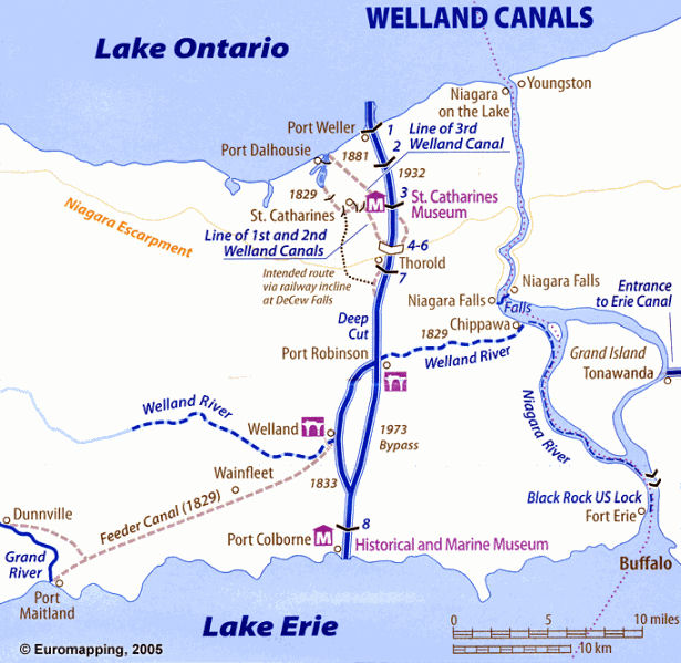
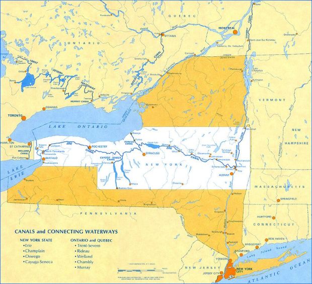


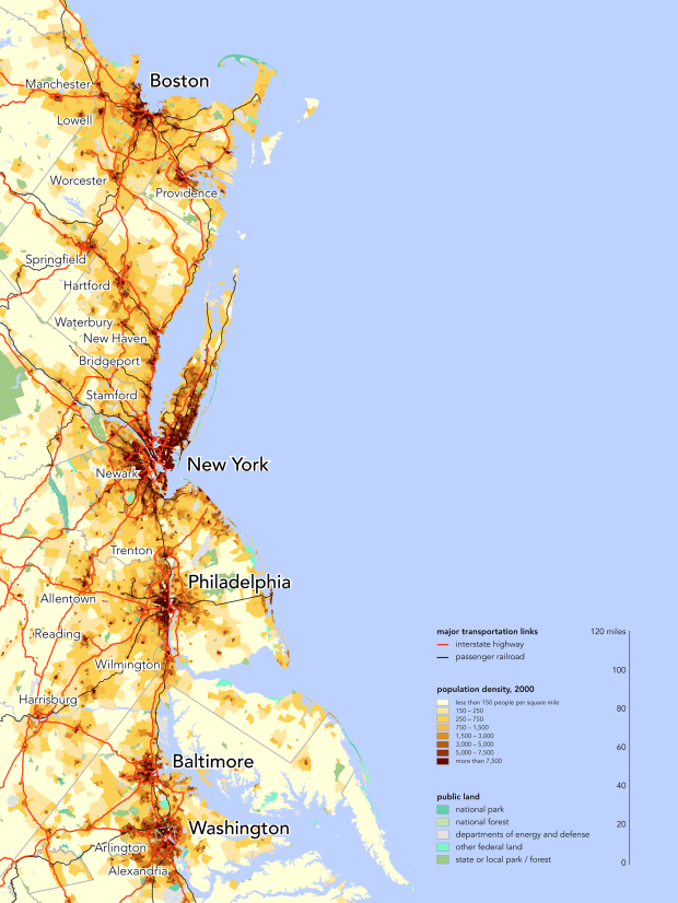
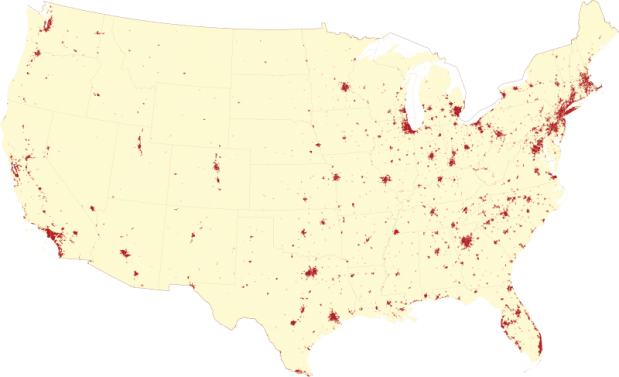
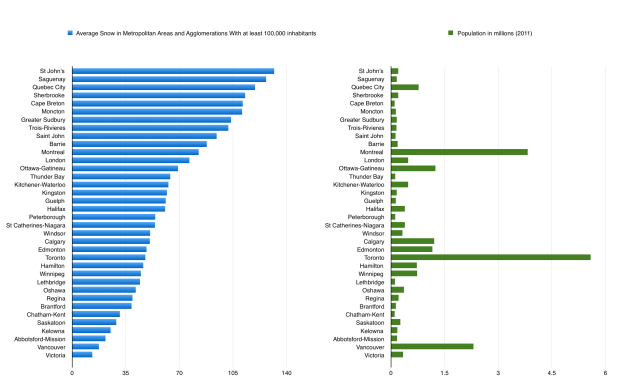
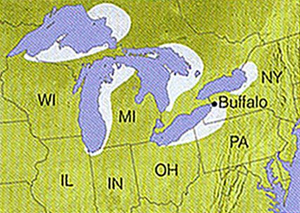


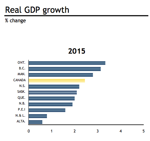
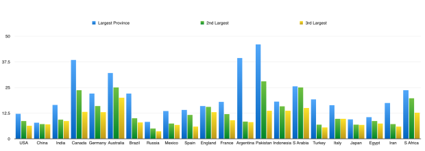
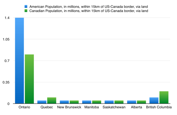
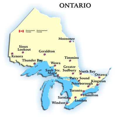
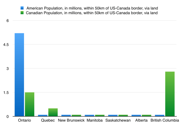

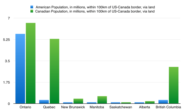
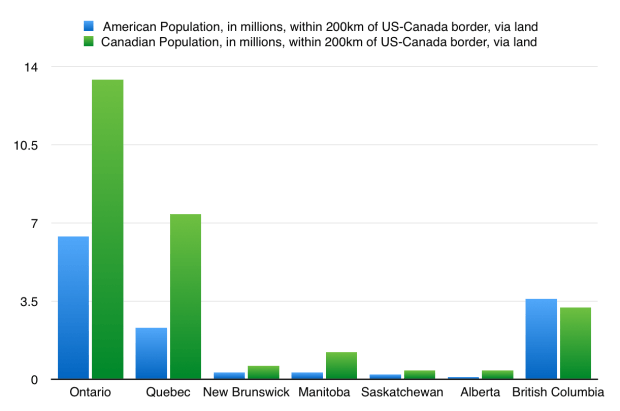
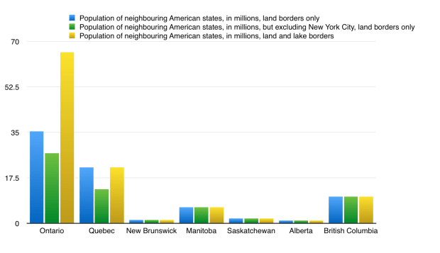
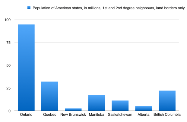
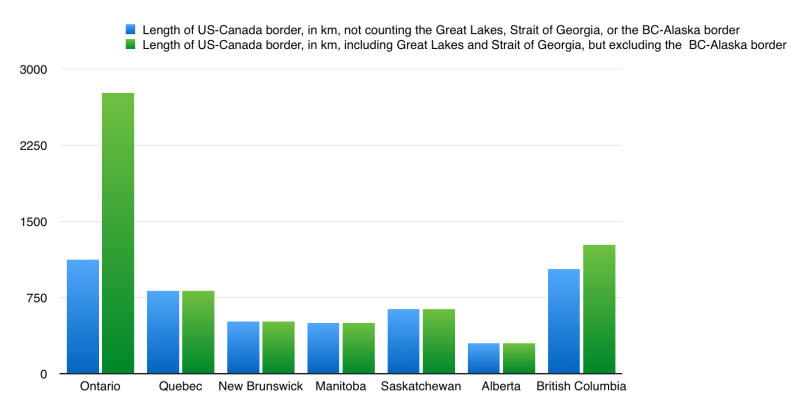
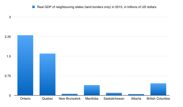
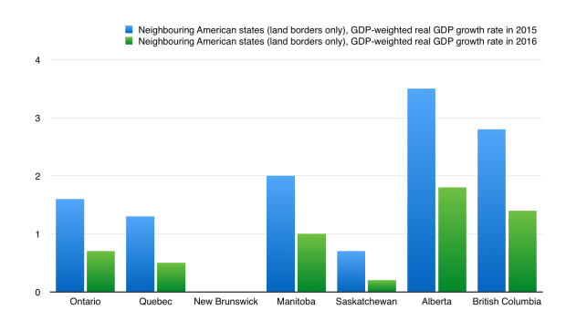

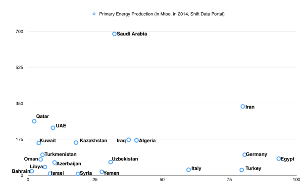


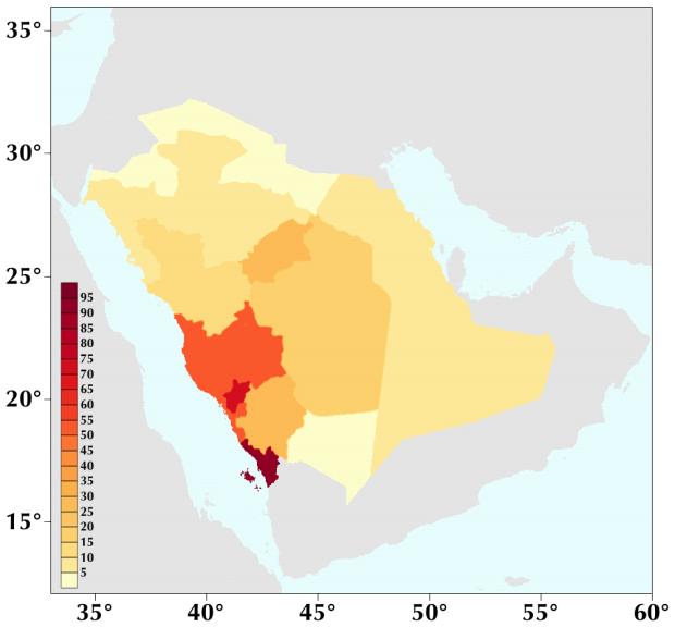
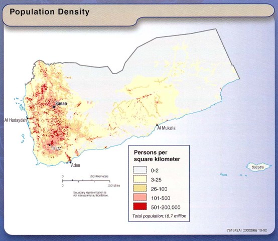

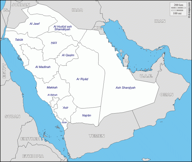
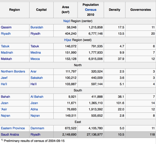
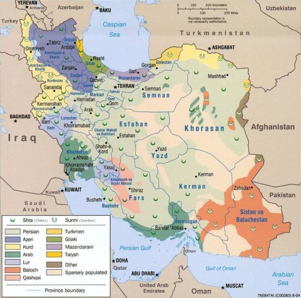
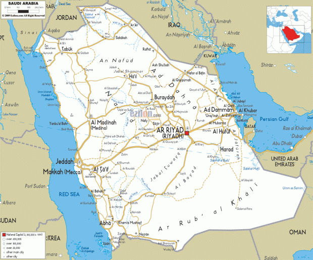

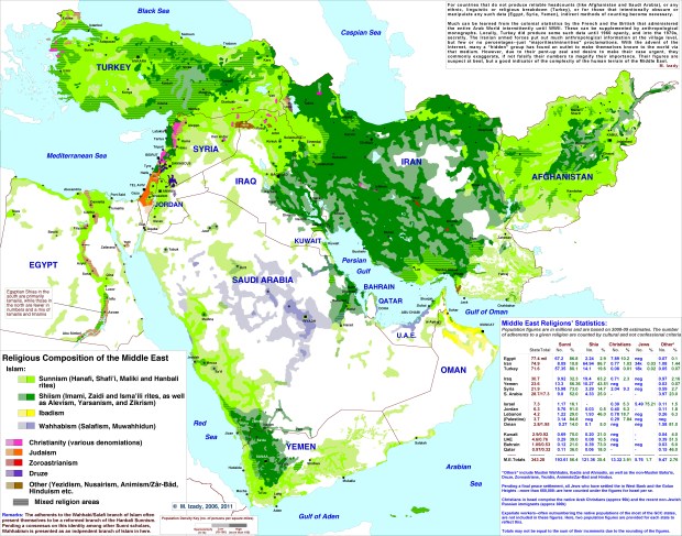
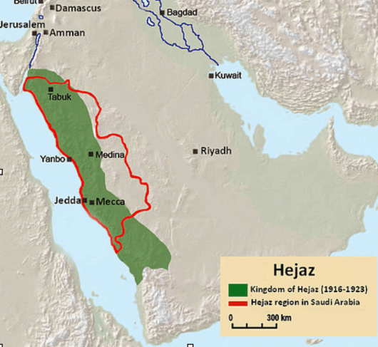
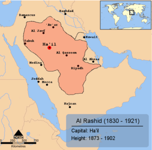
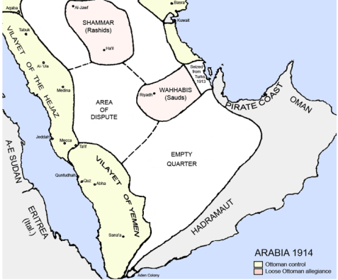
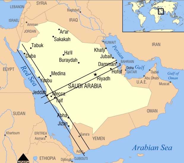
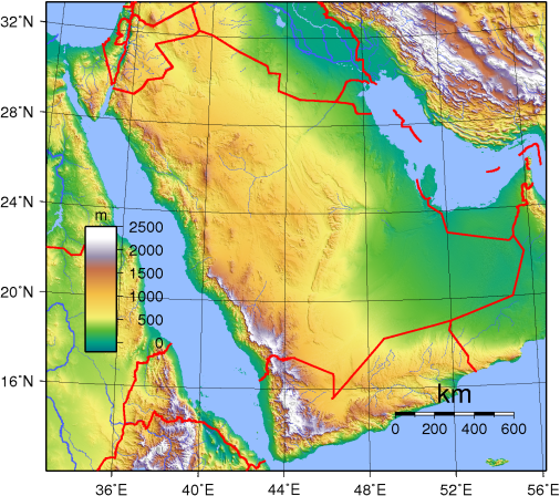
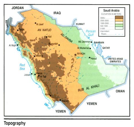
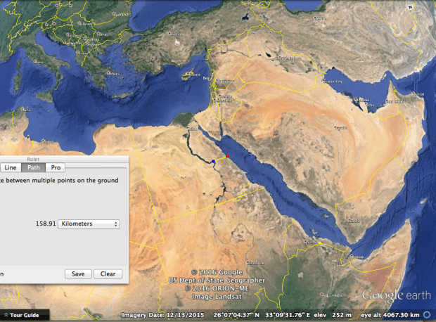
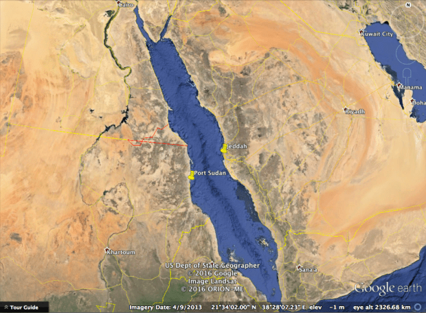


 (Source: The World Bank; Wall Street Journal)